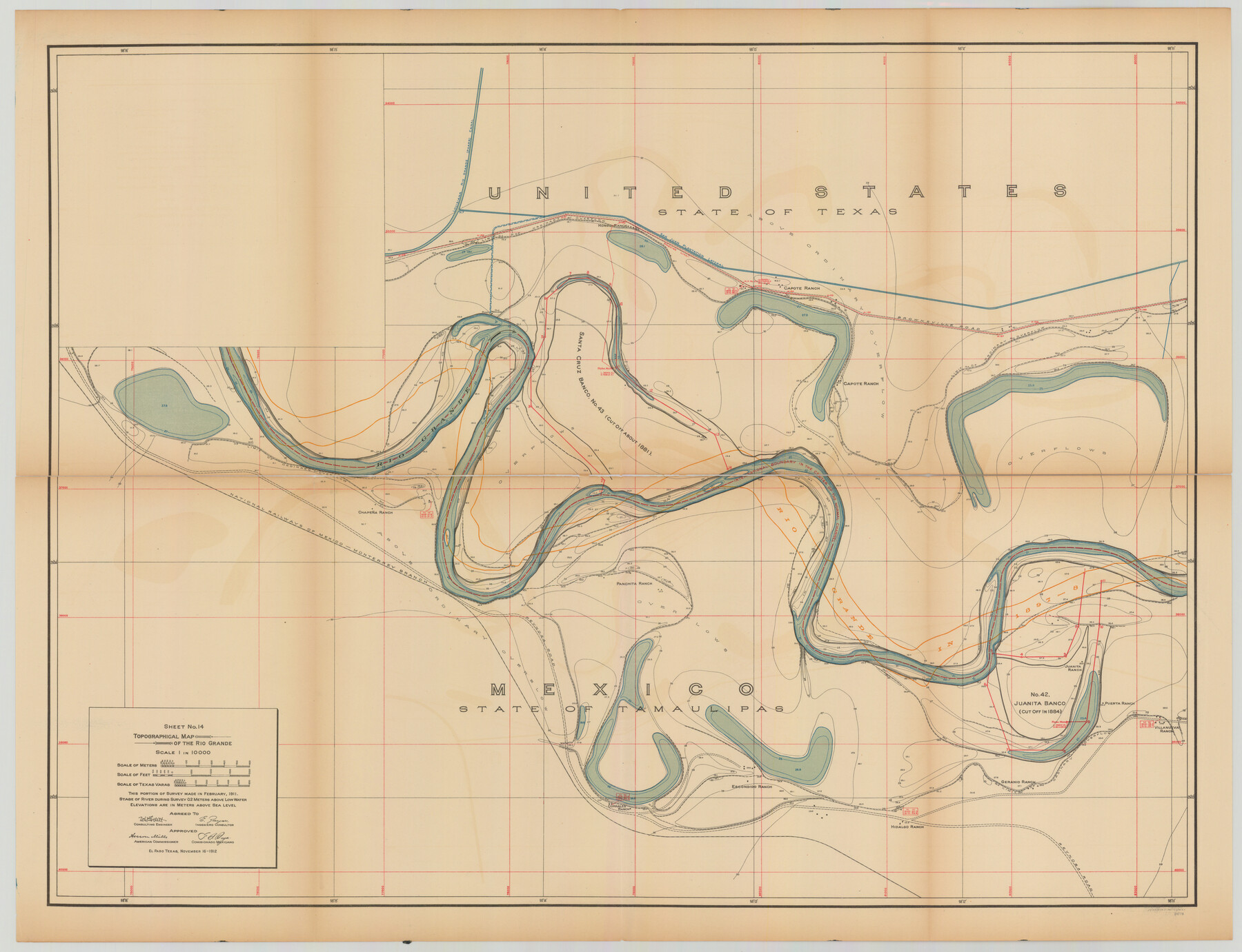
Topographical Map of the Rio Grande, Sheet No. 14
[from book: "Survey of the Rio Grande, Roma to the Gulf of Mexico, Reports and Maps"]
-
Map/Doc
89538
-
Collection
General Map Collection
-
Object Dates
1912/11/16 (Creation Date)
-
People and Organizations
International Boundary Commission (Publisher)
Anson Mills (Author)
E. Zayas (Surveyor/Engineer)
F.B. Puga (Author)
W.W. Follett (Surveyor/Engineer)
-
Subjects
River Surveys Texas Boundaries Topographic
-
Medium
paper
-
Scale
1:10000
-
Comments
This portion of the survey made in February, 1911. State of river during survey 0.2 meters above low water. Elevations are in meters above sea level. This map and 31 others were originally folded and bound into a book titled "Survey of the Rio Grande
Part of: General Map Collection
La Salle County Boundary File 57b

Print $20.00
- Digital $50.00
La Salle County Boundary File 57b
Size 25.6 x 20.6 inches
Map/Doc 56258
Flight Mission No. DAG-18K, Frame 184, Matagorda County

Print $20.00
- Digital $50.00
Flight Mission No. DAG-18K, Frame 184, Matagorda County
1952
Size 18.6 x 22.4 inches
Map/Doc 86376
Chart of the West Indies and Spanish Dominions in North America

Print $40.00
- Digital $50.00
Chart of the West Indies and Spanish Dominions in North America
Size 49.1 x 75.6 inches
Map/Doc 97153
Montgomery County Rolled Sketch 28

Print $20.00
- Digital $50.00
Montgomery County Rolled Sketch 28
1942
Size 35.1 x 22.6 inches
Map/Doc 6810
Matagorda County Aerial Photograph Index Sheet 4

Print $20.00
- Digital $50.00
Matagorda County Aerial Photograph Index Sheet 4
1953
Size 23.6 x 19.5 inches
Map/Doc 83725
Map of Corpus Christi Bay in Nueces County Showing Subdivision Thereof for Mineral Development

Print $20.00
- Digital $50.00
Map of Corpus Christi Bay in Nueces County Showing Subdivision Thereof for Mineral Development
1940
Size 23.3 x 34.7 inches
Map/Doc 2941
Nolan County Sketch File 11

Print $20.00
- Digital $50.00
Nolan County Sketch File 11
1902
Size 18.5 x 37.5 inches
Map/Doc 42162
Rockport Quadrangle

Print $20.00
- Digital $50.00
Rockport Quadrangle
1954
Size 21.3 x 18.3 inches
Map/Doc 73435
Flight Mission No. CGI-3N, Frame 111, Cameron County

Print $20.00
- Digital $50.00
Flight Mission No. CGI-3N, Frame 111, Cameron County
1954
Size 18.6 x 22.2 inches
Map/Doc 84591
Brewster County Sketch File N-15

Print $40.00
- Digital $50.00
Brewster County Sketch File N-15
Size 16.7 x 12.8 inches
Map/Doc 15641
Right of Way and Track Map, International & Gt. Northern Ry. Operated by the International & Gt. Northern Ry. Co., Gulf Division

Print $40.00
- Digital $50.00
Right of Way and Track Map, International & Gt. Northern Ry. Operated by the International & Gt. Northern Ry. Co., Gulf Division
1917
Size 24.9 x 56.6 inches
Map/Doc 64250
Crockett County Rolled Sketch 86

Print $20.00
- Digital $50.00
Crockett County Rolled Sketch 86
1947
Size 31.2 x 27.1 inches
Map/Doc 5626
You may also like
Jackson County

Print $20.00
- Digital $50.00
Jackson County
1840
Size 33.5 x 26.7 inches
Map/Doc 4505
Comanche County Boundary File 2c

Print $8.00
- Digital $50.00
Comanche County Boundary File 2c
Size 14.3 x 8.9 inches
Map/Doc 51796
Topographical Map of the Rio Grande, Sheet No. 17

Print $20.00
- Digital $50.00
Topographical Map of the Rio Grande, Sheet No. 17
1912
Map/Doc 89541
Flight Mission No. DAG-26K, Frame 58, Matagorda County

Print $20.00
- Digital $50.00
Flight Mission No. DAG-26K, Frame 58, Matagorda County
1953
Size 18.5 x 16.1 inches
Map/Doc 86578
Reeves County Sketch File 21

Print $20.00
- Digital $50.00
Reeves County Sketch File 21
Size 21.9 x 21.7 inches
Map/Doc 12246
Erath County Working Sketch 18

Print $20.00
- Digital $50.00
Erath County Working Sketch 18
1962
Size 30.5 x 34.8 inches
Map/Doc 69099
North Sulphur River, Sims Crossing Sheet

Print $20.00
- Digital $50.00
North Sulphur River, Sims Crossing Sheet
1924
Size 23.4 x 39.9 inches
Map/Doc 65167
Knox County Sketch File 20

Print $20.00
- Digital $50.00
Knox County Sketch File 20
1917
Size 26.2 x 17.6 inches
Map/Doc 11962
Kerr County Working Sketch 2

Print $20.00
- Digital $50.00
Kerr County Working Sketch 2
1926
Size 18.6 x 17.9 inches
Map/Doc 70033
Dickens County Sketch File H3

Print $10.00
- Digital $50.00
Dickens County Sketch File H3
1904
Size 10.9 x 8.5 inches
Map/Doc 20876
Flight Mission No. DCL-7C, Frame 39, Kenedy County

Print $20.00
- Digital $50.00
Flight Mission No. DCL-7C, Frame 39, Kenedy County
1943
Size 15.3 x 15.3 inches
Map/Doc 86027
Burleson County Sketch File 9

Print $12.00
- Digital $50.00
Burleson County Sketch File 9
1929
Size 14.2 x 8.1 inches
Map/Doc 16657