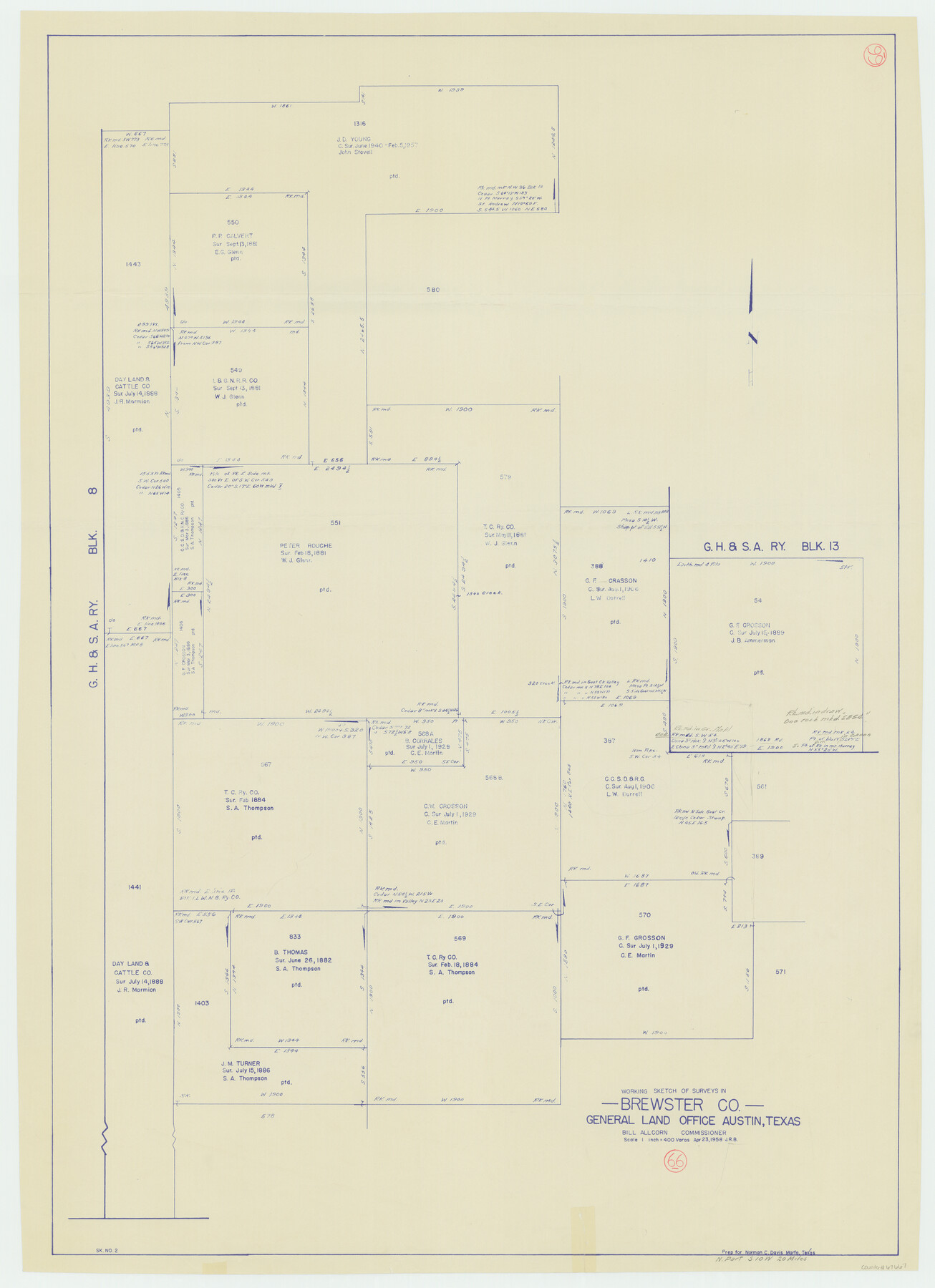
Brewster County Working Sketch 66
-
Map/Doc
67667
-
Collection
General Map Collection
-
Object Dates
4/23/1958 (Creation Date)
-
Counties
Brewster
-
Subjects
Surveying Working Sketch
-
Height x Width
42.2 x 30.6 inches
107.2 x 77.7 cm
-
Scale
1" = 400 varas
Part of: General Map Collection
Jasper County Working Sketch 27

Print $20.00
- Digital $50.00
Jasper County Working Sketch 27
1954
Size 38.3 x 19.4 inches
Map/Doc 66489
Flight Mission No. DCL-4C, Frame 97, Kenedy County

Print $20.00
- Digital $50.00
Flight Mission No. DCL-4C, Frame 97, Kenedy County
1943
Size 18.6 x 22.4 inches
Map/Doc 85818
Freestone County Rolled Sketch 3

Print $67.00
- Digital $50.00
Freestone County Rolled Sketch 3
Size 10.4 x 15.5 inches
Map/Doc 44784
Hudspeth County Sketch File 34

Print $12.00
- Digital $50.00
Hudspeth County Sketch File 34
1944
Size 11.2 x 8.8 inches
Map/Doc 26997
Flight Mission No. DQO-1K, Frame 119, Galveston County

Print $20.00
- Digital $50.00
Flight Mission No. DQO-1K, Frame 119, Galveston County
1952
Size 19.0 x 22.6 inches
Map/Doc 84997
Val Verde County Working Sketch 117

Print $20.00
- Digital $50.00
Val Verde County Working Sketch 117
1993
Size 24.7 x 29.8 inches
Map/Doc 82846
Grimes County Sketch File 3

Print $20.00
- Digital $50.00
Grimes County Sketch File 3
1871
Size 10.6 x 12.1 inches
Map/Doc 24626
Denton County Sketch File 19

Print $10.00
- Digital $50.00
Denton County Sketch File 19
Size 10.0 x 7.3 inches
Map/Doc 20733
Cochran County Boundary File 1

Print $108.00
- Digital $50.00
Cochran County Boundary File 1
Size 15.4 x 8.7 inches
Map/Doc 51445
Deaf Smith Co.

Print $20.00
- Digital $50.00
Deaf Smith Co.
1910
Size 20.2 x 28.1 inches
Map/Doc 1767
Smith County Working Sketch 7

Print $20.00
- Digital $50.00
Smith County Working Sketch 7
1941
Size 27.2 x 20.8 inches
Map/Doc 63892
Map of Hamilton County

Print $20.00
- Digital $50.00
Map of Hamilton County
1872
Size 14.6 x 21.7 inches
Map/Doc 3620
You may also like
Carson County Rolled Sketch 1

Print $20.00
- Digital $50.00
Carson County Rolled Sketch 1
Size 31.2 x 33.4 inches
Map/Doc 8580
Dickens County Sketch File N

Print $4.00
- Digital $50.00
Dickens County Sketch File N
1903
Size 8.3 x 13.6 inches
Map/Doc 20942
Culberson County Working Sketch 1

Print $20.00
- Digital $50.00
Culberson County Working Sketch 1
Size 21.6 x 42.7 inches
Map/Doc 68453
Moore County Rolled Sketch 16

Print $20.00
- Digital $50.00
Moore County Rolled Sketch 16
1981
Size 21.8 x 27.8 inches
Map/Doc 6833
[I. M. Bolton, L. S. Thacker, and R. C. Poteet Subdivisions]
![92578, [I. M. Bolton, L. S. Thacker, and R. C. Poteet Subdivisions], Twichell Survey Records](https://historictexasmaps.com/wmedia_w700/maps/92578-1.tif.jpg)
Print $20.00
- Digital $50.00
[I. M. Bolton, L. S. Thacker, and R. C. Poteet Subdivisions]
1924
Size 18.7 x 24.7 inches
Map/Doc 92578

Cameron County Sketch File 16

Print $18.00
- Digital $50.00
Cameron County Sketch File 16
1998
Size 11.2 x 8.6 inches
Map/Doc 76334
[Block C-41, Sections 32, 35, 35 1/2, and vicinity]
![92570, [Block C-41, Sections 32, 35, 35 1/2, and vicinity], Twichell Survey Records](https://historictexasmaps.com/wmedia_w700/maps/92570-1.tif.jpg)
Print $20.00
- Digital $50.00
[Block C-41, Sections 32, 35, 35 1/2, and vicinity]
Size 23.9 x 19.4 inches
Map/Doc 92570
Kerr County Rolled Sketch 23

Print $20.00
- Digital $50.00
Kerr County Rolled Sketch 23
1966
Size 39.3 x 27.5 inches
Map/Doc 6503
Dickens County Sketch File 8

Print $4.00
- Digital $50.00
Dickens County Sketch File 8
Size 8.8 x 14.2 inches
Map/Doc 20971
[Sketch showing J.S. Brooks, W.B. Aldredge, Madison County School Land and Others]
![89730, [Sketch showing J.S. Brooks, W.B. Aldredge, Madison County School Land and Others], Twichell Survey Records](https://historictexasmaps.com/wmedia_w700/maps/89730-1.tif.jpg)
Print $20.00
- Digital $50.00
[Sketch showing J.S. Brooks, W.B. Aldredge, Madison County School Land and Others]
Size 37.1 x 39.9 inches
Map/Doc 89730
Nueces County Sketch File 68

Print $8.00
- Digital $50.00
Nueces County Sketch File 68
Size 11.0 x 8.7 inches
Map/Doc 33000