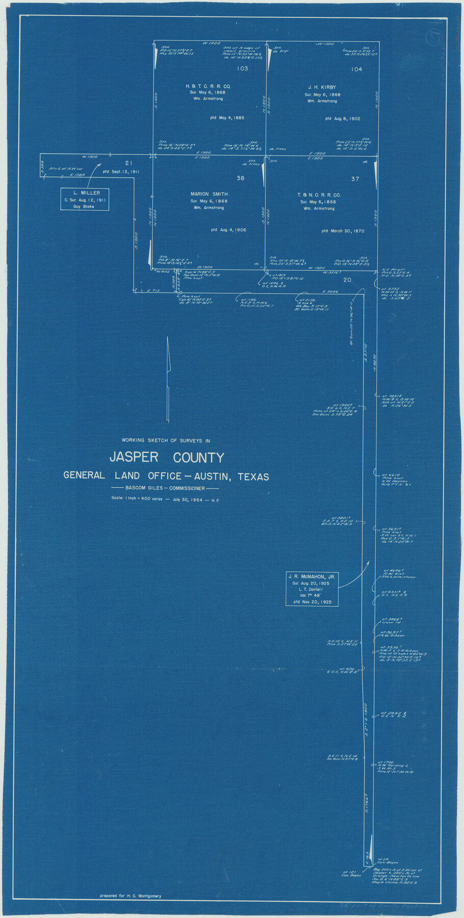
Jasper County Working Sketch 27
-
Map/Doc
66489
-
Collection
General Map Collection
-
Object Dates
7/30/1954 (Creation Date)
-
People and Organizations
Herman Forbes (Draftsman)
-
Counties
Jasper
-
Subjects
Surveying Working Sketch
-
Height x Width
38.3 x 19.4 inches
97.3 x 49.3 cm
-
Scale
1" = 400 varas
Part of: General Map Collection
Flight Mission No. DAH-17M, Frame 19, Orange County

Print $20.00
- Digital $50.00
Flight Mission No. DAH-17M, Frame 19, Orange County
1953
Size 18.6 x 22.6 inches
Map/Doc 86882
Webb County Working Sketch 96

Print $20.00
- Digital $50.00
Webb County Working Sketch 96
1994
Size 36.1 x 36.3 inches
Map/Doc 72463
Childress County Rolled Sketch 8B

Print $20.00
- Digital $50.00
Childress County Rolled Sketch 8B
Size 13.3 x 18.8 inches
Map/Doc 5444
Flight Mission No. CUG-3P, Frame 77, Kleberg County

Print $20.00
- Digital $50.00
Flight Mission No. CUG-3P, Frame 77, Kleberg County
1956
Size 18.7 x 22.4 inches
Map/Doc 86252
Schleicher County Sketch File 8

Print $32.00
- Digital $50.00
Schleicher County Sketch File 8
1881
Size 12.5 x 8.2 inches
Map/Doc 36479
Map of Ramon Musquiz Survey, Meanders of Lavaca & Navidad Rivers, Menefee & Redfish Lakes

Print $20.00
- Digital $50.00
Map of Ramon Musquiz Survey, Meanders of Lavaca & Navidad Rivers, Menefee & Redfish Lakes
1934
Size 23.4 x 18.4 inches
Map/Doc 65455
Cooke County Sketch File 45

Print $20.00
- Digital $50.00
Cooke County Sketch File 45
1849
Size 22.3 x 15.2 inches
Map/Doc 11179
Nueces County Rolled Sketch 45

Print $20.00
- Digital $50.00
Nueces County Rolled Sketch 45
1941
Size 40.5 x 45.0 inches
Map/Doc 10295
Gulf Intracoastal Waterway - Texas Erosion at the West End of Bolivar Peninsula Comparative Shorelines

Print $20.00
- Digital $50.00
Gulf Intracoastal Waterway - Texas Erosion at the West End of Bolivar Peninsula Comparative Shorelines
1950
Size 29.0 x 40.3 inches
Map/Doc 61826
Upshur County Working Sketch 1

Print $20.00
- Digital $50.00
Upshur County Working Sketch 1
1934
Size 28.9 x 32.6 inches
Map/Doc 69557
Val Verde County Working Sketch 73

Print $20.00
- Digital $50.00
Val Verde County Working Sketch 73
1970
Size 37.6 x 34.5 inches
Map/Doc 72208
Collingsworth County Sketch File 1

Print $20.00
- Digital $50.00
Collingsworth County Sketch File 1
1888
Size 23.8 x 28.9 inches
Map/Doc 11128
You may also like
Rail Road Map of Pennsylvania

Print $40.00
- Digital $50.00
Rail Road Map of Pennsylvania
1893
Size 38.4 x 58.1 inches
Map/Doc 97108
Van Zandt County

Print $20.00
- Digital $50.00
Van Zandt County
1870
Size 22.8 x 21.1 inches
Map/Doc 4638
The Woodlands, a real hometown for people and companies

The Woodlands, a real hometown for people and companies
Size 39.7 x 26.4 inches
Map/Doc 94288
Concho County Sketch File 7

Print $6.00
- Digital $50.00
Concho County Sketch File 7
1857
Size 16.4 x 11.5 inches
Map/Doc 19129
Travis County Appraisal District Plat Map 2_0801

Print $20.00
- Digital $50.00
Travis County Appraisal District Plat Map 2_0801
Size 21.4 x 26.4 inches
Map/Doc 94237
Victoria County Working Sketch 8

Print $20.00
- Digital $50.00
Victoria County Working Sketch 8
1957
Size 25.9 x 37.8 inches
Map/Doc 72278
Leon County Rolled Sketch 13

Print $20.00
- Digital $50.00
Leon County Rolled Sketch 13
1975
Size 22.8 x 22.5 inches
Map/Doc 6600
Newton County Rolled Sketch 3

Print $40.00
- Digital $50.00
Newton County Rolled Sketch 3
Size 69.5 x 32.0 inches
Map/Doc 9574
Kerr County Sketch File 21

Print $10.00
- Digital $50.00
Kerr County Sketch File 21
1954
Size 11.1 x 8.7 inches
Map/Doc 28892
Trinity County Working Sketch 15

Print $20.00
- Digital $50.00
Trinity County Working Sketch 15
1974
Size 30.5 x 32.5 inches
Map/Doc 69464
Fisher County Sketch File 13

Print $20.00
- Digital $50.00
Fisher County Sketch File 13
Size 18.3 x 17.7 inches
Map/Doc 11480
40 Acre Lease Units Anton Townsite Hockley County, Texas

Print $20.00
- Digital $50.00
40 Acre Lease Units Anton Townsite Hockley County, Texas
Size 17.1 x 18.5 inches
Map/Doc 92248