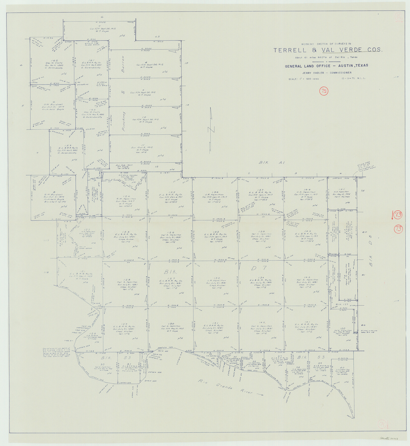
Val Verde County Working Sketch 73
-
Map/Doc
72208
-
Collection
General Map Collection
-
Object Dates
12/9/1970 (Creation Date)
-
People and Organizations
M. L. Liles (Draftsman)
-
Counties
Val Verde Terrell
-
Subjects
Surveying Working Sketch
-
Height x Width
37.6 x 34.5 inches
95.5 x 87.6 cm
-
Scale
1" = 500 varas
Part of: General Map Collection
Sterling County Sketch File 17a

Print $20.00
- Digital $50.00
Sterling County Sketch File 17a
Size 42.8 x 31.6 inches
Map/Doc 10609
Trace of a copy of the map captured at the battle of Resaca de la Palma

Print $20.00
- Digital $50.00
Trace of a copy of the map captured at the battle of Resaca de la Palma
Size 18.3 x 27.3 inches
Map/Doc 73056
Gregg County Rolled Sketch 17

Print $20.00
- Digital $50.00
Gregg County Rolled Sketch 17
1933
Size 14.0 x 27.9 inches
Map/Doc 6040
Val Verde County Working Sketch 117

Print $20.00
- Digital $50.00
Val Verde County Working Sketch 117
1993
Size 17.5 x 24.4 inches
Map/Doc 82848
Flight Mission No. DQN-2K, Frame 119, Calhoun County

Print $20.00
- Digital $50.00
Flight Mission No. DQN-2K, Frame 119, Calhoun County
1953
Size 16.8 x 16.5 inches
Map/Doc 84295
Wheeler County Working Sketch 12

Print $40.00
- Digital $50.00
Wheeler County Working Sketch 12
1978
Size 38.5 x 51.1 inches
Map/Doc 72501
East Part of Edwards County

Print $40.00
- Digital $50.00
East Part of Edwards County
1975
Size 56.3 x 41.1 inches
Map/Doc 95488
Galveston Bay and Approaches

Print $20.00
- Digital $50.00
Galveston Bay and Approaches
1957
Size 43.6 x 32.7 inches
Map/Doc 69877
City of Austin, Texas and Suburban Areas

Print $40.00
- Digital $50.00
City of Austin, Texas and Suburban Areas
1964
Size 48.3 x 34.4 inches
Map/Doc 73563
Map of Anderson County

Print $20.00
- Digital $50.00
Map of Anderson County
1876
Size 19.4 x 21.9 inches
Map/Doc 3228
Brazos River, Brazos River Sheet 1

Print $20.00
- Digital $50.00
Brazos River, Brazos River Sheet 1
1926
Size 20.7 x 25.3 inches
Map/Doc 69665
[Jack District]
![16828, [Jack District], General Map Collection](https://historictexasmaps.com/wmedia_w700/maps/16828.tif.jpg)
Print $40.00
- Digital $50.00
[Jack District]
1876
Size 50.0 x 76.4 inches
Map/Doc 16828
You may also like
Duval County Sketch File 16

Print $6.00
- Digital $50.00
Duval County Sketch File 16
1875
Size 7.4 x 8.2 inches
Map/Doc 21311
Rio Grande, Raymondville Sheet

Print $20.00
- Digital $50.00
Rio Grande, Raymondville Sheet
1937
Size 37.3 x 37.9 inches
Map/Doc 65110
Polk County Sketch File 2

Print $4.00
- Digital $50.00
Polk County Sketch File 2
1856
Size 8.2 x 8.1 inches
Map/Doc 34118
Oldham County Boundary File 1

Print $6.00
- Digital $50.00
Oldham County Boundary File 1
Size 8.8 x 7.2 inches
Map/Doc 57731
Shelby County Working Sketch 8

Print $20.00
- Digital $50.00
Shelby County Working Sketch 8
1942
Size 20.0 x 30.3 inches
Map/Doc 63861
Starr County Sketch File 12

Print $20.00
- Digital $50.00
Starr County Sketch File 12
1886
Size 16.2 x 23.7 inches
Map/Doc 12328
[Plat map showing mostly Overton Addition]
![92812, [Plat map showing mostly Overton Addition], Twichell Survey Records](https://historictexasmaps.com/wmedia_w700/maps/92812-1.tif.jpg)
Print $20.00
- Digital $50.00
[Plat map showing mostly Overton Addition]
Size 31.9 x 31.3 inches
Map/Doc 92812
Mills County Sketch File 6

Print $4.00
- Digital $50.00
Mills County Sketch File 6
Size 9.0 x 9.8 inches
Map/Doc 31655
Cameron County Rolled Sketch 25

Print $20.00
- Digital $50.00
Cameron County Rolled Sketch 25
1977
Size 17.5 x 27.5 inches
Map/Doc 5790
Wichita County Sketch File 21

Print $4.00
- Digital $50.00
Wichita County Sketch File 21
Size 11.5 x 8.8 inches
Map/Doc 40102
Chambers County Sketch File 21

Print $20.00
- Digital $50.00
Chambers County Sketch File 21
Size 29.3 x 32.8 inches
Map/Doc 10331
Section N Tech Memorial Park, Inc.

Print $20.00
- Digital $50.00
Section N Tech Memorial Park, Inc.
1950
Size 16.6 x 18.8 inches
Map/Doc 92307