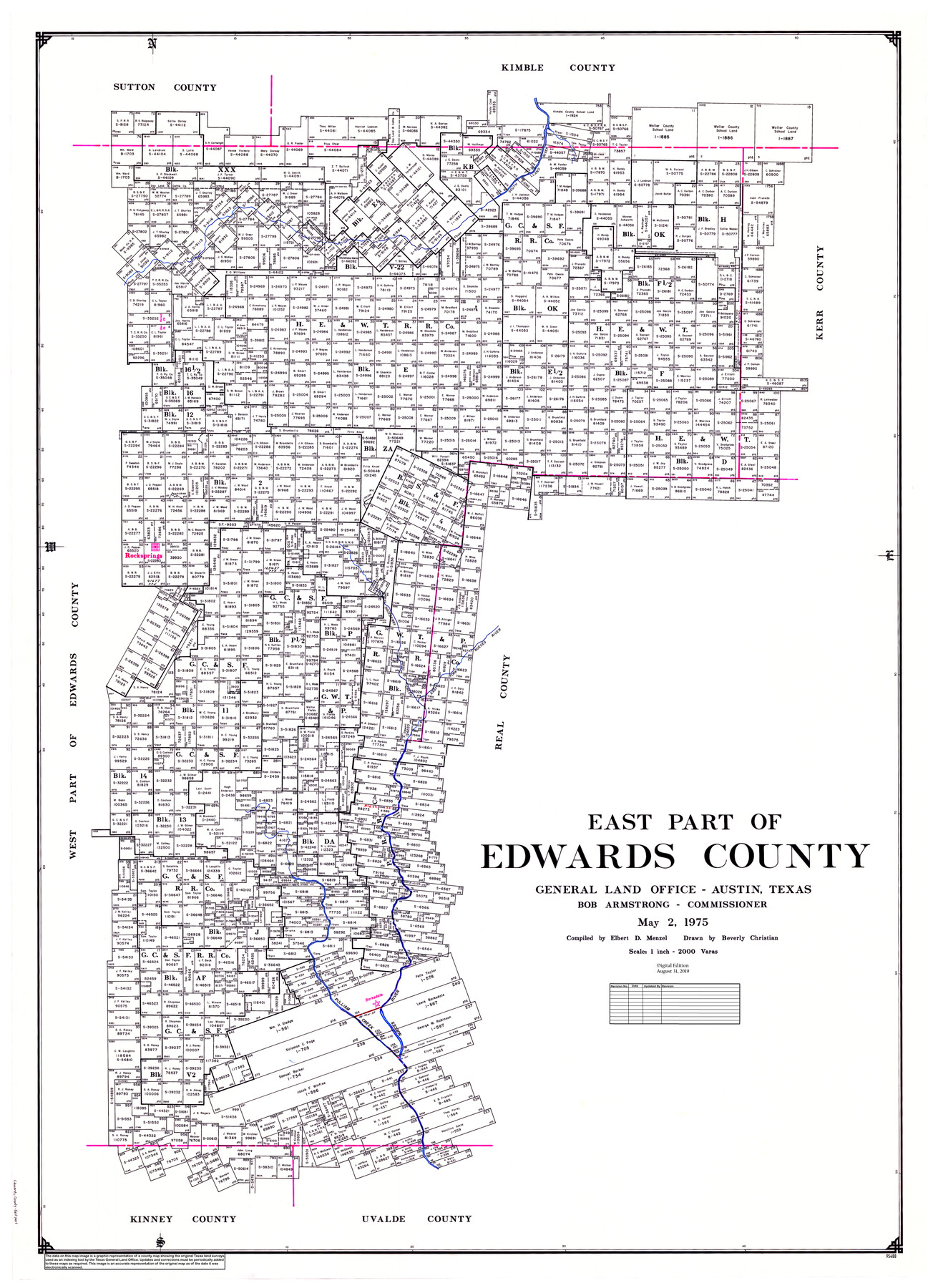
East Part of Edwards County
General Land Office Official County Map
-
Map/Doc
95488
-
Collection
General Map Collection
-
Object Dates
1975/5/2 (Creation Date)
2019/8/31 (Revision Date)
-
People and Organizations
Beverly Christian (Draftsman)
Cheyenne Betancourt (Draftsman)
Bob Armstrong (GLO Commissioner)
Elbert Menzel (Compiler)
-
Counties
Edwards
-
Subjects
County OCM
-
Height x Width
56.3 x 41.1 inches
143.0 x 104.4 cm
-
Medium
digital image
-
Scale
1" = 2000 varas
-
Comments
For west part of Edwards County, see map 95489.
Related maps
West Part of Edwards County

Print $40.00
- Digital $50.00
West Part of Edwards County
1975
Size 59.9 x 39.7 inches
Map/Doc 95489
Part of: General Map Collection
Parker County Working Sketch 27

Print $20.00
- Digital $50.00
Parker County Working Sketch 27
2009
Map/Doc 89001
Blanco County Sketch File 11

Print $4.00
- Digital $50.00
Blanco County Sketch File 11
Size 4.0 x 7.6 inches
Map/Doc 14590
San Patricio County Rolled Sketch 37

Print $127.00
- Digital $50.00
San Patricio County Rolled Sketch 37
Size 10.3 x 15.2 inches
Map/Doc 48888
Kinney County Sketch File 28

Print $8.00
- Digital $50.00
Kinney County Sketch File 28
1929
Size 11.3 x 9.0 inches
Map/Doc 29167
Jack County Working Sketch 19

Print $20.00
- Digital $50.00
Jack County Working Sketch 19
1989
Size 21.5 x 29.4 inches
Map/Doc 66445
Crockett County Rolled Sketch 59

Print $20.00
- Digital $50.00
Crockett County Rolled Sketch 59
1946
Size 30.1 x 20.9 inches
Map/Doc 5602
Val Verde County Rolled Sketch 68

Print $20.00
- Digital $50.00
Val Verde County Rolled Sketch 68
1958
Size 17.6 x 18.7 inches
Map/Doc 8131
Presidio County Working Sketch 70

Print $20.00
- Digital $50.00
Presidio County Working Sketch 70
1961
Size 46.8 x 37.4 inches
Map/Doc 71747
Plan of Driving Park Addition composed of Out-lots 37, 38, 39, 49, 50, 60, & 61, Division "O" in the City of Austin

Print $20.00
- Digital $50.00
Plan of Driving Park Addition composed of Out-lots 37, 38, 39, 49, 50, 60, & 61, Division "O" in the City of Austin
1910
Size 18.4 x 15.9 inches
Map/Doc 2024
Right of Way and Track Map, International & Gt. Northern Ry. Operated by the International & Gt. Northern Ry. Co., Gulf Division

Print $40.00
- Digital $50.00
Right of Way and Track Map, International & Gt. Northern Ry. Operated by the International & Gt. Northern Ry. Co., Gulf Division
1917
Size 25.1 x 56.6 inches
Map/Doc 64252
Kimble County Rolled Sketch 28

Print $20.00
- Digital $50.00
Kimble County Rolled Sketch 28
1964
Size 19.7 x 20.6 inches
Map/Doc 6518
[Surveys along the Red River made for titles under Radford Berry, Commissioner]
![32, [Surveys along the Red River made for titles under Radford Berry, Commissioner], General Map Collection](https://historictexasmaps.com/wmedia_w700/maps/32.tif.jpg)
Print $20.00
- Digital $50.00
[Surveys along the Red River made for titles under Radford Berry, Commissioner]
Size 23.3 x 19.5 inches
Map/Doc 32
You may also like
Mitchell County Working Sketch 1

Print $20.00
- Digital $50.00
Mitchell County Working Sketch 1
1905
Size 24.2 x 20.7 inches
Map/Doc 71058
Map of Victoria County

Print $20.00
- Digital $50.00
Map of Victoria County
1873
Size 20.9 x 19.3 inches
Map/Doc 4639

Texas Coast Showing Points of Occupation of Expedition Under Maj. Gen. N.P. Banks, Novr. 1863

Print $20.00
Texas Coast Showing Points of Occupation of Expedition Under Maj. Gen. N.P. Banks, Novr. 1863
1863
Size 16.0 x 17.1 inches
Map/Doc 88593
Report of Construction re: MA 46948, H. C. Henson

Print $2.00
- Digital $50.00
Report of Construction re: MA 46948, H. C. Henson
1954
Size 11.1 x 8.9 inches
Map/Doc 62571
Cherokee County Sketch File 30

Print $17.00
- Digital $50.00
Cherokee County Sketch File 30
1934
Size 10.3 x 9.4 inches
Map/Doc 18176
Flight Mission No. CRC-2R, Frame 4, Chambers County

Print $20.00
- Digital $50.00
Flight Mission No. CRC-2R, Frame 4, Chambers County
1956
Size 18.7 x 22.4 inches
Map/Doc 84723
Crockett County Rolled Sketch 93

Print $20.00
- Digital $50.00
Crockett County Rolled Sketch 93
1979
Size 18.8 x 18.9 inches
Map/Doc 5633
Flight Mission No. CLL-1N, Frame 197, Willacy County

Print $20.00
- Digital $50.00
Flight Mission No. CLL-1N, Frame 197, Willacy County
1954
Size 18.4 x 22.1 inches
Map/Doc 87067
[Sketch of Blocks M-19, 21W, JAD, 9 and G. & M. Block 5]
![91736, [Sketch of Blocks M-19, 21W, JAD, 9 and G. & M. Block 5], Twichell Survey Records](https://historictexasmaps.com/wmedia_w700/maps/91736-1.tif.jpg)
Print $20.00
- Digital $50.00
[Sketch of Blocks M-19, 21W, JAD, 9 and G. & M. Block 5]
Size 34.0 x 25.9 inches
Map/Doc 91736
Hunt Co., 1894

Print $40.00
- Digital $50.00
Hunt Co., 1894
1894
Size 30.3 x 49.2 inches
Map/Doc 89652
Hardin County Working Sketch 43

Print $20.00
- Digital $50.00
Hardin County Working Sketch 43
2001
Size 45.4 x 37.4 inches
Map/Doc 83572