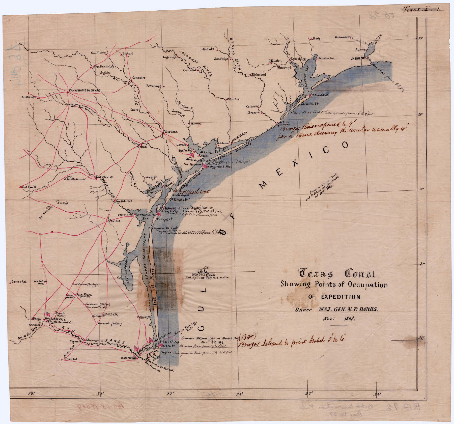
Texas Coast Showing Points of Occupation of Expedition Under Maj. Gen. N.P. Banks, Novr. 1863
-
Map/Doc
88593
-
Collection
National Archives Digital Map Collection
-
Object Dates
1863 (Creation Date)
-
People and Organizations
War Department, Office of Quartermaster General (Publisher)
N.P. Banks (Military Officer)
-
Subjects
Gulf of Mexico Military
-
Height x Width
16.0 x 17.1 inches
40.6 x 43.4 cm
-
Medium
digital image
-
Comments
Coastal waters outlined in blue and roads in red. U. S. flags, in color, indicate points of occupation. Notes relate to the events of the expedition and to the navigability of passes and channels.
Item is located at the National Archives, NA Identifier: 305823 -
Features
San Marcos
Lockart [sic]
New Braunfels
Seguin
Rio Guadalupe
Gonzales
Petersburg
Colorado River
Lagrange [sic]
Columbus
Bellville
San Felipe
Brazos River
Richmond
Houston
Harrisburg
San Jacinto River
Lynchburg
Liberty
Galveston Bay
Beaumont
Chambersia
Aurora
Sabine River
Sabine City
Sabine Pass
Galveston
Galveston Island
Velasco
Quintana
Columbia
Brazoria
Wharton
Navidad River
Lavaca River
Texana
Cuero
San Antonio de Bexar
Rio San Antonio
Victoria
Castroville
Goliad
Lavaca
Indianola
Matagorda Bay
Port Austin
Matagorda
Matagorda Peninsula
LaSalle
Saluria Lighthouse
Fort Esperance
Pass Cavallo
Pelican Island
Matagorda Lighthouse
Espiritu Santo Bay
Lamar
Refugio
Aransas Bay
Aransas River
St. Joseph's Island
Fort Merrill
Nueces River
San Patricio
South Cajo Badernio
San Cajo
Fort Ewell
Dos Hermanos
Palo Alto
Corpus Christi
Corpus Christi Bay
Mustang Island
Corpus Christi Pass
Salt Lagoon
Laguna de la Madre
Isle del Padre
Las Animas Spring
Carizo Post Office
Santo Teresa Springs
Salt Lake
San Ramon
San Juanito
Lanaria
Almonte
Rio Grande City
Roma
Camargo
Rio de San Juan
Rio Grande
Bridle Path
Torrecillas
Ringold Barracks
Edinburgh
Matamoras [sic]
Sal Colorado Creek
Brownsville
Fort Brown
Lomita
Barrit
Brazos St. Iago
Point Isabelle
Brazos Island
Bagdad
San Antonio de Sabinito
San Francisco
-
URLs
https://medium.com/save-texas-history/texas-coast-showing-points-of-occupation-of-expedition-under-major-general-n-p-92f9f8fdf381
Part of: National Archives Digital Map Collection
Eastern and Central Texas, Prepared by Order of Maj. Gen. N.P. Banks. Major D.C. Houston, Chief of Engineers

Print $20.00
Eastern and Central Texas, Prepared by Order of Maj. Gen. N.P. Banks. Major D.C. Houston, Chief of Engineers
1864
Size 32.6 x 23.7 inches
Map/Doc 88596
Topographical Map of the country between San Antonio & Colorado Rivers in the State of Texas.

Print $40.00
Topographical Map of the country between San Antonio & Colorado Rivers in the State of Texas.
1864
Size 53.4 x 69.8 inches
Map/Doc 88605
Reconnoissance of Sabine River and Valley

Print $20.00
Reconnoissance of Sabine River and Valley
1863
Size 30.4 x 42.5 inches
Map/Doc 97498
Topographical Map of the country between San Antonio & Colorado Rivers in the State of Texas.

Print $40.00
Topographical Map of the country between San Antonio & Colorado Rivers in the State of Texas.
1864
Size 53.2 x 74.8 inches
Map/Doc 88606
Map of Works of Defense near Gonzales, Tex.

Print $20.00
Map of Works of Defense near Gonzales, Tex.
1863
Size 17.1 x 21.8 inches
Map/Doc 88598
Reconnoissance of Sabine River and Vicinty

Print $20.00
Reconnoissance of Sabine River and Vicinty
1863
Size 30.4 x 42.3 inches
Map/Doc 97497
Reconnoissance of Sabine River and Valley

Print $20.00
Reconnoissance of Sabine River and Valley
1863
Size 42.5 x 30.3 inches
Map/Doc 97500
Map of Galveston, Texas, Showing the Rebel Line of Works. Surveyed and Drawn by Order of G.L. Gillespie, Brevet Major and Chief Engr., Mil. Div. of the Gulf, Under the Direction of Lt. S.E. McGregory, Comdg. Topl. Party, by Pl. St. Vignes, Asst.

Print $20.00
Map of Galveston, Texas, Showing the Rebel Line of Works. Surveyed and Drawn by Order of G.L. Gillespie, Brevet Major and Chief Engr., Mil. Div. of the Gulf, Under the Direction of Lt. S.E. McGregory, Comdg. Topl. Party, by Pl. St. Vignes, Asst.
1861
Size 25.3 x 38.7 inches
Map/Doc 88594
Reconnoissance of Sabine River and Valley

Print $20.00
Reconnoissance of Sabine River and Valley
1863
Size 42.3 x 30.0 inches
Map/Doc 97501
[Map of Area near Alamo showing proposed fortifications]
![88603, [Map of Area near Alamo showing proposed fortifications], National Archives Digital Map Collection](https://historictexasmaps.com/wmedia_w700/maps/88603.tif.jpg)
Print $20.00
[Map of Area near Alamo showing proposed fortifications]
1863
Size 31.9 x 27.7 inches
Map/Doc 88603
Map of Pass Cavallo, Texas, Showing the position of the Rebel fortifications and rifle pits.

Print $20.00
Map of Pass Cavallo, Texas, Showing the position of the Rebel fortifications and rifle pits.
1863
Size 23.8 x 21.0 inches
Map/Doc 88595

You may also like
Kinney County Rolled Sketch 14

Print $20.00
- Digital $50.00
Kinney County Rolled Sketch 14
1956
Size 19.5 x 25.8 inches
Map/Doc 6543
Hockley County Sketch File 19b

Print $28.00
- Digital $50.00
Hockley County Sketch File 19b
Size 11.3 x 8.8 inches
Map/Doc 26555
Right of Way and Track Map, the Missouri, Kansas and Texas Ry. of Texas - Henrietta Division

Print $20.00
- Digital $50.00
Right of Way and Track Map, the Missouri, Kansas and Texas Ry. of Texas - Henrietta Division
1918
Size 11.8 x 26.8 inches
Map/Doc 64755
Stephens County Boundary File 5

Print $8.00
- Digital $50.00
Stephens County Boundary File 5
Size 7.6 x 6.4 inches
Map/Doc 58897
Zavala County Boundary File 2a

Print $56.00
- Digital $50.00
Zavala County Boundary File 2a
Size 14.2 x 8.8 inches
Map/Doc 60248
Pecos County Sketch File 118

Print $28.00
- Digital $50.00
Pecos County Sketch File 118
1933
Size 5.0 x 7.5 inches
Map/Doc 34097
Webb County Sketch File 50

Print $20.00
- Digital $50.00
Webb County Sketch File 50
1939
Size 27.4 x 18.6 inches
Map/Doc 12648
Matagorda County Sketch File 15

Print $48.00
- Digital $50.00
Matagorda County Sketch File 15
Size 8.7 x 11.2 inches
Map/Doc 30774
Flight Mission No. CRK-7P, Frame 132, Refugio County

Print $20.00
- Digital $50.00
Flight Mission No. CRK-7P, Frame 132, Refugio County
1956
Size 18.3 x 22.1 inches
Map/Doc 86955
[Part of Bexar District]
![1958, [Part of Bexar District], General Map Collection](https://historictexasmaps.com/wmedia_w700/maps/1958-1.tif.jpg)
Print $20.00
- Digital $50.00
[Part of Bexar District]
1847
Size 40.9 x 27.8 inches
Map/Doc 1958
Matagorda County Rolled Sketch 35

Print $20.00
- Digital $50.00
Matagorda County Rolled Sketch 35
1903
Size 18.6 x 38.0 inches
Map/Doc 6696
Young County Sketch File 16

Print $4.00
- Digital $50.00
Young County Sketch File 16
1896
Size 10.3 x 8.5 inches
Map/Doc 40880