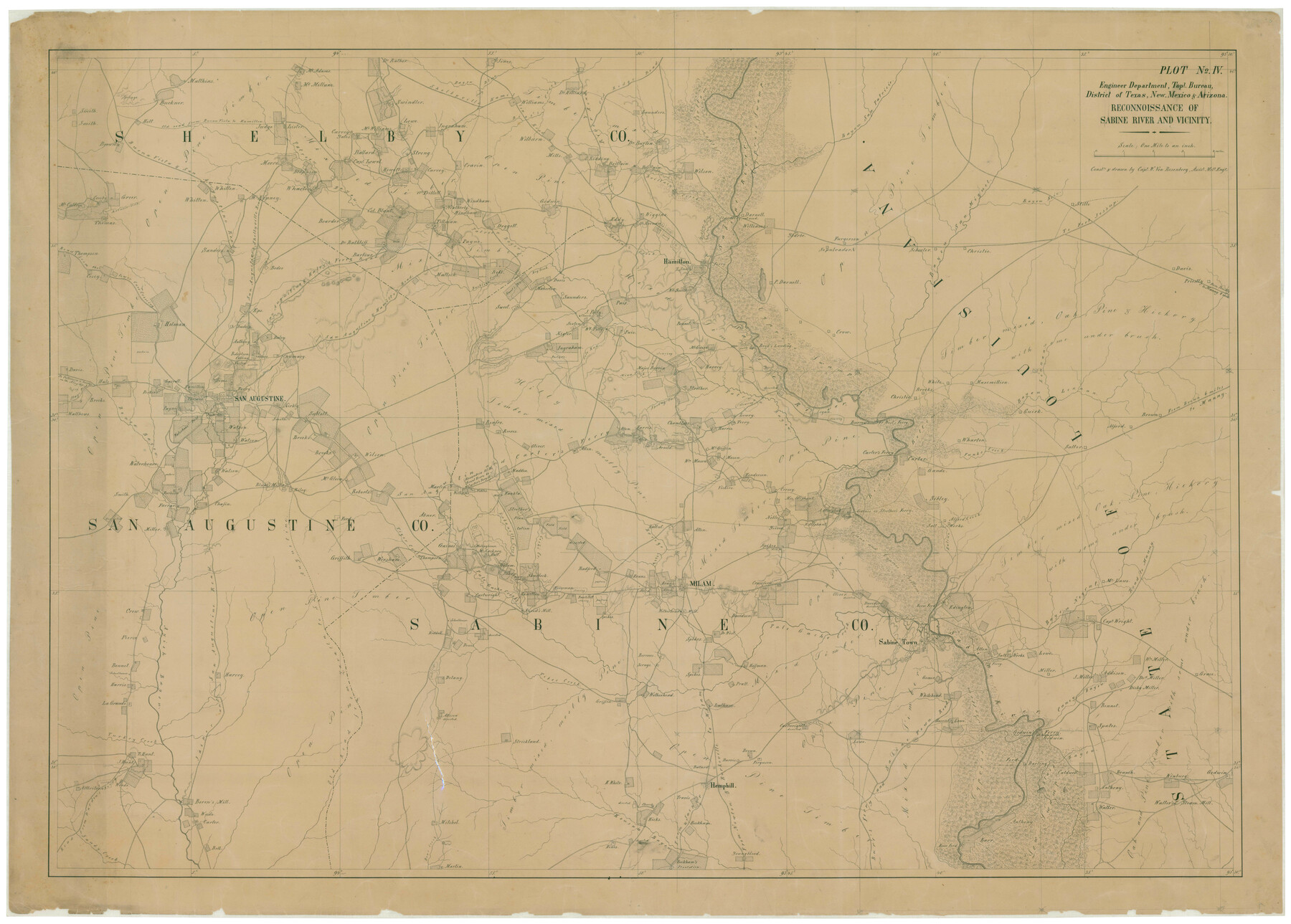
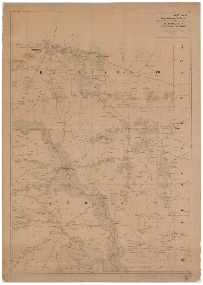
Reconnoissance of Sabine River and Valley
Plot No. IV
-
Map/Doc
97498
-
Collection
National Archives Digital Map Collection
-
Object Dates
[1863] (Creation Date)
-
People and Organizations
William Von Rosenberg (Cartographer)
Topographical Bureau of Texas, New Mexico and Ariz (Publisher)
-
Counties
Shelby San Augustine Sabine
-
Subjects
Topographic Civil War
-
Height x Width
30.4 x 42.5 inches
77.2 x 108.0 cm
-
Medium
digital image
-
Scale
1" = 1 mile
-
Comments
Item is located at the National Archives, NAID: 200061776
Also see maps 97497 and 97499-97501.
Related maps
Reconnoissance of Sabine River and Vicinty

Print $20.00
Reconnoissance of Sabine River and Vicinty
1863
Size 30.4 x 42.3 inches
Map/Doc 97497
Reconnoissance of Sabine River and Valley

Print $20.00
Reconnoissance of Sabine River and Valley
1863
Size 30.2 x 42.3 inches
Map/Doc 97499
Reconnoissance of Sabine River and Valley
Print $20.00
Reconnoissance of Sabine River and Valley
1863
Size 42.5 x 30.3 inches
Map/Doc 97500
Reconnoissance of Sabine River and Valley

Print $20.00
Reconnoissance of Sabine River and Valley
1863
Size 42.3 x 30.0 inches
Map/Doc 97501
Part of: National Archives Digital Map Collection
Reconnoissance of Sabine River and Valley
Print $20.00
Reconnoissance of Sabine River and Valley
1863
Size 42.5 x 30.3 inches
Map/Doc 97500
Topographical Map of the country between San Antonio & Colorado Rivers in the State of Texas.

Print $40.00
Topographical Map of the country between San Antonio & Colorado Rivers in the State of Texas.
1864
Size 53.2 x 74.8 inches
Map/Doc 88606

Topographical Map of the country between San Antonio & Colorado Rivers in the State of Texas.

Print $40.00
Topographical Map of the country between San Antonio & Colorado Rivers in the State of Texas.
1864
Size 53.3 x 69.2 inches
Map/Doc 88604
Reconnoissance of Sabine River and Valley

Print $20.00
Reconnoissance of Sabine River and Valley
1863
Size 30.4 x 42.5 inches
Map/Doc 97498
Map of Works of Defense near Gonzales, Tex.

Print $20.00
Map of Works of Defense near Gonzales, Tex.
1863
Size 17.1 x 21.8 inches
Map/Doc 88598
Map of Pass Cavallo, Texas, Showing the position of the Rebel fortifications and rifle pits.

Print $20.00
Map of Pass Cavallo, Texas, Showing the position of the Rebel fortifications and rifle pits.
1863
Size 23.8 x 21.0 inches
Map/Doc 88595
Reconnoissance of Sabine River and Valley
Print $20.00
Reconnoissance of Sabine River and Valley
1863
Size 30.2 x 42.3 inches
Map/Doc 97499
Texas Coast Showing Points of Occupation of Expedition Under Maj. Gen. N.P. Banks, Novr. 1863

Print $20.00
Texas Coast Showing Points of Occupation of Expedition Under Maj. Gen. N.P. Banks, Novr. 1863
1863
Size 16.0 x 17.1 inches
Map/Doc 88593
Eastern and Central Texas, Prepared by Order of Maj. Gen. N.P. Banks. Major D.C. Houston, Chief of Engineers

Print $20.00
Eastern and Central Texas, Prepared by Order of Maj. Gen. N.P. Banks. Major D.C. Houston, Chief of Engineers
1864
Size 32.6 x 23.7 inches
Map/Doc 88596
Reconnoissance of Sabine River and Valley
Print $20.00
Reconnoissance of Sabine River and Valley
1863
Size 42.3 x 30.0 inches
Map/Doc 97501
Topographical Map of the country between San Antonio & Colorado Rivers in the State of Texas.

Print $40.00
Topographical Map of the country between San Antonio & Colorado Rivers in the State of Texas.
1864
Size 53.4 x 69.8 inches
Map/Doc 88605
You may also like
Pecos County Working Sketch 45

Print $20.00
- Digital $50.00
Pecos County Working Sketch 45
1946
Size 20.8 x 26.7 inches
Map/Doc 71517
Revised Sectional Map Number 2, Showing Land Surveys in Counties of Howard, Martin, Andrews, Glasscock, Midland, Ector, and Portions of Borden, Dawson, Irion, Reagan, Upton, Crane, Ward, and Winkler, Texas

Print $20.00
- Digital $50.00
Revised Sectional Map Number 2, Showing Land Surveys in Counties of Howard, Martin, Andrews, Glasscock, Midland, Ector, and Portions of Borden, Dawson, Irion, Reagan, Upton, Crane, Ward, and Winkler, Texas
Size 20.0 x 25.4 inches
Map/Doc 91358
Comal County Rolled Sketch 5

Print $20.00
- Digital $50.00
Comal County Rolled Sketch 5
1985
Size 30.6 x 26.7 inches
Map/Doc 5540
Flight Mission No. DQO-8K, Frame 144, Galveston County

Print $20.00
- Digital $50.00
Flight Mission No. DQO-8K, Frame 144, Galveston County
1952
Size 18.7 x 22.5 inches
Map/Doc 85206
Edwards County Working Sketch 46

Print $20.00
- Digital $50.00
Edwards County Working Sketch 46
1950
Size 39.8 x 37.4 inches
Map/Doc 68922
Stonewall County Working Sketch 19

Print $20.00
- Digital $50.00
Stonewall County Working Sketch 19
1957
Size 35.3 x 35.1 inches
Map/Doc 62326
Signal Hill Texas

Print $20.00
- Digital $50.00
Signal Hill Texas
Size 17.5 x 17.7 inches
Map/Doc 92112
Crockett County Sketch File 46

Print $20.00
- Digital $50.00
Crockett County Sketch File 46
Size 11.1 x 8.7 inches
Map/Doc 19779
Hutchinson County Working Sketch 36

Print $20.00
- Digital $50.00
Hutchinson County Working Sketch 36
1978
Size 27.2 x 22.4 inches
Map/Doc 66396
Loving County Rolled Sketch 5

Print $40.00
- Digital $50.00
Loving County Rolled Sketch 5
1952
Size 146.0 x 14.2 inches
Map/Doc 9467
Chambers County Sketch File 44

Print $36.00
- Digital $50.00
Chambers County Sketch File 44
Size 13.9 x 8.7 inches
Map/Doc 17735
Working Sketch Showing Scrap Lands in Hale County

Print $20.00
- Digital $50.00
Working Sketch Showing Scrap Lands in Hale County
1915
Size 22.7 x 11.1 inches
Map/Doc 90742