Texas Coast Showing Points of Occupation of Expedition Under Maj. Gen. N.P. Banks, Novr. 1863

Print $20.00
Texas Coast Showing Points of Occupation of Expedition Under Maj. Gen. N.P. Banks, Novr. 1863
1863
Size: 16.0 x 17.1 inches
88593
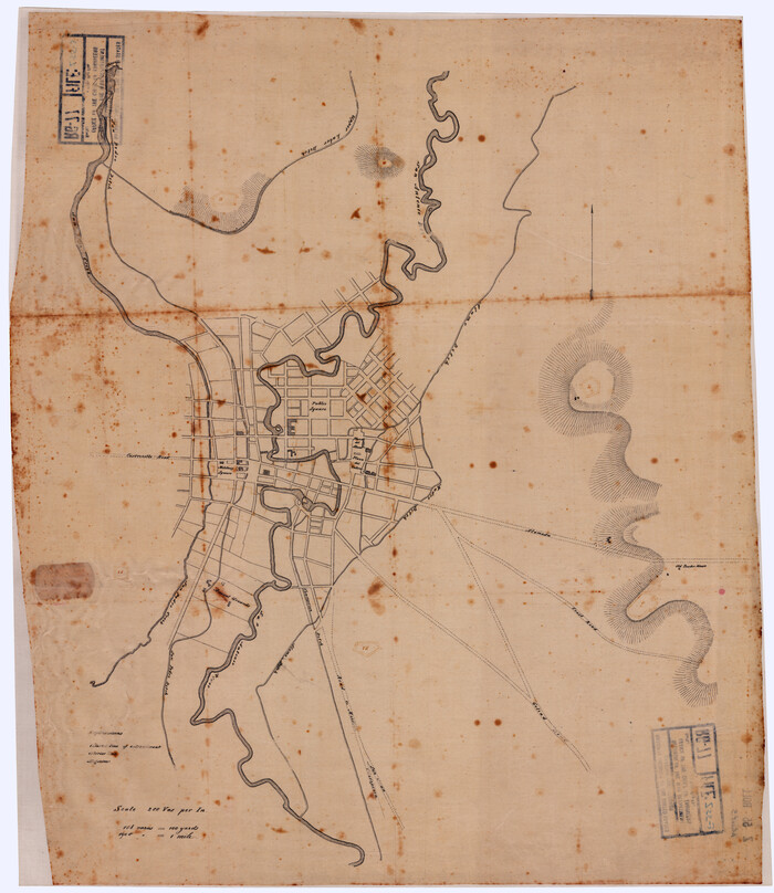
Map of Galveston, Texas, Showing the Rebel Line of Works. Surveyed and Drawn by Order of G.L. Gillespie, Brevet Major and Chief Engr., Mil. Div. of the Gulf, Under the Direction of Lt. S.E. McGregory, Comdg. Topl. Party, by Pl. St. Vignes, Asst.

Print $20.00
Map of Galveston, Texas, Showing the Rebel Line of Works. Surveyed and Drawn by Order of G.L. Gillespie, Brevet Major and Chief Engr., Mil. Div. of the Gulf, Under the Direction of Lt. S.E. McGregory, Comdg. Topl. Party, by Pl. St. Vignes, Asst.
1861
Size: 25.3 x 38.7 inches
88594
Map of Pass Cavallo, Texas, Showing the position of the Rebel fortifications and rifle pits.

Print $20.00
Map of Pass Cavallo, Texas, Showing the position of the Rebel fortifications and rifle pits.
1863
Size: 23.8 x 21.0 inches
88595
Eastern and Central Texas, Prepared by Order of Maj. Gen. N.P. Banks. Major D.C. Houston, Chief of Engineers

Print $20.00
Eastern and Central Texas, Prepared by Order of Maj. Gen. N.P. Banks. Major D.C. Houston, Chief of Engineers
1864
Size: 32.6 x 23.7 inches
88596
Map of Works of Defense near Gonzales, Tex.

Print $20.00
Map of Works of Defense near Gonzales, Tex.
1863
Size: 17.1 x 21.8 inches
88598
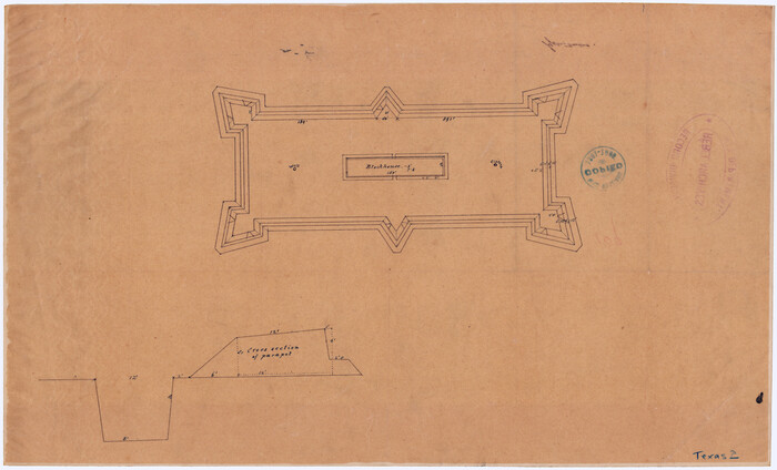
[Plan for Fort Waul near Gonzales, Texas]
Print $20.00
[Plan for Fort Waul near Gonzales, Texas]
1863
Size: 12.3 x 20.3 inches
88600
[Map of Area near Alamo showing proposed fortifications]
Print $20.00
[Map of Area near Alamo showing proposed fortifications]
1863
Size: 31.9 x 27.7 inches
88603
Topographical Map of the country between San Antonio & Colorado Rivers in the State of Texas.

Print $40.00
Topographical Map of the country between San Antonio & Colorado Rivers in the State of Texas.
1864
Size: 53.3 x 69.2 inches
88604
Topographical Map of the country between San Antonio & Colorado Rivers in the State of Texas.

Print $40.00
Topographical Map of the country between San Antonio & Colorado Rivers in the State of Texas.
1864
Size: 53.4 x 69.8 inches
88605
Topographical Map of the country between San Antonio & Colorado Rivers in the State of Texas.

Print $40.00
Topographical Map of the country between San Antonio & Colorado Rivers in the State of Texas.
1864
Size: 53.2 x 74.8 inches
88606
Reconnoissance of Sabine River and Vicinty

Print $20.00
Reconnoissance of Sabine River and Vicinty
1863
Size: 30.4 x 42.3 inches
97497
Reconnoissance of Sabine River and Valley

Print $20.00
Reconnoissance of Sabine River and Valley
1863
Size: 30.4 x 42.5 inches
97498
Reconnoissance of Sabine River and Valley

Print $20.00
Reconnoissance of Sabine River and Valley
1863
Size: 30.2 x 42.3 inches
97499
Reconnoissance of Sabine River and Valley

Print $20.00
Reconnoissance of Sabine River and Valley
1863
Size: 42.5 x 30.3 inches
97500
Reconnoissance of Sabine River and Valley

Print $20.00
Reconnoissance of Sabine River and Valley
1863
Size: 42.3 x 30.0 inches
97501
Texas Coast Showing Points of Occupation of Expedition Under Maj. Gen. N.P. Banks, Novr. 1863
Print $20.00
Texas Coast Showing Points of Occupation of Expedition Under Maj. Gen. N.P. Banks, Novr. 1863
1863
-
Size
16.0 x 17.1 inches
-
Map/Doc
88593
-
Creation Date
1863
Map of Galveston, Texas, Showing the Rebel Line of Works. Surveyed and Drawn by Order of G.L. Gillespie, Brevet Major and Chief Engr., Mil. Div. of the Gulf, Under the Direction of Lt. S.E. McGregory, Comdg. Topl. Party, by Pl. St. Vignes, Asst.
Print $20.00
Map of Galveston, Texas, Showing the Rebel Line of Works. Surveyed and Drawn by Order of G.L. Gillespie, Brevet Major and Chief Engr., Mil. Div. of the Gulf, Under the Direction of Lt. S.E. McGregory, Comdg. Topl. Party, by Pl. St. Vignes, Asst.
1861
-
Size
25.3 x 38.7 inches
-
Map/Doc
88594
-
Creation Date
1861
Map of Pass Cavallo, Texas, Showing the position of the Rebel fortifications and rifle pits.
Print $20.00
Map of Pass Cavallo, Texas, Showing the position of the Rebel fortifications and rifle pits.
1863
-
Size
23.8 x 21.0 inches
-
Map/Doc
88595
-
Creation Date
1863
Eastern and Central Texas, Prepared by Order of Maj. Gen. N.P. Banks. Major D.C. Houston, Chief of Engineers
Print $20.00
Eastern and Central Texas, Prepared by Order of Maj. Gen. N.P. Banks. Major D.C. Houston, Chief of Engineers
1864
-
Size
32.6 x 23.7 inches
-
Map/Doc
88596
-
Creation Date
1864
Map of Works of Defense near Gonzales, Tex.
Print $20.00
Map of Works of Defense near Gonzales, Tex.
1863
-
Size
17.1 x 21.8 inches
-
Map/Doc
88598
-
Creation Date
1863
[Plan for Fort Waul near Gonzales, Texas]
Print $20.00
[Plan for Fort Waul near Gonzales, Texas]
1863
-
Size
12.3 x 20.3 inches
-
Map/Doc
88600
-
Creation Date
1863
Galveston, Texas

Print $20.00
Galveston, Texas
1864
-
Size
25.7 x 32.7 inches
-
Map/Doc
88601
-
Creation Date
1864
[Map of Area near Alamo showing proposed fortifications]
Print $20.00
[Map of Area near Alamo showing proposed fortifications]
1863
-
Size
31.9 x 27.7 inches
-
Map/Doc
88603
-
Creation Date
1863
Topographical Map of the country between San Antonio & Colorado Rivers in the State of Texas.
Print $40.00
Topographical Map of the country between San Antonio & Colorado Rivers in the State of Texas.
1864
-
Size
53.3 x 69.2 inches
-
Map/Doc
88604
-
Creation Date
1864
Topographical Map of the country between San Antonio & Colorado Rivers in the State of Texas.
Print $40.00
Topographical Map of the country between San Antonio & Colorado Rivers in the State of Texas.
1864
-
Size
53.4 x 69.8 inches
-
Map/Doc
88605
-
Creation Date
1864
Topographical Map of the country between San Antonio & Colorado Rivers in the State of Texas.
Print $40.00
Topographical Map of the country between San Antonio & Colorado Rivers in the State of Texas.
1864
-
Size
53.2 x 74.8 inches
-
Map/Doc
88606
-
Creation Date
1864
Reconnoissance of Sabine River and Vicinty
Print $20.00
Reconnoissance of Sabine River and Vicinty
1863
-
Size
30.4 x 42.3 inches
-
Map/Doc
97497
-
Creation Date
1863
Reconnoissance of Sabine River and Valley
Print $20.00
Reconnoissance of Sabine River and Valley
1863
-
Size
30.4 x 42.5 inches
-
Map/Doc
97498
-
Creation Date
1863
Reconnoissance of Sabine River and Valley
Print $20.00
Reconnoissance of Sabine River and Valley
1863
-
Size
30.2 x 42.3 inches
-
Map/Doc
97499
-
Creation Date
1863
Reconnoissance of Sabine River and Valley
Print $20.00
Reconnoissance of Sabine River and Valley
1863
-
Size
42.5 x 30.3 inches
-
Map/Doc
97500
-
Creation Date
1863
Reconnoissance of Sabine River and Valley
Print $20.00
Reconnoissance of Sabine River and Valley
1863
-
Size
42.3 x 30.0 inches
-
Map/Doc
97501
-
Creation Date
1863