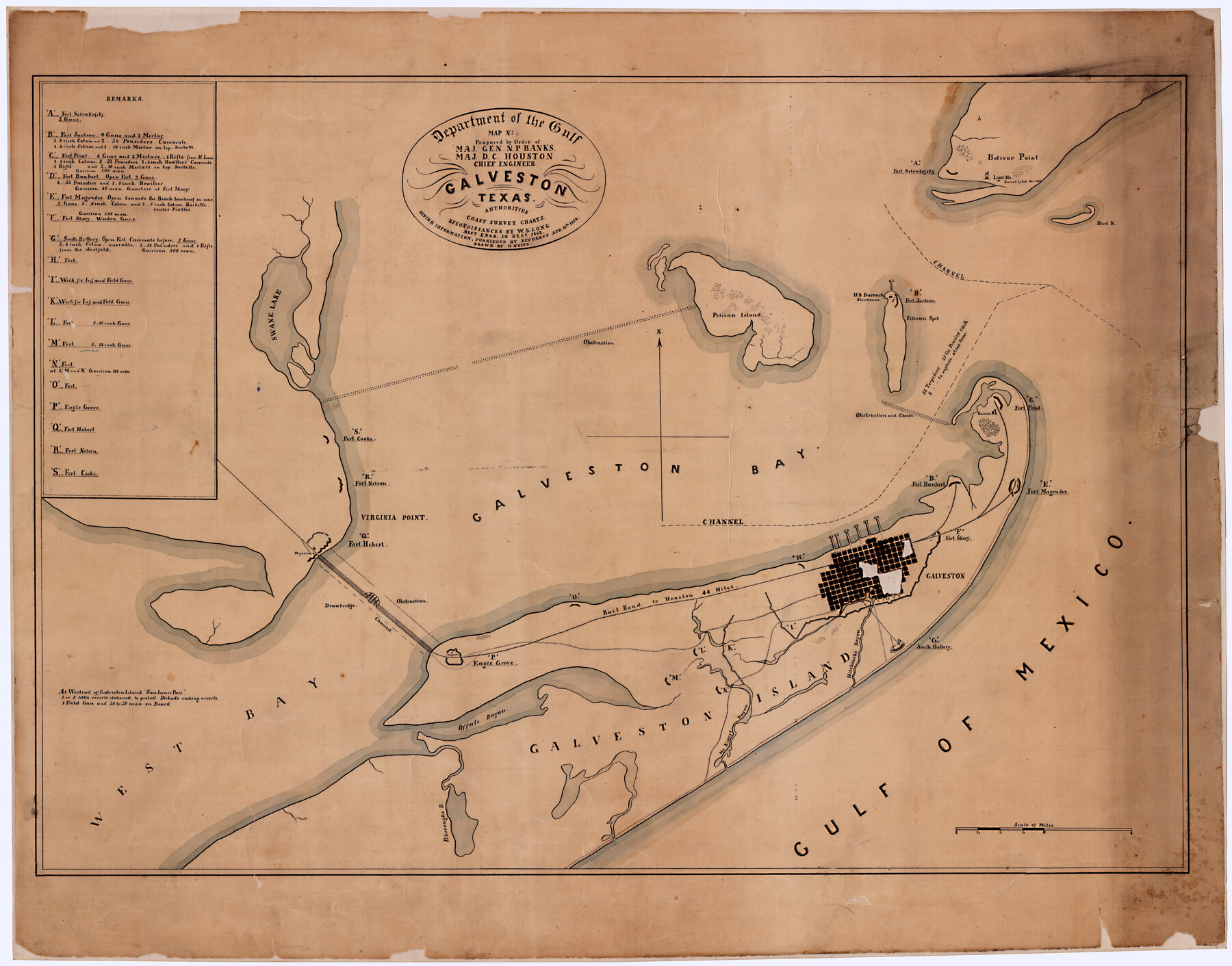
Galveston, Texas
Prepared by Order of Maj. Gen. N.P. Banks, Maj. D.C. Houston, Chief Engineer. Reconnoissances by W.S. Long, Asst. Engr., in Decr. 1862, giving information furnished by refugees, Apr. 15th, 1864
-
Map/Doc
88601
-
Collection
National Archives Digital Map Collection
-
Object Dates
1864 (Creation Date)
-
People and Organizations
Department of the Gulf (Publisher)
H. Holtz (Draftsman)
N.P. Banks (Military Officer)
D.C. Houston (Surveyor/Engineer)
W.S. Long (Surveyor/Engineer)
-
Counties
Galveston
-
Subjects
City Military
-
Height x Width
25.7 x 32.7 inches
65.3 x 83.1 cm
-
Comments
Positions of forts and batteries are located by letters keyed to a list of remarks giving the armament of the major forts.
Item is located at the National Archives, NA Identifier: 305663
Part of: National Archives Digital Map Collection
Reconnoissance of Sabine River and Valley

Print $20.00
Reconnoissance of Sabine River and Valley
1863
Size 42.3 x 30.0 inches
Map/Doc 97501
Reconnoissance of Sabine River and Valley

Print $20.00
Reconnoissance of Sabine River and Valley
1863
Size 30.2 x 42.3 inches
Map/Doc 97499
Reconnoissance of Sabine River and Vicinty

Print $20.00
Reconnoissance of Sabine River and Vicinty
1863
Size 30.4 x 42.3 inches
Map/Doc 97497
Topographical Map of the country between San Antonio & Colorado Rivers in the State of Texas.

Print $40.00
Topographical Map of the country between San Antonio & Colorado Rivers in the State of Texas.
1864
Size 53.4 x 69.8 inches
Map/Doc 88605
Reconnoissance of Sabine River and Valley

Print $20.00
Reconnoissance of Sabine River and Valley
1863
Size 30.4 x 42.5 inches
Map/Doc 97498

Map of Galveston, Texas, Showing the Rebel Line of Works. Surveyed and Drawn by Order of G.L. Gillespie, Brevet Major and Chief Engr., Mil. Div. of the Gulf, Under the Direction of Lt. S.E. McGregory, Comdg. Topl. Party, by Pl. St. Vignes, Asst.

Print $20.00
Map of Galveston, Texas, Showing the Rebel Line of Works. Surveyed and Drawn by Order of G.L. Gillespie, Brevet Major and Chief Engr., Mil. Div. of the Gulf, Under the Direction of Lt. S.E. McGregory, Comdg. Topl. Party, by Pl. St. Vignes, Asst.
1861
Size 25.3 x 38.7 inches
Map/Doc 88594
Topographical Map of the country between San Antonio & Colorado Rivers in the State of Texas.

Print $40.00
Topographical Map of the country between San Antonio & Colorado Rivers in the State of Texas.
1864
Size 53.3 x 69.2 inches
Map/Doc 88604
[Map of Area near Alamo showing proposed fortifications]
![88603, [Map of Area near Alamo showing proposed fortifications], National Archives Digital Map Collection](https://historictexasmaps.com/wmedia_w700/maps/88603.tif.jpg)
Print $20.00
[Map of Area near Alamo showing proposed fortifications]
1863
Size 31.9 x 27.7 inches
Map/Doc 88603
Reconnoissance of Sabine River and Valley

Print $20.00
Reconnoissance of Sabine River and Valley
1863
Size 42.5 x 30.3 inches
Map/Doc 97500
Texas Coast Showing Points of Occupation of Expedition Under Maj. Gen. N.P. Banks, Novr. 1863

Print $20.00
Texas Coast Showing Points of Occupation of Expedition Under Maj. Gen. N.P. Banks, Novr. 1863
1863
Size 16.0 x 17.1 inches
Map/Doc 88593
Map of Works of Defense near Gonzales, Tex.

Print $20.00
Map of Works of Defense near Gonzales, Tex.
1863
Size 17.1 x 21.8 inches
Map/Doc 88598
You may also like
Flight Mission No. CLL-11AA, Frame 172, Willacy County

Print $20.00
- Digital $50.00
Flight Mission No. CLL-11AA, Frame 172, Willacy County
1962
Size 18.4 x 18.2 inches
Map/Doc 87091
Hockley County Sketch File 14

Print $20.00
- Digital $50.00
Hockley County Sketch File 14
1911
Size 26.5 x 17.5 inches
Map/Doc 11773
Map of the Surveyed Part of Young District

Print $40.00
- Digital $50.00
Map of the Surveyed Part of Young District
1860
Size 56.3 x 32.6 inches
Map/Doc 87373
Pecos County Working Sketch 142

Print $40.00
- Digital $50.00
Pecos County Working Sketch 142
2007
Size 38.0 x 63.4 inches
Map/Doc 88610
Midland County Working Sketch 19a

Print $20.00
- Digital $50.00
Midland County Working Sketch 19a
Size 20.2 x 23.4 inches
Map/Doc 71000
Callahan County, Texas

Print $20.00
- Digital $50.00
Callahan County, Texas
1880
Size 24.1 x 18.5 inches
Map/Doc 89276
Runnels County Sketch File 3

Print $4.00
Runnels County Sketch File 3
1871
Size 13.0 x 8.1 inches
Map/Doc 35432
Bee County Sketch File 4

Print $6.00
- Digital $50.00
Bee County Sketch File 4
1858
Size 16.7 x 10.0 inches
Map/Doc 14268
Hamilton County Sketch File A

Print $4.00
- Digital $50.00
Hamilton County Sketch File A
1879
Size 9.1 x 8.2 inches
Map/Doc 24948
Lee County Working Sketch 8

Print $20.00
- Digital $50.00
Lee County Working Sketch 8
1979
Size 27.8 x 37.1 inches
Map/Doc 70387
Flight Mission No. BRE-2P, Frame 123, Nueces County

Print $20.00
- Digital $50.00
Flight Mission No. BRE-2P, Frame 123, Nueces County
1956
Size 18.5 x 22.4 inches
Map/Doc 86799
Loving County State of Texas

Print $20.00
- Digital $50.00
Loving County State of Texas
1889
Size 20.5 x 24.5 inches
Map/Doc 4581