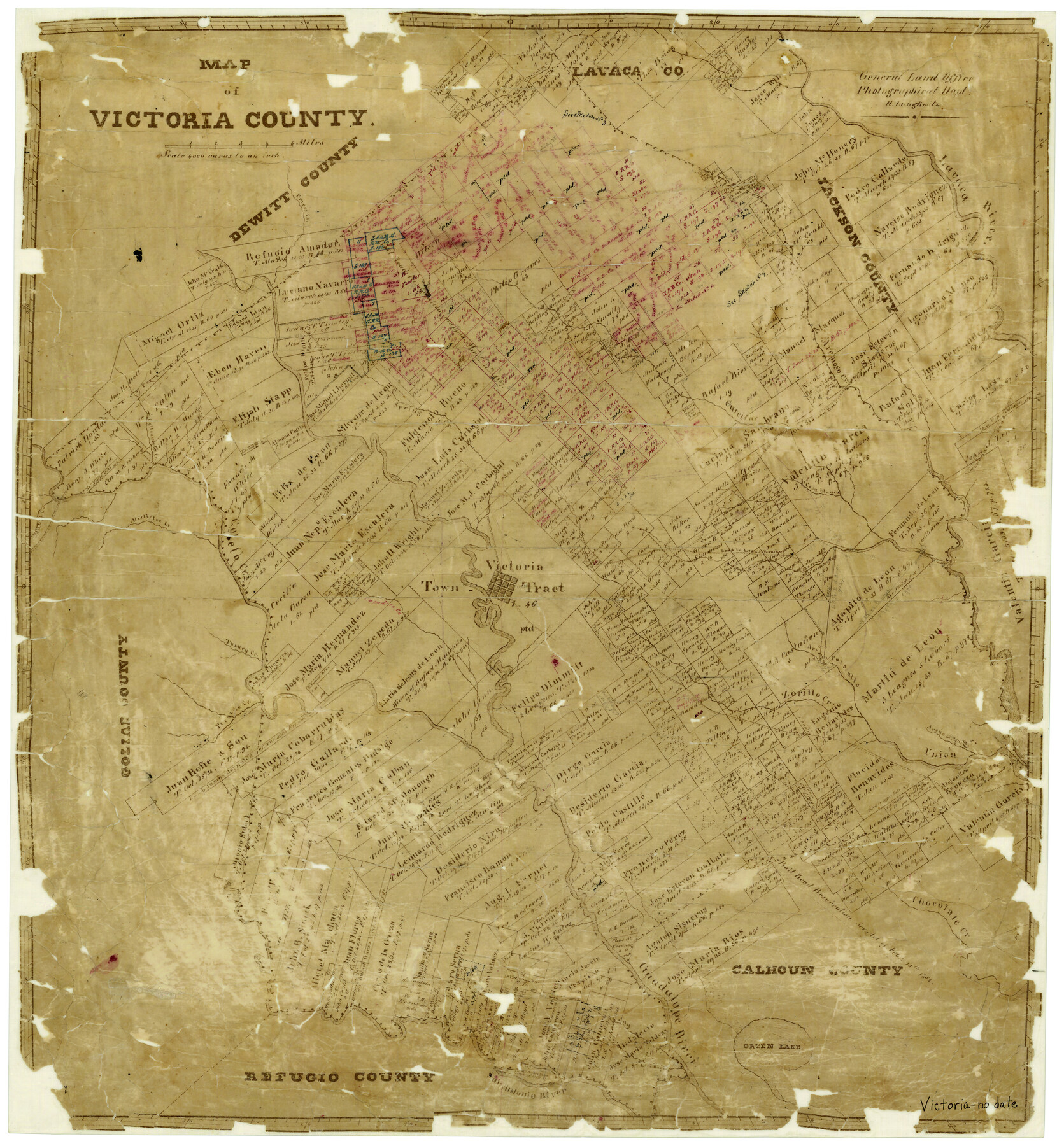
Map of Victoria County
-
Map/Doc
4639
-
Collection
General Map Collection
-
Object Dates
1873 (Creation Date)
-
People and Organizations
Herman Lungkwitz (Draftsman)
-
Counties
Victoria
-
Subjects
County
-
Height x Width
20.9 x 19.3 inches
53.1 x 49.0 cm
-
Features
Copadero Creek
Union Creek
Chicolete Creek
Texana Road
Old Stanton Road
San Felipe Road
San Antonio River
Elm Bayou
Green Lake
Guadalupe River
Chocolate Creek
Perdido Creek
Arroyo del Aguila
Zorillo Creek
Arroyo Palo Alto
South Chicolete Creek
Turkey Creek
Victoria
Marcado Creek
Road to Leon's Rancho
Casablanca Creek
Coleto Creek
Mistletoe Creek
Milby Creek
Cottonwood Creek
Spring Creek
Garcitas Creek
Arenoso Creek
Prices Creek
Lavaca River
Part of: General Map Collection
Kenedy County Rolled Sketch 10

Print $20.00
- Digital $50.00
Kenedy County Rolled Sketch 10
1915
Size 21.7 x 35.7 inches
Map/Doc 6470
Jasper County Sketch File 25

Print $16.00
- Digital $50.00
Jasper County Sketch File 25
1941
Size 14.2 x 8.7 inches
Map/Doc 27826
Brewster County Rolled Sketch 73

Print $20.00
- Digital $50.00
Brewster County Rolled Sketch 73
1938
Size 19.7 x 23.3 inches
Map/Doc 5239
Intracoastal Waterway in Texas - Corpus Christi to Point Isabel including Arroyo Colorado to Mo. Pac. R.R. Bridge Near Harlingen

Print $20.00
- Digital $50.00
Intracoastal Waterway in Texas - Corpus Christi to Point Isabel including Arroyo Colorado to Mo. Pac. R.R. Bridge Near Harlingen
1933
Size 28.2 x 40.8 inches
Map/Doc 61852
Flight Mission No. BQR-22K, Frame 35, Brazoria County

Print $20.00
- Digital $50.00
Flight Mission No. BQR-22K, Frame 35, Brazoria County
1953
Size 18.7 x 22.5 inches
Map/Doc 84119
Titus County Working Sketch 2

Print $20.00
- Digital $50.00
Titus County Working Sketch 2
Size 23.6 x 25.3 inches
Map/Doc 69363
Wichita County Sketch File A

Print $4.00
- Digital $50.00
Wichita County Sketch File A
1861
Size 7.8 x 10.3 inches
Map/Doc 40036
[Surveys along the San Gabriel River]
![78375, [Surveys along the San Gabriel River], General Map Collection](https://historictexasmaps.com/wmedia_w700/maps/78375.tif.jpg)
Print $2.00
- Digital $50.00
[Surveys along the San Gabriel River]
Size 9.0 x 6.3 inches
Map/Doc 78375
Terrell County Working Sketch 33

Print $20.00
- Digital $50.00
Terrell County Working Sketch 33
1945
Size 16.1 x 31.6 inches
Map/Doc 62125
Jeff Davis County Working Sketch 32

Print $40.00
- Digital $50.00
Jeff Davis County Working Sketch 32
1975
Size 66.7 x 43.7 inches
Map/Doc 66527
Shelby County Sketch File 8

Print $4.00
- Digital $50.00
Shelby County Sketch File 8
Size 10.1 x 7.9 inches
Map/Doc 36607
Map of Lee County Texas

Print $20.00
- Digital $50.00
Map of Lee County Texas
1879
Size 26.2 x 18.0 inches
Map/Doc 4578
You may also like
San Jacinto River, Houston Ship Channel

Print $2.00
- Digital $50.00
San Jacinto River, Houston Ship Channel
1939
Size 11.7 x 17.7 inches
Map/Doc 65150
Terrell County Sketch File 33

Print $20.00
- Digital $50.00
Terrell County Sketch File 33
1924
Size 18.2 x 27.6 inches
Map/Doc 12427
Loving County Working Sketch 16a

Print $20.00
- Digital $50.00
Loving County Working Sketch 16a
1976
Size 45.4 x 29.3 inches
Map/Doc 70650
Sutton County Working Sketch 61

Print $20.00
- Digital $50.00
Sutton County Working Sketch 61
1959
Size 44.1 x 38.6 inches
Map/Doc 62404
Pressler's Map of the State of Texas

Print $40.00
Pressler's Map of the State of Texas
1858
Size 48.0 x 52.5 inches
Map/Doc 76232
Kaufman County Working Sketch 9

Print $20.00
- Digital $50.00
Kaufman County Working Sketch 9
1988
Size 35.9 x 29.8 inches
Map/Doc 66672
El Paso County Rolled Sketch RJ

Print $40.00
- Digital $50.00
El Paso County Rolled Sketch RJ
1919
Size 56.7 x 27.2 inches
Map/Doc 8865
Tyler County Working Sketch 17

Print $20.00
- Digital $50.00
Tyler County Working Sketch 17
1962
Size 33.1 x 38.9 inches
Map/Doc 69487
Rand McNally Standard Map of Texas

Print $20.00
Rand McNally Standard Map of Texas
1923
Size 27.6 x 40.3 inches
Map/Doc 76261

Garza County Rolled Sketch J

Print $20.00
- Digital $50.00
Garza County Rolled Sketch J
1911
Size 27.2 x 23.4 inches
Map/Doc 6004
Working Sketch in Hockley, Lamb, and Lubbock Counties

Print $20.00
- Digital $50.00
Working Sketch in Hockley, Lamb, and Lubbock Counties
1911
Size 16.7 x 26.6 inches
Map/Doc 92213