Terrell County Sketch File 33
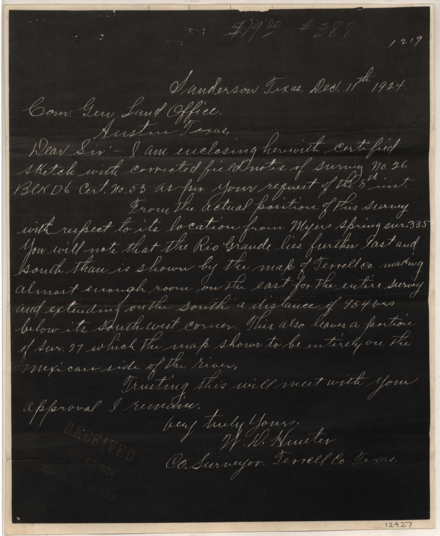
[Statement and sketch of connecting line from M. K. & T. E. Ry. Block D-6 and E. L. & R. R. Ry. Block D-7 to Meyer's Springs]
-
Map/Doc
12427
-
Collection
General Map Collection
-
Object Dates
12/11/1924 (Creation Date)
8/13/1953 (File Date)
-
People and Organizations
W.D. Hunter (Surveyor/Engineer)
-
Counties
Terrell
-
Subjects
Surveying Sketch File
-
Height x Width
18.2 x 27.6 inches
46.2 x 70.1 cm
-
Medium
photostat, negative
-
Features
Myers Spring
Rio Grande
Part of: General Map Collection
Medina County Working Sketch Graphic Index

Print $40.00
- Digital $50.00
Medina County Working Sketch Graphic Index
1976
Size 52.8 x 42.8 inches
Map/Doc 76639
Plan of the City of Galveston, Texas

Print $20.00
- Digital $50.00
Plan of the City of Galveston, Texas
1845
Size 18.2 x 27.7 inches
Map/Doc 62967
Briscoe County Sketch File A-1

Print $16.00
- Digital $50.00
Briscoe County Sketch File A-1
1894
Size 10.7 x 8.4 inches
Map/Doc 16399
Austin County Working Sketch 8

Print $20.00
- Digital $50.00
Austin County Working Sketch 8
1992
Size 28.7 x 31.6 inches
Map/Doc 67249
Delta County Sketch File 4

Print $4.00
- Digital $50.00
Delta County Sketch File 4
Size 10.9 x 7.3 inches
Map/Doc 20674
Cottle County Working Sketch 10

Print $20.00
- Digital $50.00
Cottle County Working Sketch 10
1937
Size 18.1 x 15.6 inches
Map/Doc 68320
Nueces County Sketch File 12

Print $4.00
- Digital $50.00
Nueces County Sketch File 12
1848
Size 9.8 x 8.7 inches
Map/Doc 32528
Val Verde County Sketch File 43

Print $20.00
- Digital $50.00
Val Verde County Sketch File 43
1938
Size 24.8 x 32.3 inches
Map/Doc 12585
Shackelford County Sketch File 5

Print $4.00
- Digital $50.00
Shackelford County Sketch File 5
1885
Size 12.3 x 7.6 inches
Map/Doc 36578
Pecos County Sketch File 2

Print $20.00
- Digital $50.00
Pecos County Sketch File 2
1880
Size 12.7 x 8.2 inches
Map/Doc 33652
Deaf Smith County

Print $40.00
- Digital $50.00
Deaf Smith County
1926
Size 39.0 x 50.5 inches
Map/Doc 73128
Galveston County NRC Article 33.136 Location Key Sheet

Print $20.00
- Digital $50.00
Galveston County NRC Article 33.136 Location Key Sheet
1994
Size 27.0 x 22.0 inches
Map/Doc 77015
You may also like
Plano General de la Ciudad de Mexico. Levantado Por el Teniente Coronel Don Diego Garcia Conde en el Año de 1793. Aumentado y corregido en lo mas notable Por el Teniente Coronel retirado, Don Rafael Maria Calvo En el de 1830

Print $20.00
- Digital $50.00
Plano General de la Ciudad de Mexico. Levantado Por el Teniente Coronel Don Diego Garcia Conde en el Año de 1793. Aumentado y corregido en lo mas notable Por el Teniente Coronel retirado, Don Rafael Maria Calvo En el de 1830
1793
Size 19.7 x 21.8 inches
Map/Doc 95354
General Highway Map, Garza County, Texas

Print $20.00
General Highway Map, Garza County, Texas
1940
Size 18.1 x 24.6 inches
Map/Doc 79098
Hudspeth County Working Sketch 39

Print $20.00
- Digital $50.00
Hudspeth County Working Sketch 39
1980
Size 37.1 x 37.0 inches
Map/Doc 66324
Parker County Sketch File 32

Print $6.00
- Digital $50.00
Parker County Sketch File 32
Size 11.0 x 12.2 inches
Map/Doc 33574
Terlingua Special Map, The University of Texas Mineral Survey, Brewster County, Texas

Print $20.00
- Digital $50.00
Terlingua Special Map, The University of Texas Mineral Survey, Brewster County, Texas
1902
Size 20.4 x 22.6 inches
Map/Doc 482
Victoria County Rolled Sketch 4A

Print $40.00
- Digital $50.00
Victoria County Rolled Sketch 4A
Size 66.4 x 43.9 inches
Map/Doc 10095
The Chief Justice County of Bexar. Lands in Conflict with Milam County

Print $20.00
The Chief Justice County of Bexar. Lands in Conflict with Milam County
2020
Size 14.6 x 21.6 inches
Map/Doc 96039
Loving County Working Sketch 20

Print $40.00
- Digital $50.00
Loving County Working Sketch 20
1979
Size 30.6 x 56.6 inches
Map/Doc 70654
Reeves County Rolled Sketch 8

Print $40.00
- Digital $50.00
Reeves County Rolled Sketch 8
Size 22.6 x 64.6 inches
Map/Doc 9848
Henderson County Rolled Sketch 9

Print $40.00
- Digital $50.00
Henderson County Rolled Sketch 9
1963
Size 51.9 x 33.8 inches
Map/Doc 9165
Connected Map of Austin's Colony

Print $20.00
- Digital $50.00
Connected Map of Austin's Colony
1833
Size 38.1 x 36.1 inches
Map/Doc 88999
Roberts County Working Sketch 5

Print $20.00
- Digital $50.00
Roberts County Working Sketch 5
1949
Size 40.4 x 40.1 inches
Map/Doc 63531