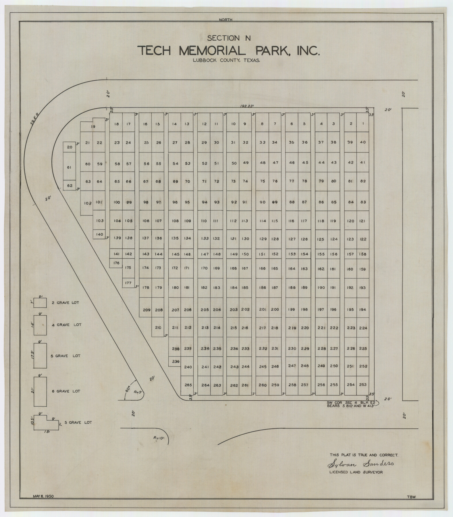
Section N Tech Memorial Park, Inc.
-
Map/Doc
92307
-
Collection
Twichell Survey Records
-
Object Dates
5/6/1950 (Creation Date)
-
People and Organizations
Sylvan Sanders (Surveyor/Engineer)
-
Counties
Lubbock
-
Height x Width
16.6 x 18.8 inches
42.2 x 47.8 cm
Part of: Twichell Survey Records
General Highway Map, Floyd County, Texas

Print $20.00
- Digital $50.00
General Highway Map, Floyd County, Texas
1950
Size 18.8 x 25.7 inches
Map/Doc 92973
[University Lands Block 16 and Blocks 194, Z and part of 12]
![91618, [University Lands Block 16 and Blocks 194, Z and part of 12], Twichell Survey Records](https://historictexasmaps.com/wmedia_w700/maps/91618-1.tif.jpg)
Print $20.00
- Digital $50.00
[University Lands Block 16 and Blocks 194, Z and part of 12]
1911
Size 32.2 x 23.3 inches
Map/Doc 91618
[Blocks A, RG, O, B, S and 11]
![92858, [Blocks A, RG, O, B, S and 11], Twichell Survey Records](https://historictexasmaps.com/wmedia_w700/maps/92858-1.tif.jpg)
Print $20.00
- Digital $50.00
[Blocks A, RG, O, B, S and 11]
1921
Size 25.2 x 15.5 inches
Map/Doc 92858
Val Verde County, Texas, Block D-7, E. L. & R. R. Ry. showing connecting line with Meyer's Spring and the N.W. corner Block D-8, E. L. & R. R. Ry. Co.

Print $20.00
- Digital $50.00
Val Verde County, Texas, Block D-7, E. L. & R. R. Ry. showing connecting line with Meyer's Spring and the N.W. corner Block D-8, E. L. & R. R. Ry. Co.
1938
Size 26.7 x 18.7 inches
Map/Doc 91949
Map of the CB Live Stock Co. -N- Ranch situated in Crosby County, Texas

Print $20.00
- Digital $50.00
Map of the CB Live Stock Co. -N- Ranch situated in Crosby County, Texas
1907
Size 41.4 x 38.0 inches
Map/Doc 89919
[Worksheets related to the Wilson Strickland survey and vicinity]
![91266, [Vicinity and related to the Wilson Strickland Survey], Twichell Survey Records](https://historictexasmaps.com/wmedia_w700/maps/91266-1.tif.jpg)
Print $20.00
- Digital $50.00
[Worksheets related to the Wilson Strickland survey and vicinity]
Size 35.8 x 17.5 inches
Map/Doc 91266
[T. & P. Block 35, Townships 1N - 5N]
![93138, [T. & P. Block 35, Townships 1N - 5N], Twichell Survey Records](https://historictexasmaps.com/wmedia_w700/maps/93138-1.tif.jpg)
Print $40.00
- Digital $50.00
[T. & P. Block 35, Townships 1N - 5N]
Size 23.8 x 87.2 inches
Map/Doc 93138
[H. & T. C. RR. Company, Block 47 and vicinity]
![91159, [H. & T. C. RR. Company, Block 47 and vicinity], Twichell Survey Records](https://historictexasmaps.com/wmedia_w700/maps/91159-1.tif.jpg)
Print $20.00
- Digital $50.00
[H. & T. C. RR. Company, Block 47 and vicinity]
Size 18.7 x 19.9 inches
Map/Doc 91159
Cecil Stein Drilling Block

Print $3.00
- Digital $50.00
Cecil Stein Drilling Block
1951
Size 12.3 x 9.5 inches
Map/Doc 92280
[T. T. RR. Co. Block 8 and vicinity]
![90795, [T. T. RR. Co. Block 8 and vicinity], Twichell Survey Records](https://historictexasmaps.com/wmedia_w700/maps/90795-1.tif.jpg)
Print $20.00
- Digital $50.00
[T. T. RR. Co. Block 8 and vicinity]
Size 20.3 x 15.2 inches
Map/Doc 90795
[Sketch of counties just south of the Panhandle]
![90913, [Sketch of counties just south of the Panhandle], Twichell Survey Records](https://historictexasmaps.com/wmedia_w700/maps/90913-1.tif.jpg)
Print $20.00
- Digital $50.00
[Sketch of counties just south of the Panhandle]
Size 42.7 x 34.8 inches
Map/Doc 90913
Original Town of Nadine, Lea County, New Mexico

Print $20.00
- Digital $50.00
Original Town of Nadine, Lea County, New Mexico
Size 27.1 x 33.5 inches
Map/Doc 92420
You may also like
[Sections 5 through 34]
![92480, [Sections 5 through 34], Twichell Survey Records](https://historictexasmaps.com/wmedia_w700/maps/92480-1.tif.jpg)
Print $20.00
- Digital $50.00
[Sections 5 through 34]
Size 23.9 x 19.4 inches
Map/Doc 92480
Kimble County Working Sketch 14

Print $20.00
- Digital $50.00
Kimble County Working Sketch 14
1923
Size 17.2 x 13.2 inches
Map/Doc 70082

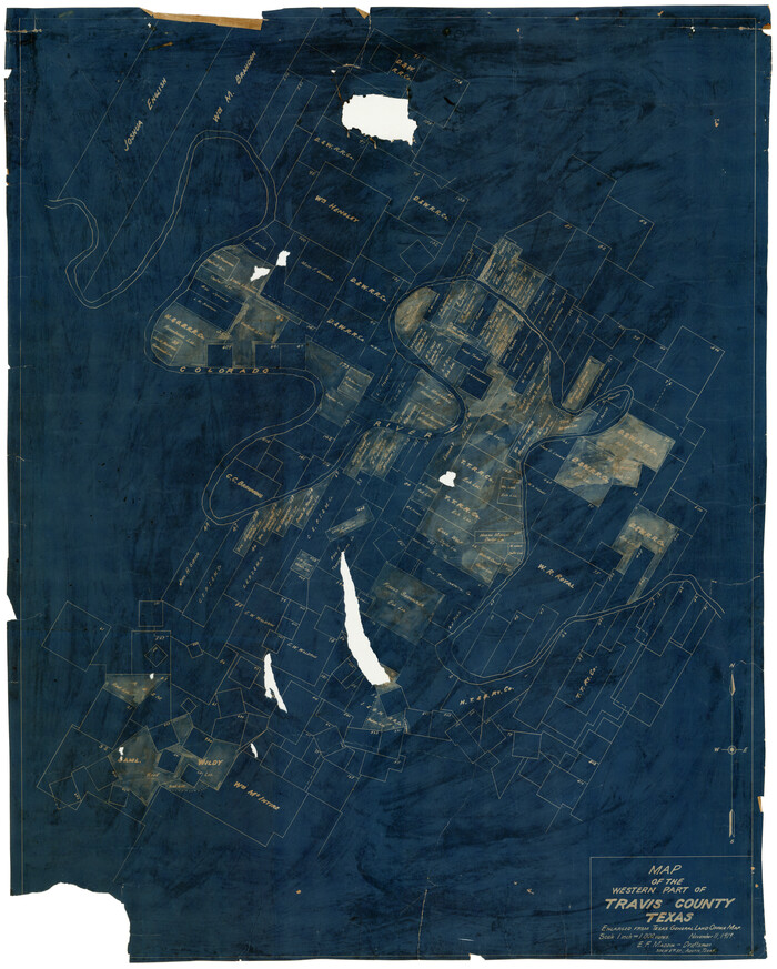
Map of the Western Part of Travis County, Texas
Print $20.00
- Digital $50.00
Map of the Western Part of Travis County, Texas
1919
Size 36.2 x 29.9 inches
Map/Doc 10754
Uvalde County Sketch File 16a

Print $6.00
- Digital $50.00
Uvalde County Sketch File 16a
Size 11.0 x 13.4 inches
Map/Doc 38995
Duval County Sketch File 15

Print $4.00
- Digital $50.00
Duval County Sketch File 15
Size 12.0 x 9.0 inches
Map/Doc 21309
Brazos County Sketch File 4

Print $4.00
- Digital $50.00
Brazos County Sketch File 4
1928
Size 11.5 x 7.3 inches
Map/Doc 15557
McCulloch County Working Sketch Graphic Index

Print $20.00
- Digital $50.00
McCulloch County Working Sketch Graphic Index
1949
Size 47.3 x 37.4 inches
Map/Doc 76636
Polk County Working Sketch 3

Print $40.00
- Digital $50.00
Polk County Working Sketch 3
1911
Size 25.4 x 56.0 inches
Map/Doc 71618
Map of Travis County

Print $40.00
- Digital $50.00
Map of Travis County
1895
Size 48.8 x 54.1 inches
Map/Doc 82083
[East Line & Red River Railroad from Sulphur Springs to Jefferson]
![64768, [East Line & Red River Railroad from Sulphur Springs to Jefferson], General Map Collection](https://historictexasmaps.com/wmedia_w700/maps/64768.tif.jpg)
Print $40.00
- Digital $50.00
[East Line & Red River Railroad from Sulphur Springs to Jefferson]
1879
Size 38.0 x 108.5 inches
Map/Doc 64768
[H. & T. C. Block 47 and part of G. & M. Block 3]
![91817, [H. & T. C. Block 47 and part of G. & M. Block 3], Twichell Survey Records](https://historictexasmaps.com/wmedia_w700/maps/91817-1.tif.jpg)
Print $20.00
- Digital $50.00
[H. & T. C. Block 47 and part of G. & M. Block 3]
Size 29.4 x 27.9 inches
Map/Doc 91817