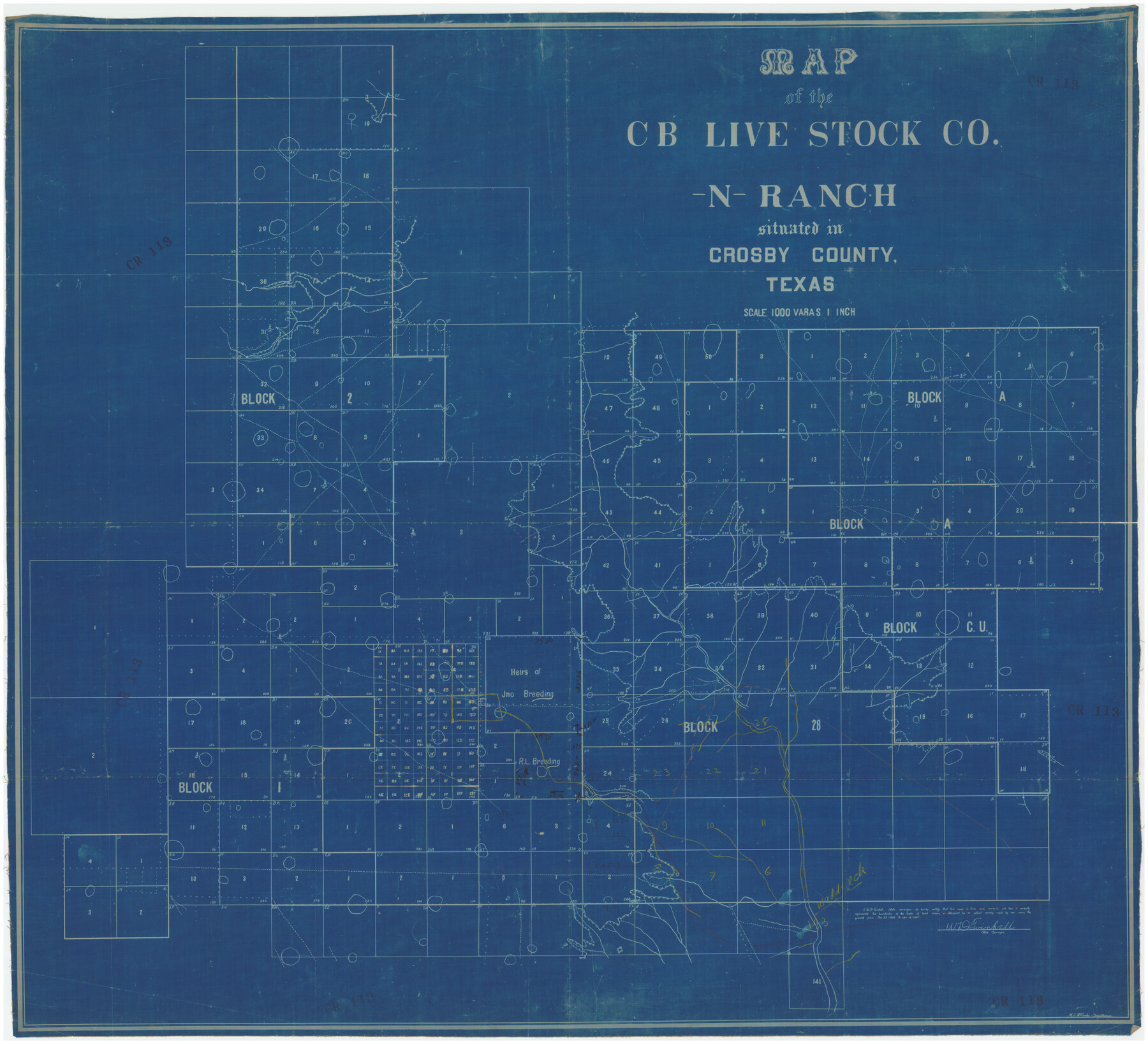
Map of the CB Live Stock Co. -N- Ranch situated in Crosby County, Texas
CR113
-
Map/Doc
89919
-
Collection
Twichell Survey Records
-
Object Dates
1907 (Creation Date)
-
People and Organizations
M.J. McCombs (Draftsman)
W.D. Twichell (Surveyor/Engineer)
-
Counties
Crosby
-
Height x Width
41.4 x 38.0 inches
105.2 x 96.5 cm
Part of: Twichell Survey Records
[Leagues 7, 8, 9, and 10]
![92220, [Leagues 7, 8, 9, and 10], Twichell Survey Records](https://historictexasmaps.com/wmedia_w700/maps/92220-1.tif.jpg)
Print $20.00
- Digital $50.00
[Leagues 7, 8, 9, and 10]
1943
Size 18.3 x 12.2 inches
Map/Doc 92220
[A. B. & M. Block 2]
![91794, [A. B. & M. Block 2], Twichell Survey Records](https://historictexasmaps.com/wmedia_w700/maps/91794-1.tif.jpg)
Print $2.00
- Digital $50.00
[A. B. & M. Block 2]
Size 7.1 x 14.1 inches
Map/Doc 91794
[Northwest part of County]
![90865, [Northwest part of County], Twichell Survey Records](https://historictexasmaps.com/wmedia_w700/maps/90865-2.tif.jpg)
Print $20.00
- Digital $50.00
[Northwest part of County]
Size 32.3 x 22.3 inches
Map/Doc 90865
Working Sketch in Archer County

Print $20.00
- Digital $50.00
Working Sketch in Archer County
1924
Size 30.8 x 42.3 inches
Map/Doc 90175
[Northwest Garza County around John Walker and Thomas Hughes surveys]
![90848, [Northwest Garza County around John Walker and Thomas Hughes surveys], Twichell Survey Records](https://historictexasmaps.com/wmedia_w700/maps/90848-2.tif.jpg)
Print $20.00
- Digital $50.00
[Northwest Garza County around John Walker and Thomas Hughes surveys]
1913
Size 27.5 x 14.3 inches
Map/Doc 90848
[West Central Portion of County]
![91257, [West Central Portion of County], Twichell Survey Records](https://historictexasmaps.com/wmedia_w700/maps/91257-1.tif.jpg)
Print $20.00
- Digital $50.00
[West Central Portion of County]
Size 19.5 x 9.8 inches
Map/Doc 91257
Working Sketch in Randall and Swisher Cos.

Print $2.00
- Digital $50.00
Working Sketch in Randall and Swisher Cos.
Size 5.8 x 4.1 inches
Map/Doc 93047
Subdivision of Sutton County School League 175, Bailey County, Texas

Print $2.00
- Digital $50.00
Subdivision of Sutton County School League 175, Bailey County, Texas
1929
Size 8.9 x 11.5 inches
Map/Doc 90201
Pecos County Sketch showing location of oil wells within 1/2 mile radius of the south 8 acres of the Bob Reid survey

Print $20.00
- Digital $50.00
Pecos County Sketch showing location of oil wells within 1/2 mile radius of the south 8 acres of the Bob Reid survey
Size 24.1 x 20.5 inches
Map/Doc 91624
[Leagues 571- 575, 578- 583, 603- 609, and Surrounding Surveys]
![91065, [Leagues 571- 575, 578- 583, 603- 609, and Surrounding Surveys], Twichell Survey Records](https://historictexasmaps.com/wmedia_w700/maps/91065-1.tif.jpg)
Print $20.00
- Digital $50.00
[Leagues 571- 575, 578- 583, 603- 609, and Surrounding Surveys]
Size 43.2 x 12.5 inches
Map/Doc 91065
![91783, [Block M-19], Twichell Survey Records](https://historictexasmaps.com/wmedia_w700/maps/91783-1.tif.jpg)
Leila Y. Post Montgomery & Marjorie Post Hutton's Subdivision of Hall County School Land Leagues 158-159-N 1/2 157, Cochran County, Texas

Print $20.00
- Digital $50.00
Leila Y. Post Montgomery & Marjorie Post Hutton's Subdivision of Hall County School Land Leagues 158-159-N 1/2 157, Cochran County, Texas
Size 8.4 x 18.4 inches
Map/Doc 90456
You may also like
Brazoria County Working Sketch 26

Print $20.00
- Digital $50.00
Brazoria County Working Sketch 26
1968
Size 33.2 x 35.4 inches
Map/Doc 67511
Terrell County Working Sketch 42

Print $20.00
- Digital $50.00
Terrell County Working Sketch 42
1957
Size 34.4 x 34.4 inches
Map/Doc 62135
Map of Hill County

Print $40.00
- Digital $50.00
Map of Hill County
1884
Size 80.0 x 36.8 inches
Map/Doc 93378
Haskell County Rolled Sketch 3

Print $20.00
- Digital $50.00
Haskell County Rolled Sketch 3
1902
Size 18.1 x 21.0 inches
Map/Doc 6164
Jackson County Sketch File 31

Print $18.00
- Digital $50.00
Jackson County Sketch File 31
1940
Size 14.4 x 8.4 inches
Map/Doc 27756
Flight Mission No. CUG-3P, Frame 18, Kleberg County

Print $20.00
- Digital $50.00
Flight Mission No. CUG-3P, Frame 18, Kleberg County
1956
Size 18.5 x 22.3 inches
Map/Doc 86228
Lipscomb County Working Sketch 3

Print $20.00
- Digital $50.00
Lipscomb County Working Sketch 3
1965
Size 27.8 x 46.1 inches
Map/Doc 70579
Dimmit County Sketch File 28

Print $40.00
- Digital $50.00
Dimmit County Sketch File 28
Size 14.7 x 17.4 inches
Map/Doc 11350
Houston County Sketch File 39

Print $6.00
- Digital $50.00
Houston County Sketch File 39
1845
Size 17.0 x 10.9 inches
Map/Doc 26824
Texas Boundary Line

Print $20.00
- Digital $50.00
Texas Boundary Line
Size 21.4 x 11.8 inches
Map/Doc 92076
1882 Map of the Texas & Pacific R-Y Reserve

Print $40.00
- Digital $50.00
1882 Map of the Texas & Pacific R-Y Reserve
1888
Size 95.6 x 42.5 inches
Map/Doc 2299
Sketch Showing Original Corners and Connections Affecting Blocks T1, T2, and T3 in Lamb & Castro Counties

Print $20.00
- Digital $50.00
Sketch Showing Original Corners and Connections Affecting Blocks T1, T2, and T3 in Lamb & Castro Counties
Size 26.5 x 46.0 inches
Map/Doc 90405