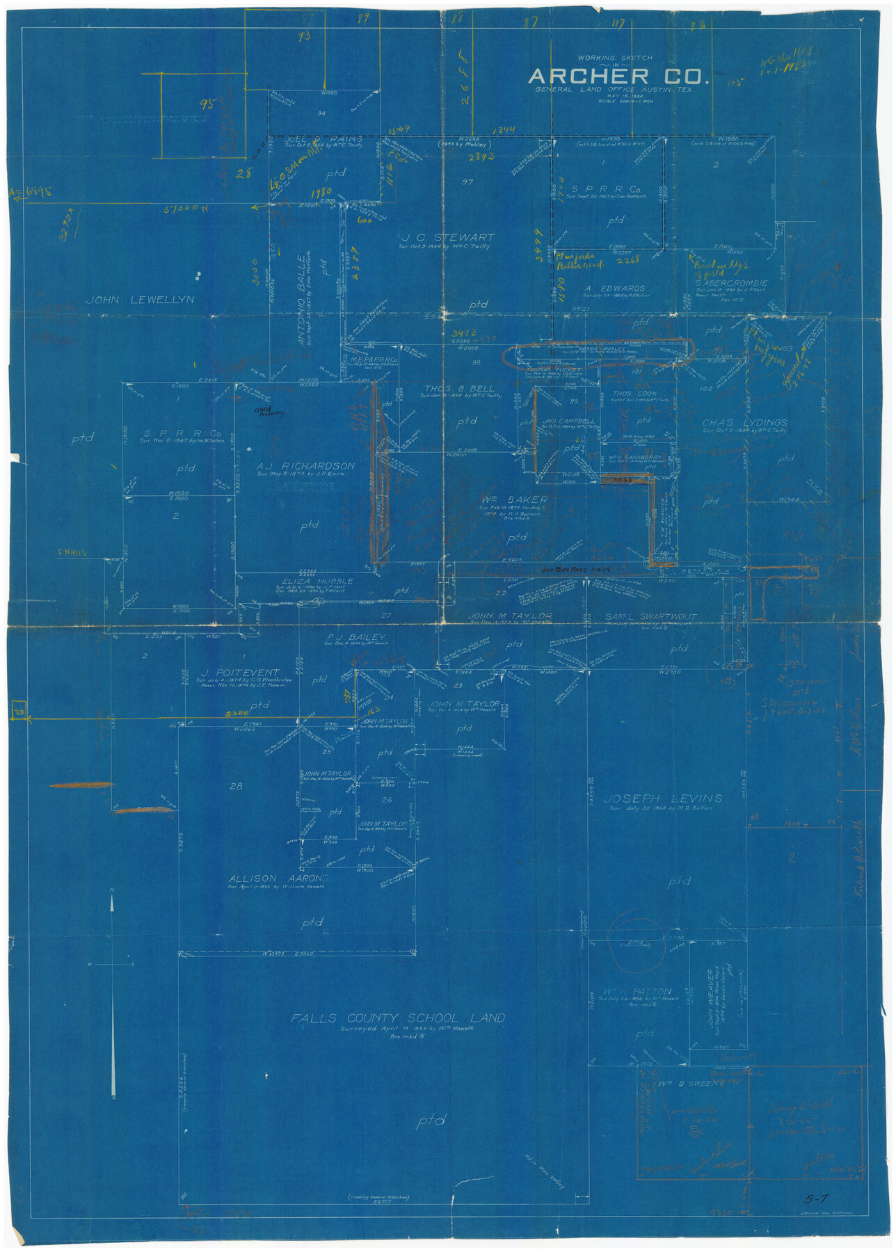
Working Sketch in Archer County
5-7
-
Map/Doc
90175
-
Collection
Twichell Survey Records
-
Object Dates
5/15/1924 (Creation Date)
-
People and Organizations
J. Bascom Giles (Draftsman)
-
Counties
Archer
-
Height x Width
30.8 x 42.3 inches
78.2 x 107.4 cm
Part of: Twichell Survey Records
Section M, Tech Memorial Park, Inc.

Print $2.00
- Digital $50.00
Section M, Tech Memorial Park, Inc.
1950
Size 7.6 x 11.8 inches
Map/Doc 92271
[H. & G. N. RR. Co. Block 1]
![90890, [H. & G. N. RR. Co. Block 1], Twichell Survey Records](https://historictexasmaps.com/wmedia_w700/maps/90890-1.tif.jpg)
Print $20.00
- Digital $50.00
[H. & G. N. RR. Co. Block 1]
Size 17.1 x 28.0 inches
Map/Doc 90890
[Part of Block JK4 and A1]
![90784, [Part of Block JK4 and A1], Twichell Survey Records](https://historictexasmaps.com/wmedia_w700/maps/90784-1.tif.jpg)
Print $3.00
- Digital $50.00
[Part of Block JK4 and A1]
Size 17.0 x 11.2 inches
Map/Doc 90784
Ellwood Place, Installment No. 3

Print $20.00
- Digital $50.00
Ellwood Place, Installment No. 3
Size 17.8 x 24.9 inches
Map/Doc 92791
[I. & G. N. RR. Co. Block I]
![89828, [I. &G. N. RR. Co. Block I], Twichell Survey Records](https://historictexasmaps.com/wmedia_w700/maps/89828-1.tif.jpg)
Print $20.00
- Digital $50.00
[I. & G. N. RR. Co. Block I]
Size 43.0 x 31.7 inches
Map/Doc 89828
[Sketch showing Blocks M-20 and M-22]
![91722, [Sketch showing Blocks M-20 and M-22], Twichell Survey Records](https://historictexasmaps.com/wmedia_w700/maps/91722-1.tif.jpg)
Print $20.00
- Digital $50.00
[Sketch showing Blocks M-20 and M-22]
Size 15.0 x 19.5 inches
Map/Doc 91722
[Map showing J. H. Gibson Blocks D and DD]
![92000, [Map showing J. H. Gibson Blocks D and DD], Twichell Survey Records](https://historictexasmaps.com/wmedia_w700/maps/92000-1.tif.jpg)
Print $20.00
- Digital $50.00
[Map showing J. H. Gibson Blocks D and DD]
Size 26.1 x 18.8 inches
Map/Doc 92000
[Sections 302-313 and sections south of Blocks D and AX]
![92017, [Sections 302-313 and sections south of Blocks D and AX], Twichell Survey Records](https://historictexasmaps.com/wmedia_w700/maps/92017-1.tif.jpg)
Print $20.00
- Digital $50.00
[Sections 302-313 and sections south of Blocks D and AX]
Size 17.5 x 35.6 inches
Map/Doc 92017
R. H. Fulton Lands

Print $20.00
- Digital $50.00
R. H. Fulton Lands
Size 39.9 x 14.3 inches
Map/Doc 92509
The California Case

Print $20.00
- Digital $50.00
The California Case
Size 17.6 x 12.5 inches
Map/Doc 91696
Hill Ranch, Gaines County, Texas

Print $20.00
- Digital $50.00
Hill Ranch, Gaines County, Texas
1951
Size 21.2 x 16.6 inches
Map/Doc 92680
[T. & N. O. Railroad Company Blocks 2T and 3T]
![91489, [T. & N. O. Railroad Company Blocks 2T and 3T], Twichell Survey Records](https://historictexasmaps.com/wmedia_w700/maps/91489-1.tif.jpg)
Print $20.00
- Digital $50.00
[T. & N. O. Railroad Company Blocks 2T and 3T]
Size 24.4 x 8.8 inches
Map/Doc 91489
You may also like
Refugio County Boundary File 3

Print $4.00
- Digital $50.00
Refugio County Boundary File 3
Size 14.0 x 8.7 inches
Map/Doc 58244
[Sketch for Mineral Application 17237 / Mineral File 11855 - Neches River, Joe A. Sanders]
![2819, [Sketch for Mineral Application 17237 / Mineral File 11855 - Neches River, Joe A. Sanders], General Map Collection](https://historictexasmaps.com/wmedia_w700/maps/2819.tif.jpg)
Print $2.00
- Digital $50.00
[Sketch for Mineral Application 17237 / Mineral File 11855 - Neches River, Joe A. Sanders]
1927
Size 12.8 x 8.2 inches
Map/Doc 2819
Pecos County Rolled Sketch 160

Print $20.00
- Digital $50.00
Pecos County Rolled Sketch 160
Size 43.0 x 36.9 inches
Map/Doc 9739
Childress County Rolled Sketch 5

Print $20.00
- Digital $50.00
Childress County Rolled Sketch 5
1913
Size 31.2 x 24.7 inches
Map/Doc 5439
Fort Bend County Sketch File 6

Print $2.00
- Digital $50.00
Fort Bend County Sketch File 6
Size 4.7 x 8.4 inches
Map/Doc 22891
Haskell County

Print $20.00
- Digital $50.00
Haskell County
1888
Size 38.5 x 37.1 inches
Map/Doc 4700
Austin Map and Street Guide [Verso]
![94163, Austin Map and Street Guide [Verso], General Map Collection](https://historictexasmaps.com/wmedia_w700/maps/94163.tif.jpg)
Austin Map and Street Guide [Verso]
1986
Size 35.5 x 22.8 inches
Map/Doc 94163
Parker County Sketch File 27

Print $20.00
- Digital $50.00
Parker County Sketch File 27
1876
Size 23.7 x 23.8 inches
Map/Doc 12146
Pecos County Working Sketch 115

Print $40.00
- Digital $50.00
Pecos County Working Sketch 115
1973
Size 54.6 x 31.8 inches
Map/Doc 71588
Cooke County Sketch File 25

Print $4.00
- Digital $50.00
Cooke County Sketch File 25
1872
Size 8.2 x 6.8 inches
Map/Doc 19275
Howard County Rolled Sketch 8

Print $20.00
- Digital $50.00
Howard County Rolled Sketch 8
Size 16.8 x 40.2 inches
Map/Doc 6237
Gray County Working Sketch 7

Print $20.00
- Digital $50.00
Gray County Working Sketch 7
1971
Size 41.3 x 28.7 inches
Map/Doc 63238