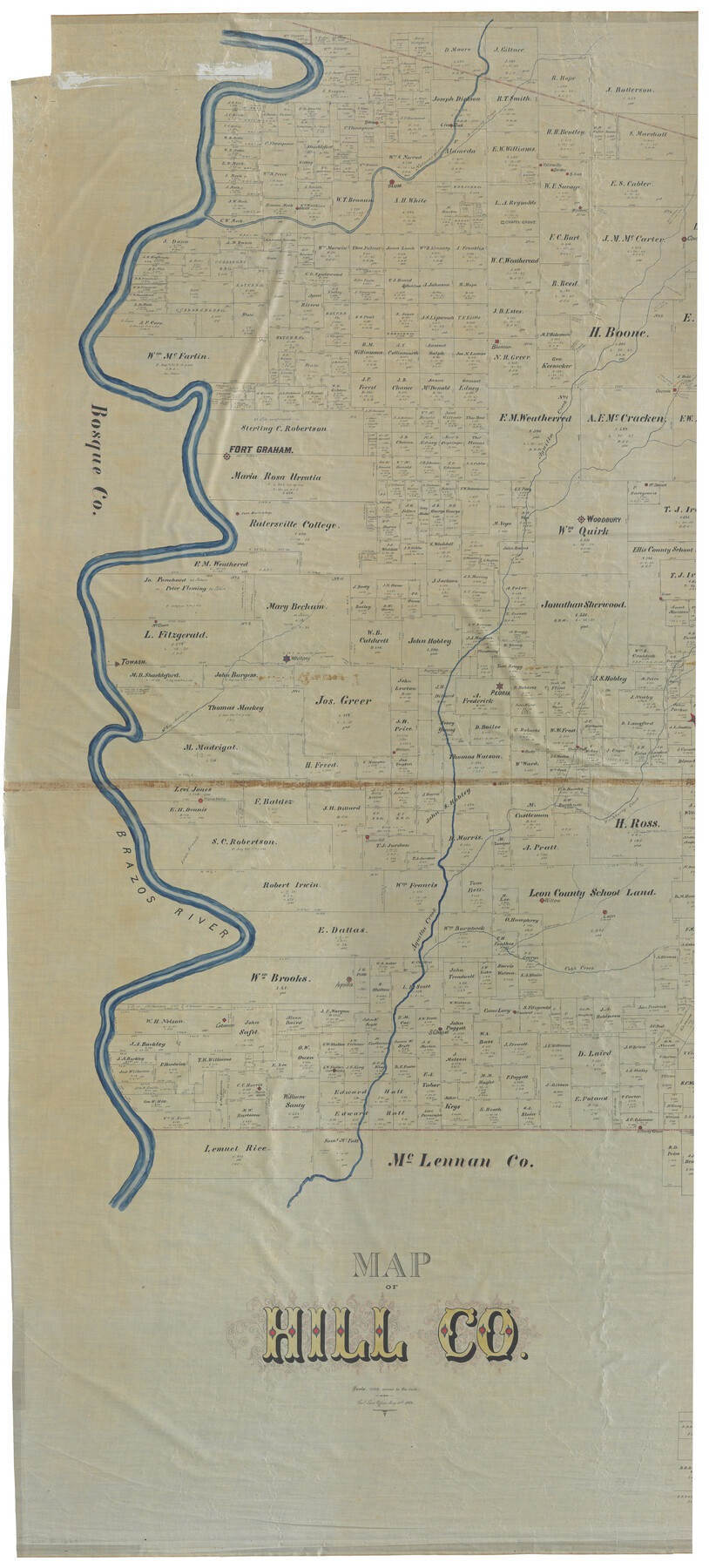
Map of Hill County
-
Map/Doc
93378
-
Collection
General Map Collection
-
Object Dates
5/30/1884 (Creation Date)
-
People and Organizations
Texas General Land Office (Publisher)
-
Counties
Hill
-
Subjects
County
-
Height x Width
80.0 x 36.8 inches
203.2 x 93.5 cm
-
Comments
West half of map. For east half see map 93379. For digital composite of both halves see map 82049.
Related maps
Map of Hill County

Print $40.00
- Digital $50.00
Map of Hill County
1884
Size 80.1 x 68.0 inches
Map/Doc 82049
Map of Hill County

Print $40.00
- Digital $50.00
Map of Hill County
1884
Size 80.0 x 35.2 inches
Map/Doc 93379
Part of: General Map Collection
Fractional Township No. 8 South Range No. 16 East of the Indian Meridian, Indian Territory

Print $20.00
- Digital $50.00
Fractional Township No. 8 South Range No. 16 East of the Indian Meridian, Indian Territory
1896
Size 19.3 x 24.3 inches
Map/Doc 75228
Potter County Boundary File 2

Print $30.00
- Digital $50.00
Potter County Boundary File 2
Size 9.0 x 6.0 inches
Map/Doc 57952
Knox County Working Sketch 13

Print $3.00
- Digital $50.00
Knox County Working Sketch 13
1953
Size 9.6 x 11.0 inches
Map/Doc 70255
Montague County Sketch File 21

Print $4.00
- Digital $50.00
Montague County Sketch File 21
1888
Size 12.4 x 8.3 inches
Map/Doc 31751
La Salle County Working Sketch 29

Print $20.00
- Digital $50.00
La Salle County Working Sketch 29
1955
Size 25.8 x 27.4 inches
Map/Doc 70330
Rusk County Working Sketch 20b

Print $20.00
- Digital $50.00
Rusk County Working Sketch 20b
1955
Size 31.5 x 30.3 inches
Map/Doc 63656
Jefferson County Aerial Photograph Index Sheet 5

Print $20.00
- Digital $50.00
Jefferson County Aerial Photograph Index Sheet 5
1953
Size 23.3 x 16.9 inches
Map/Doc 83709
Kent County Working Sketch Graphic Index

Print $20.00
- Digital $50.00
Kent County Working Sketch Graphic Index
1971
Size 44.7 x 37.0 inches
Map/Doc 76604
Val Verde County Working Sketch 101

Print $20.00
- Digital $50.00
Val Verde County Working Sketch 101
1981
Size 29.1 x 25.4 inches
Map/Doc 72236
Jefferson County Rolled Sketch 63

Print $20.00
- Digital $50.00
Jefferson County Rolled Sketch 63
1884
Size 26.5 x 36.4 inches
Map/Doc 6417

Baylor County Sketch File 16

Print $6.00
- Digital $50.00
Baylor County Sketch File 16
1879
Size 9.5 x 6.2 inches
Map/Doc 14186
You may also like
Orange County Working Sketch 2

Print $20.00
- Digital $50.00
Orange County Working Sketch 2
1917
Size 12.8 x 13.1 inches
Map/Doc 71334
Briscoe County Working Sketch 9

Print $20.00
- Digital $50.00
Briscoe County Working Sketch 9
1951
Size 24.9 x 36.7 inches
Map/Doc 67812
[Sketch for Mineral Application 35981 - Liberty County, John Mecom]
![65618, [Sketch for Mineral Application 35981 - Liberty County, John Mecom], General Map Collection](https://historictexasmaps.com/wmedia_w700/maps/65618.tif.jpg)
Print $20.00
- Digital $50.00
[Sketch for Mineral Application 35981 - Liberty County, John Mecom]
1941
Size 30.1 x 26.4 inches
Map/Doc 65618

Flight Mission No. DCL-7C, Frame 3, Kenedy County

Print $20.00
- Digital $50.00
Flight Mission No. DCL-7C, Frame 3, Kenedy County
1943
Size 18.5 x 22.3 inches
Map/Doc 85995
Morton, Cochran County, Texas / Morton Cemetery First Addition, Cochran County, Texas

Print $20.00
- Digital $50.00
Morton, Cochran County, Texas / Morton Cemetery First Addition, Cochran County, Texas
Size 30.8 x 34.6 inches
Map/Doc 92542
Martin County Working Sketch 15

Print $20.00
- Digital $50.00
Martin County Working Sketch 15
1975
Size 23.9 x 19.5 inches
Map/Doc 70833
Morris County Rolled Sketch 2A

Print $20.00
- Digital $50.00
Morris County Rolled Sketch 2A
Size 24.0 x 18.8 inches
Map/Doc 10254
University of Texas System University Lands

Print $20.00
- Digital $50.00
University of Texas System University Lands
1936
Size 23.2 x 17.6 inches
Map/Doc 93236
Flight Mission No. BQR-7K, Frame 25, Brazoria County

Print $20.00
- Digital $50.00
Flight Mission No. BQR-7K, Frame 25, Brazoria County
1952
Size 18.8 x 22.3 inches
Map/Doc 84023
Hemphill County Working Sketch 17

Print $20.00
- Digital $50.00
Hemphill County Working Sketch 17
1972
Size 33.6 x 45.0 inches
Map/Doc 66112
Ward County Working Sketch 42

Print $20.00
- Digital $50.00
Ward County Working Sketch 42
1970
Size 42.2 x 41.3 inches
Map/Doc 72348