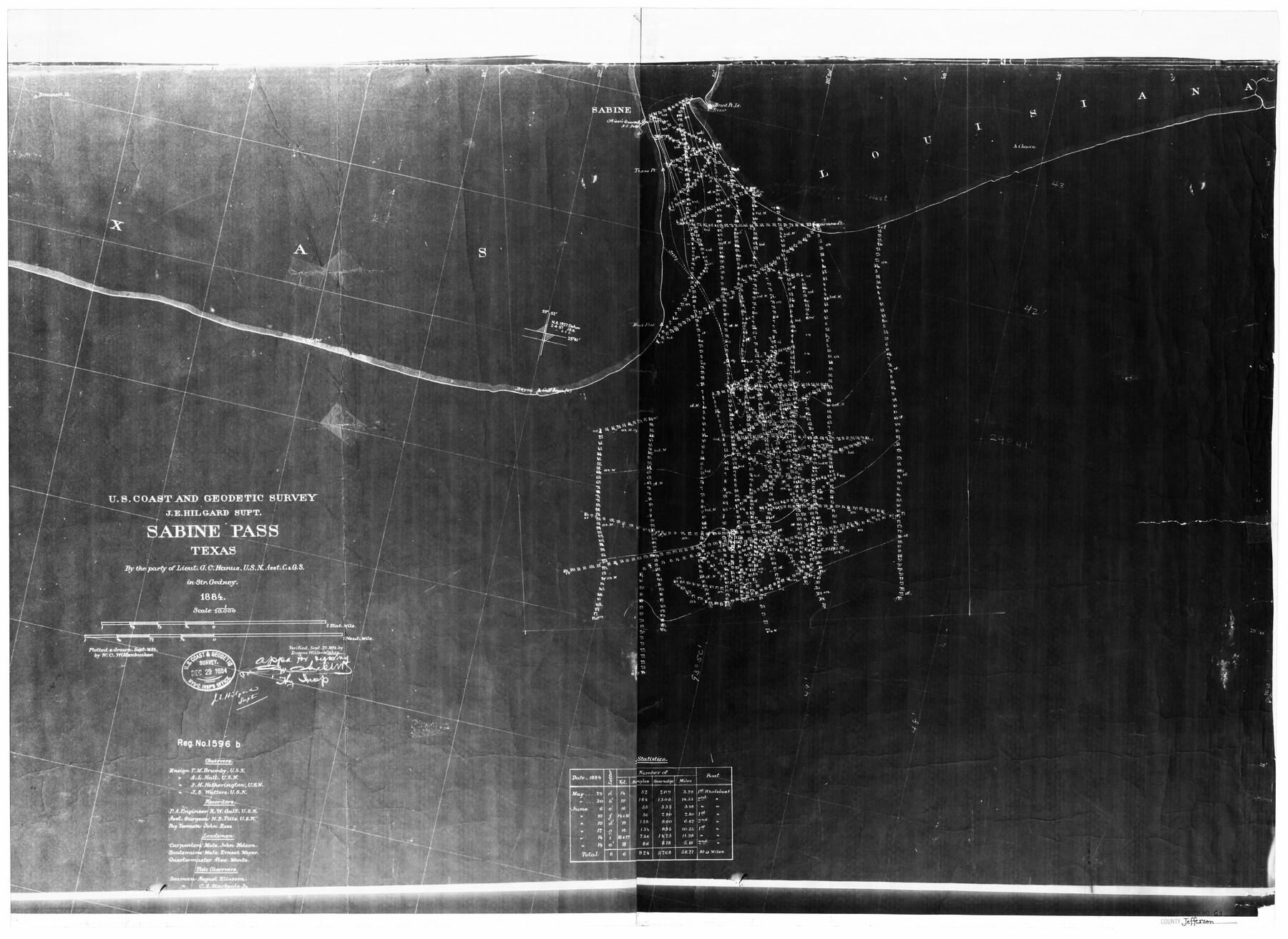
Jefferson County Rolled Sketch 63
Sabine Pass, Texas
-
Map/Doc
6417
-
Collection
General Map Collection
-
Object Dates
9/1884 (Creation Date)
5/14/1980 (File Date)
-
People and Organizations
U.S. Coast and Geodetic Survey (Publisher)
W.C. Willenbucher (Draftsman)
-
Counties
Jefferson
-
Subjects
Surveying Rolled Sketch
-
Height x Width
26.5 x 36.4 inches
67.3 x 92.5 cm
-
Medium
photostat
Part of: General Map Collection
Newton County Working Sketch 43

Print $20.00
- Digital $50.00
Newton County Working Sketch 43
1982
Size 20.7 x 28.6 inches
Map/Doc 71289
Kendall County Working Sketch 27

Print $20.00
- Digital $50.00
Kendall County Working Sketch 27
1994
Size 30.8 x 42.6 inches
Map/Doc 66699
Kimble County Working Sketch 19

Print $20.00
- Digital $50.00
Kimble County Working Sketch 19
1926
Size 38.7 x 34.8 inches
Map/Doc 70087
Flight Mission No. DQN-6K, Frame 10, Calhoun County

Print $20.00
- Digital $50.00
Flight Mission No. DQN-6K, Frame 10, Calhoun County
1953
Size 18.5 x 22.3 inches
Map/Doc 84432
Reagan County Working Sketch 29

Print $40.00
- Digital $50.00
Reagan County Working Sketch 29
1963
Size 34.3 x 66.4 inches
Map/Doc 71871
[Sabine Pass]
![73343, [Sabine Pass], General Map Collection](https://historictexasmaps.com/wmedia_w700/maps/73343.tif.jpg)
Print $20.00
- Digital $50.00
[Sabine Pass]
1916
Size 18.5 x 26.5 inches
Map/Doc 73343
Travis County Working Sketch 53

Print $40.00
- Digital $50.00
Travis County Working Sketch 53
1964
Size 42.7 x 53.0 inches
Map/Doc 69437
Hansford County

Print $20.00
- Digital $50.00
Hansford County
1932
Size 41.8 x 39.8 inches
Map/Doc 1847
[Surveys in Milam's Colony along the Colorado River and Onion Creek]
![91, [Surveys in Milam's Colony along the Colorado River and Onion Creek], General Map Collection](https://historictexasmaps.com/wmedia_w700/maps/91.tif.jpg)
Print $20.00
- Digital $50.00
[Surveys in Milam's Colony along the Colorado River and Onion Creek]
1835
Size 24.7 x 25.0 inches
Map/Doc 91
Howard County Boundary File 2c

Print $44.00
- Digital $50.00
Howard County Boundary File 2c
Size 5.0 x 8.9 inches
Map/Doc 55126
Motley County Sketch File C (N)

Print $48.00
- Digital $50.00
Motley County Sketch File C (N)
Size 7.7 x 18.4 inches
Map/Doc 31978
Map of Wilbarger County

Print $20.00
- Digital $50.00
Map of Wilbarger County
1874
Size 23.8 x 22.2 inches
Map/Doc 4147
You may also like
Flight Mission No. DCL-6C, Frame 98, Kenedy County

Print $20.00
- Digital $50.00
Flight Mission No. DCL-6C, Frame 98, Kenedy County
1943
Size 18.6 x 22.3 inches
Map/Doc 85928
Shackelford County Working Sketch 6

Print $20.00
- Digital $50.00
Shackelford County Working Sketch 6
1963
Size 26.1 x 28.9 inches
Map/Doc 63846
Denton County Working Sketch 23

Print $20.00
- Digital $50.00
Denton County Working Sketch 23
1982
Size 18.6 x 14.1 inches
Map/Doc 68628
[Sketch for Mineral Application 16787 - Pecos River Bed, A. T. Freet]
![2814, [Sketch for Mineral Application 16787 - Pecos River Bed, A. T. Freet], General Map Collection](https://historictexasmaps.com/wmedia_w700/maps/2814-1.tif.jpg)
Print $40.00
- Digital $50.00
[Sketch for Mineral Application 16787 - Pecos River Bed, A. T. Freet]
1927
Size 20.2 x 59.5 inches
Map/Doc 2814
[Texas State Capitol Land]
![89940, [Texas State Capitol Land], Twichell Survey Records](https://historictexasmaps.com/wmedia_w700/maps/89940-1.tif.jpg)
Print $40.00
- Digital $50.00
[Texas State Capitol Land]
Size 37.6 x 72.6 inches
Map/Doc 89940
Hutchinson County Rolled Sketch 44-14

Print $20.00
- Digital $50.00
Hutchinson County Rolled Sketch 44-14
2002
Size 24.0 x 36.0 inches
Map/Doc 77550
Fannin County Sketch File 19

Print $4.00
- Digital $50.00
Fannin County Sketch File 19
1878
Size 8.3 x 10.0 inches
Map/Doc 22473
Presidio County Working Sketch 125

Print $20.00
- Digital $50.00
Presidio County Working Sketch 125
1985
Size 32.7 x 27.9 inches
Map/Doc 71803
Fort Bend Co.

Print $20.00
- Digital $50.00
Fort Bend Co.
1931
Size 39.1 x 40.8 inches
Map/Doc 73150
Sketch of Roll Number for Copy of Original Field Notes Texas & Pacific Railway Reservation

Print $3.00
- Digital $50.00
Sketch of Roll Number for Copy of Original Field Notes Texas & Pacific Railway Reservation
Size 17.4 x 10.0 inches
Map/Doc 92026
Castro County Sketch File 4j

Print $4.00
- Digital $50.00
Castro County Sketch File 4j
Size 13.5 x 8.7 inches
Map/Doc 17483
Pecos County Rolled Sketch 83

Print $20.00
- Digital $50.00
Pecos County Rolled Sketch 83
1931
Size 17.6 x 26.2 inches
Map/Doc 7242