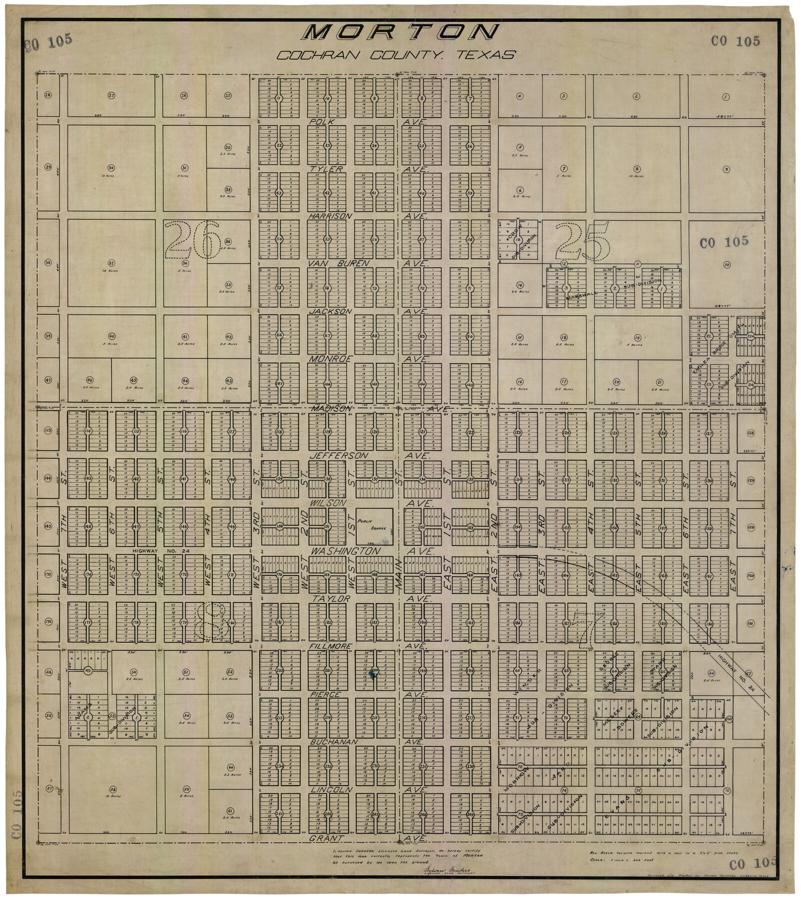
Morton, Cochran County, Texas / Morton Cemetery First Addition, Cochran County, Texas
CO105
-
Map/Doc
92542
-
Collection
Twichell Survey Records
-
People and Organizations
Sylvan Sanders (Surveyor/Engineer)
-
Counties
Cochran
-
Height x Width
30.8 x 34.6 inches
78.2 x 87.9 cm
Part of: Twichell Survey Records
[Block K5, Section 13]
![91452, [Block K5, Section 13], Twichell Survey Records](https://historictexasmaps.com/wmedia_w700/maps/91452-1.tif.jpg)
Print $20.00
- Digital $50.00
[Block K5, Section 13]
Size 22.2 x 18.5 inches
Map/Doc 91452
Purchase Area Map, Ropesville Rural Communities, Hockley County, Texas

Print $40.00
- Digital $50.00
Purchase Area Map, Ropesville Rural Communities, Hockley County, Texas
1937
Size 52.9 x 29.3 inches
Map/Doc 89681
Sketch T [showing Capitol Reserve]
![89631, Sketch T [showing Capitol Reserve], Twichell Survey Records](https://historictexasmaps.com/wmedia_w700/maps/89631-1.tif.jpg)
Print $40.00
- Digital $50.00
Sketch T [showing Capitol Reserve]
1903
Size 22.0 x 48.9 inches
Map/Doc 89631
Lamb-Bailey County Line

Print $40.00
- Digital $50.00
Lamb-Bailey County Line
Size 15.1 x 52.6 inches
Map/Doc 89636
Cogdell Ranch Kent County, Texas

Print $20.00
- Digital $50.00
Cogdell Ranch Kent County, Texas
1950
Size 24.8 x 13.5 inches
Map/Doc 92189
Sketch of the Giles Connell Ranch in Ector and Crane Counties

Print $20.00
- Digital $50.00
Sketch of the Giles Connell Ranch in Ector and Crane Counties
1918
Size 12.8 x 19.6 inches
Map/Doc 90303
[Southwest part of B. S. & F. Block and surveys to the south]
![90389, [Southwest part of B. S. & F. Block and surveys to the south], Twichell Survey Records](https://historictexasmaps.com/wmedia_w700/maps/90389-1.tif.jpg)
Print $3.00
- Digital $50.00
[Southwest part of B. S. & F. Block and surveys to the south]
Size 11.1 x 10.3 inches
Map/Doc 90389
[R. T. Bucy's Survey 3, League 321]
![91348, [R. T. Bucy's Survey 3, League 321], Twichell Survey Records](https://historictexasmaps.com/wmedia_w700/maps/91348.tif.jpg)
Digital $50.00
[R. T. Bucy's Survey 3, League 321]
Map/Doc 91348
Map Defining Three Positions for North Line of Wilson Strickland

Print $20.00
- Digital $50.00
Map Defining Three Positions for North Line of Wilson Strickland
Size 25.5 x 10.7 inches
Map/Doc 91284
Sketch in Martin County Showing Survey 13, Block X

Print $2.00
- Digital $50.00
Sketch in Martin County Showing Survey 13, Block X
1908
Size 12.6 x 8.4 inches
Map/Doc 91286
[Subdivision of Crockett County School Land Lgs. 214-217]
![90106, [Subdivision of Crockett County School Land Lgs. 214-217], Twichell Survey Records](https://historictexasmaps.com/wmedia_w700/maps/90106-1.tif.jpg)
Print $2.00
- Digital $50.00
[Subdivision of Crockett County School Land Lgs. 214-217]
Size 12.4 x 8.5 inches
Map/Doc 90106
The California Case

Print $20.00
- Digital $50.00
The California Case
Size 17.9 x 12.6 inches
Map/Doc 91697
You may also like

Cameron County Sketch File 3

Print $42.00
- Digital $50.00
Cameron County Sketch File 3
1930
Size 11.1 x 8.8 inches
Map/Doc 17023
Burnet Empresario Colony. December 22, 1826

Print $20.00
Burnet Empresario Colony. December 22, 1826
2020
Size 12.9 x 21.6 inches
Map/Doc 95985
Texas 1973 Official Highway Travel Map

Texas 1973 Official Highway Travel Map
Size 28.1 x 36.3 inches
Map/Doc 94406
Sherman County Boundary File 3

Print $55.00
- Digital $50.00
Sherman County Boundary File 3
Size 9.2 x 8.6 inches
Map/Doc 58773
Brazoria County Rolled Sketch 28

Print $40.00
- Digital $50.00
Brazoria County Rolled Sketch 28
Size 35.7 x 56.8 inches
Map/Doc 8458
Randall County Rolled Sketch 5

Print $20.00
- Digital $50.00
Randall County Rolled Sketch 5
1945
Size 29.7 x 17.6 inches
Map/Doc 7425
Right of Way and Track Map of The Wichita Falls & Southern Railroad Company

Print $40.00
- Digital $50.00
Right of Way and Track Map of The Wichita Falls & Southern Railroad Company
1942
Size 24.4 x 56.4 inches
Map/Doc 64515
Stonewall County Sketch File X

Print $20.00
- Digital $50.00
Stonewall County Sketch File X
1901
Size 25.8 x 18.1 inches
Map/Doc 12378
General Highway Map, Kinney County, Uvalde County, Texas

Print $20.00
General Highway Map, Kinney County, Uvalde County, Texas
1961
Size 18.2 x 24.6 inches
Map/Doc 79556
Plat in Pecos County, Texas

Print $40.00
- Digital $50.00
Plat in Pecos County, Texas
1927
Size 58.3 x 37.9 inches
Map/Doc 89877
Harris County Working Sketch 101

Print $20.00
- Digital $50.00
Harris County Working Sketch 101
1980
Size 32.6 x 36.2 inches
Map/Doc 65993