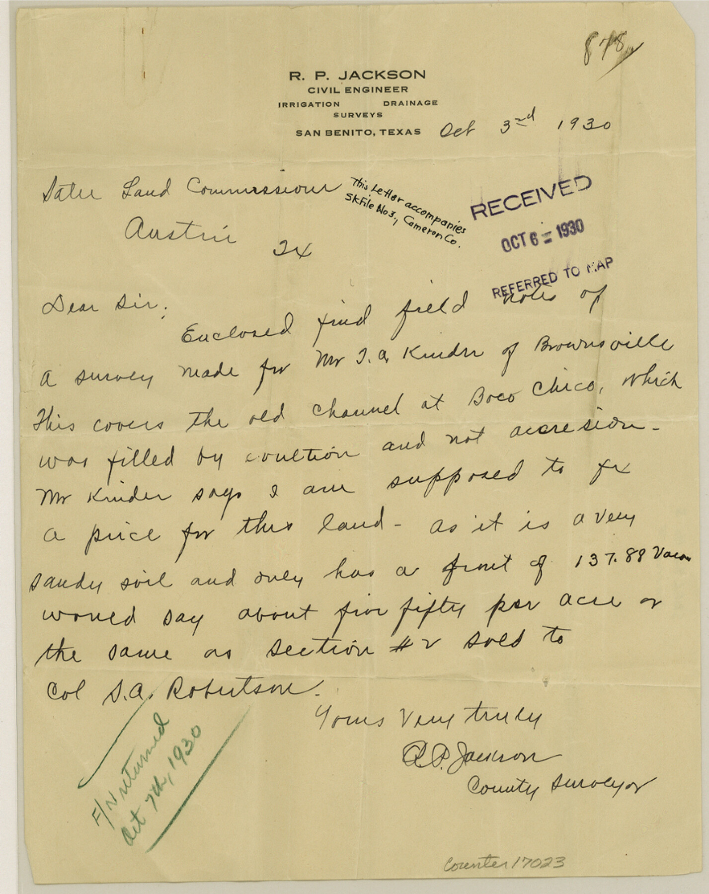
Cameron County Sketch File 3
[Letter and map of Brazos Island]
-
Map/Doc
17023
-
Collection
General Map Collection
-
Object Dates
1930/10/3 (Creation Date)
1930/10/6 (File Date)
-
People and Organizations
R.P. Jackson (Surveyor/Engineer)
-
Counties
Cameron
-
Subjects
Surveying Sketch File
-
Height x Width
11.1 x 8.8 inches
28.2 x 22.4 cm
-
Medium
multi-page, multi-format
-
Features
Boco Chico
Brazos Santiago Pass
Brazos Santiago Light House
Gulf of Mexico
Laguna Madre
Brazos Island
Part of: General Map Collection
[Sketch for Mineral Application 24072, San Jacinto River]
![65586, [Sketch for Mineral Application 24072, San Jacinto River], General Map Collection](https://historictexasmaps.com/wmedia_w700/maps/65586.tif.jpg)
Print $20.00
- Digital $50.00
[Sketch for Mineral Application 24072, San Jacinto River]
1929
Size 18.0 x 20.3 inches
Map/Doc 65586
Jackson County Sketch File 21

Print $70.00
- Digital $50.00
Jackson County Sketch File 21
2000
Size 11.3 x 8.8 inches
Map/Doc 27673
Flight Mission No. DIX-10P, Frame 148, Aransas County

Print $20.00
- Digital $50.00
Flight Mission No. DIX-10P, Frame 148, Aransas County
1956
Size 18.6 x 22.3 inches
Map/Doc 83950
McLennan County Boundary File 4

Print $12.00
- Digital $50.00
McLennan County Boundary File 4
Size 8.8 x 7.5 inches
Map/Doc 56973
Cass County Working Sketch 21

Print $20.00
- Digital $50.00
Cass County Working Sketch 21
1961
Size 24.3 x 37.4 inches
Map/Doc 67924
Matagorda County Rolled Sketch 35

Print $20.00
- Digital $50.00
Matagorda County Rolled Sketch 35
1903
Size 18.6 x 38.0 inches
Map/Doc 6696
University Land Field Notes for Blocks 34 through 37 in Terrell County

University Land Field Notes for Blocks 34 through 37 in Terrell County
Map/Doc 81720
Chambers County Sketch File 9

Print $10.00
- Digital $50.00
Chambers County Sketch File 9
1872
Size 10.3 x 11.8 inches
Map/Doc 17546
Limestone County Working Sketch 24

Print $20.00
- Digital $50.00
Limestone County Working Sketch 24
1980
Size 28.9 x 31.6 inches
Map/Doc 70574
Red River Co.

Print $20.00
- Digital $50.00
Red River Co.
1905
Size 46.7 x 39.6 inches
Map/Doc 66994
Crockett County Working Sketch 25

Print $20.00
- Digital $50.00
Crockett County Working Sketch 25
1921
Size 23.5 x 17.6 inches
Map/Doc 68358
Maps & Lists Showing Prison Lands (Oil & Gas) Leased as of June 1955

Digital $50.00
Maps & Lists Showing Prison Lands (Oil & Gas) Leased as of June 1955
Size 11.2 x 8.8 inches
Map/Doc 62874
You may also like
Robertson County Working Sketch 4

Print $20.00
- Digital $50.00
Robertson County Working Sketch 4
1979
Size 19.5 x 32.1 inches
Map/Doc 63577
Wheeler County Working Sketch 11

Print $40.00
- Digital $50.00
Wheeler County Working Sketch 11
1973
Size 77.4 x 44.0 inches
Map/Doc 72500
Flight Mission No. BRE-3P, Frame 80, Nueces County

Print $20.00
- Digital $50.00
Flight Mission No. BRE-3P, Frame 80, Nueces County
1956
Size 18.7 x 22.6 inches
Map/Doc 86821
Hardin County Working Sketch 36

Print $40.00
- Digital $50.00
Hardin County Working Sketch 36
1981
Size 76.8 x 37.5 inches
Map/Doc 63434
Sketch showing Reed and Meeker Vacancy

Print $20.00
- Digital $50.00
Sketch showing Reed and Meeker Vacancy
Size 27.9 x 19.3 inches
Map/Doc 90288
Frio County Sketch File 2

Print $8.00
- Digital $50.00
Frio County Sketch File 2
Size 8.2 x 7.8 inches
Map/Doc 23104
Blanco County Working Sketch 29

Print $40.00
- Digital $50.00
Blanco County Working Sketch 29
1969
Size 52.4 x 33.4 inches
Map/Doc 67389
Crockett County Sketch File 92

Print $21.00
- Digital $50.00
Crockett County Sketch File 92
1925
Size 11.4 x 8.8 inches
Map/Doc 19937
Gregg County Sketch File 1D

Print $4.00
- Digital $50.00
Gregg County Sketch File 1D
1848
Size 12.7 x 8.5 inches
Map/Doc 24543
Harris County Historic Topographic 2

Print $20.00
- Digital $50.00
Harris County Historic Topographic 2
1916
Size 29.5 x 22.7 inches
Map/Doc 65812
Galveston County Rolled Sketch 31

Print $20.00
- Digital $50.00
Galveston County Rolled Sketch 31
1979
Size 28.4 x 39.8 inches
Map/Doc 5965
McLennan County Sketch File 43

Print $4.00
- Digital $50.00
McLennan County Sketch File 43
1873
Size 10.0 x 8.1 inches
Map/Doc 31333