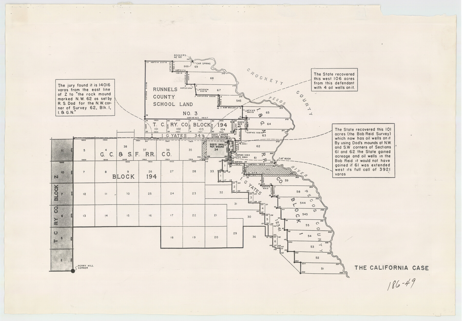
The California Case
186-49
-
Map/Doc
91697
-
Collection
Twichell Survey Records
-
Counties
Pecos
-
Height x Width
17.9 x 12.6 inches
45.5 x 32.0 cm
Part of: Twichell Survey Records
[Sketch of Randall County]
![91756, [Sketch of Randall County], Twichell Survey Records](https://historictexasmaps.com/wmedia_w700/maps/91756-1.tif.jpg)
Print $20.00
- Digital $50.00
[Sketch of Randall County]
Size 21.3 x 18.2 inches
Map/Doc 91756
Subdivision of Sutton County School League 175. Bailey County, Texas

Print $2.00
- Digital $50.00
Subdivision of Sutton County School League 175. Bailey County, Texas
1929
Size 9.1 x 11.5 inches
Map/Doc 90278
Udell -V- Hughes Sketch

Print $20.00
- Digital $50.00
Udell -V- Hughes Sketch
Size 28.8 x 19.4 inches
Map/Doc 90481
[Sketch focusing on surveys just north of Blocks 31 and 32, Township 6N]
![92996, [Sketch focusing on surveys just north of Blocks 31 and 32, Township 6N], Twichell Survey Records](https://historictexasmaps.com/wmedia_w700/maps/92996-1.tif.jpg)
Print $20.00
- Digital $50.00
[Sketch focusing on surveys just north of Blocks 31 and 32, Township 6N]
Size 24.0 x 12.0 inches
Map/Doc 92996
Revised Sectional Map Number 2, Showing Land Surveys in Counties of Howard, Martin, Andrews, Glasscock, Midland, Ector, and Portions of Borden, Dawson, Irion, Reagan, Upton, Crane, Ward, and Winkler, Texas

Print $20.00
- Digital $50.00
Revised Sectional Map Number 2, Showing Land Surveys in Counties of Howard, Martin, Andrews, Glasscock, Midland, Ector, and Portions of Borden, Dawson, Irion, Reagan, Upton, Crane, Ward, and Winkler, Texas
Size 20.0 x 25.4 inches
Map/Doc 91358
Burma, Thailand, Indochina and Malayan Federation

Print $3.00
- Digital $50.00
Burma, Thailand, Indochina and Malayan Federation
Size 10.7 x 14.6 inches
Map/Doc 92376
Section L Tech Memorial Park, Inc.

Print $20.00
- Digital $50.00
Section L Tech Memorial Park, Inc.
1950
Size 17.7 x 19.5 inches
Map/Doc 92350
[Southwest part of County]
![90922, [Southwest part of County], Twichell Survey Records](https://historictexasmaps.com/wmedia_w700/maps/90922-1.tif.jpg)
Print $20.00
- Digital $50.00
[Southwest part of County]
Size 28.8 x 18.4 inches
Map/Doc 90922
[Capitol Leagues 217-228, 238, and vicinity]
![90672, [Capitol Leagues 217-228, 238, and vicinity], Twichell Survey Records](https://historictexasmaps.com/wmedia_w700/maps/90672-1.tif.jpg)
Print $20.00
- Digital $50.00
[Capitol Leagues 217-228, 238, and vicinity]
Size 23.0 x 9.9 inches
Map/Doc 90672
Rio Vista Annex, An Addition to the City of Lubbock

Print $20.00
- Digital $50.00
Rio Vista Annex, An Addition to the City of Lubbock
1947
Size 19.4 x 12.6 inches
Map/Doc 92754
[I. & G. N. RR. Co. Blk. 1]
![89805, [I. & G. N. RR. Co. Blk. 1], Twichell Survey Records](https://historictexasmaps.com/wmedia_w700/maps/89805-1.tif.jpg)
Print $40.00
- Digital $50.00
[I. & G. N. RR. Co. Blk. 1]
Size 36.7 x 49.0 inches
Map/Doc 89805
[Jas. T. Williams Survey and vicinity]
![91263, [Jas. T. Williams Survey and vicinity], Twichell Survey Records](https://historictexasmaps.com/wmedia_w700/maps/91263-1.tif.jpg)
Print $20.00
- Digital $50.00
[Jas. T. Williams Survey and vicinity]
Size 27.0 x 22.1 inches
Map/Doc 91263
You may also like
Brooks County Boundary File 1b

Print $20.00
- Digital $50.00
Brooks County Boundary File 1b
Size 42.2 x 6.6 inches
Map/Doc 50837
Plano del Presidio de Bahia dela Espiritu Santo dependite dela Governacion de los Tejas situado en 29 grad. Y 39 min. de latitud boreal y 277° y 54' dela long. contados desde el Merid. De Tenerife

Plano del Presidio de Bahia dela Espiritu Santo dependite dela Governacion de los Tejas situado en 29 grad. Y 39 min. de latitud boreal y 277° y 54' dela long. contados desde el Merid. De Tenerife
1768
Size 16.7 x 21.0 inches
Map/Doc 96565
Fort Bend County Working Sketch 12

Print $40.00
- Digital $50.00
Fort Bend County Working Sketch 12
1940
Size 29.9 x 73.2 inches
Map/Doc 69219
Tarrant County State Real Property Sketch 1

Print $60.00
- Digital $50.00
Tarrant County State Real Property Sketch 1
2007
Size 24.5 x 35.3 inches
Map/Doc 88666
[Sections 1 & 2, Block S]
![92859, [Sections 1 & 2, Block S], Twichell Survey Records](https://historictexasmaps.com/wmedia_w700/maps/92859-1.tif.jpg)
Print $20.00
- Digital $50.00
[Sections 1 & 2, Block S]
Size 27.8 x 15.7 inches
Map/Doc 92859
Oldham County

Print $40.00
- Digital $50.00
Oldham County
1925
Size 43.6 x 53.5 inches
Map/Doc 66960
Map of Scurry County

Print $20.00
- Digital $50.00
Map of Scurry County
Size 17.8 x 22.7 inches
Map/Doc 92921
Refugio County Boundary File 6a

Print $20.00
- Digital $50.00
Refugio County Boundary File 6a
Size 14.4 x 9.0 inches
Map/Doc 58262
Nueces County Rolled Sketch 39

Print $20.00
- Digital $50.00
Nueces County Rolled Sketch 39
1957
Size 32.9 x 45.3 inches
Map/Doc 6879
Nuevo Mapa Geographico de la America Septentrional, Perteneciente al Virreynato de Mexico

Print $20.00
- Digital $50.00
Nuevo Mapa Geographico de la America Septentrional, Perteneciente al Virreynato de Mexico
1768
Size 23.1 x 30.3 inches
Map/Doc 93835
Kendall County Working Sketch 25

Print $40.00
- Digital $50.00
Kendall County Working Sketch 25
1978
Size 39.4 x 56.8 inches
Map/Doc 66697
Upton County Rolled Sketch JSP

Print $40.00
- Digital $50.00
Upton County Rolled Sketch JSP
1937
Size 39.2 x 68.0 inches
Map/Doc 10042