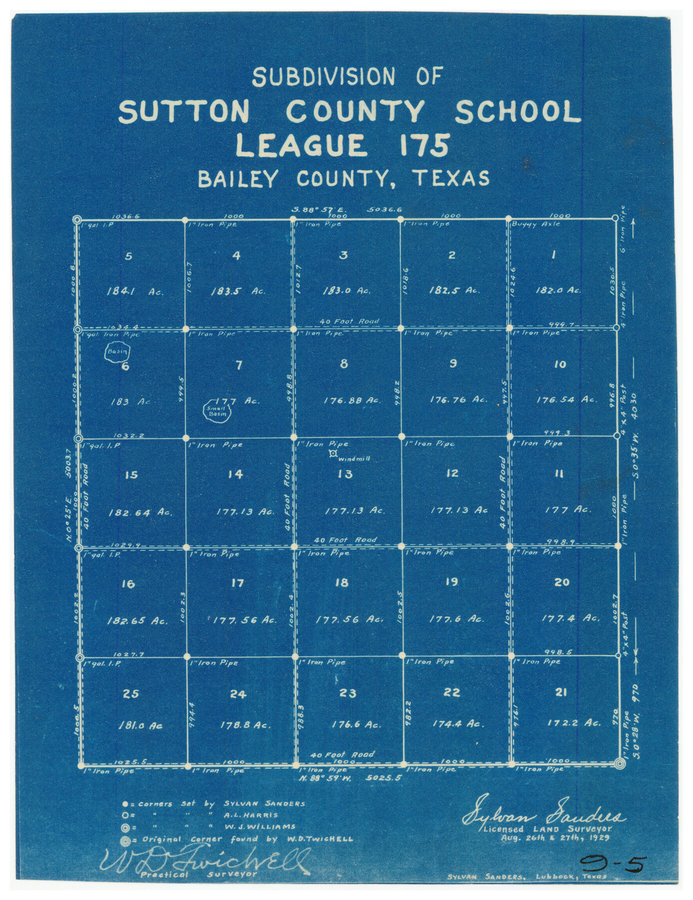
Subdivision of Sutton County School League 175. Bailey County, Texas
9-5
-
Map/Doc
90278
-
Collection
Twichell Survey Records
-
Object Dates
8/27/1929 (Creation Date)
-
People and Organizations
Sylvan Sanders (Surveyor/Engineer)
W.D. Twichell (Surveyor/Engineer)
-
Counties
Bailey
-
Height x Width
9.1 x 11.5 inches
23.1 x 29.2 cm
Part of: Twichell Survey Records
W. L. Ellwood's O Ranch, Lubbock and Hockley Co.

Print $20.00
- Digital $50.00
W. L. Ellwood's O Ranch, Lubbock and Hockley Co.
Size 15.5 x 23.8 inches
Map/Doc 92762
[T. & P. Blocks 33 and 34, Townships 4N and 5N]
![90625, [T. & P. Blocks 33 and 34, Townships 4N and 5N], Twichell Survey Records](https://historictexasmaps.com/wmedia_w700/maps/90625-1.tif.jpg)
Print $20.00
- Digital $50.00
[T. & P. Blocks 33 and 34, Townships 4N and 5N]
Size 14.4 x 17.7 inches
Map/Doc 90625
Lyons Subdivision

Print $20.00
- Digital $50.00
Lyons Subdivision
1946
Size 17.5 x 16.3 inches
Map/Doc 92429
[Blocks GM, D2, D3, GP, and T]
![91503, [Blocks GM, D2, D3, GP, and T], Twichell Survey Records](https://historictexasmaps.com/wmedia_w700/maps/91503-1.tif.jpg)
Print $20.00
- Digital $50.00
[Blocks GM, D2, D3, GP, and T]
Size 32.8 x 15.9 inches
Map/Doc 91503
Section P Tech Memorial Park, Inc.

Print $20.00
- Digital $50.00
Section P Tech Memorial Park, Inc.
1953
Size 21.1 x 32.3 inches
Map/Doc 92353
[Hall, Luce, Aimaguie, and surrounding surveys]
![91191, [Hall, Luce, Aimaguie, and surrounding surveys], Twichell Survey Records](https://historictexasmaps.com/wmedia_w700/maps/91191-1.tif.jpg)
Print $20.00
- Digital $50.00
[Hall, Luce, Aimaguie, and surrounding surveys]
Size 21.0 x 29.1 inches
Map/Doc 91191
[Plat of West Part of Section 144, Block B5]
![90602, [Plat of West Part of Section 144, Block B5], Twichell Survey Records](https://historictexasmaps.com/wmedia_w700/maps/90602-1.tif.jpg)
Print $2.00
- Digital $50.00
[Plat of West Part of Section 144, Block B5]
1931
Size 8.7 x 14.3 inches
Map/Doc 90602
General Highway Map of Garza County, Texas

Print $20.00
- Digital $50.00
General Highway Map of Garza County, Texas
1950
Size 25.9 x 18.8 inches
Map/Doc 92646
Dallam County

Print $20.00
- Digital $50.00
Dallam County
1888
Size 29.4 x 23.9 inches
Map/Doc 90641
Bailey County, Texas

Print $20.00
- Digital $50.00
Bailey County, Texas
Size 30.1 x 41.8 inches
Map/Doc 92528
[J. Sherwood and surrounding surveys]
![90977, [J. Sherwood and surrounding surveys], Twichell Survey Records](https://historictexasmaps.com/wmedia_w700/maps/90977-1.tif.jpg)
Print $20.00
- Digital $50.00
[J. Sherwood and surrounding surveys]
Size 24.2 x 18.1 inches
Map/Doc 90977
[H. & O. B. Blocks 1, B9, 24, J]
![90345, [H. & O. B. Blocks 1, B9, 24, J], Twichell Survey Records](https://historictexasmaps.com/wmedia_w700/maps/90345-1.tif.jpg)
Print $20.00
- Digital $50.00
[H. & O. B. Blocks 1, B9, 24, J]
Size 25.2 x 23.6 inches
Map/Doc 90345
You may also like
University Land Field Notes for Block 13 in Crockett County, Block 11 in Reagan County, Block 12 in Crockett and Reagan Counties, Block 14 in Crockett and Upton Counties, and Block 15 in Upton County

University Land Field Notes for Block 13 in Crockett County, Block 11 in Reagan County, Block 12 in Crockett and Reagan Counties, Block 14 in Crockett and Upton Counties, and Block 15 in Upton County
Map/Doc 81717
Plains Addition to Seagraves, Gaines County, Texas

Print $20.00
- Digital $50.00
Plains Addition to Seagraves, Gaines County, Texas
1948
Size 30.0 x 33.0 inches
Map/Doc 92691
Llano County Sketch File 15

Print $2.00
- Digital $50.00
Llano County Sketch File 15
Size 10.4 x 7.7 inches
Map/Doc 30391
Dimmit County Working Sketch 15

Print $20.00
- Digital $50.00
Dimmit County Working Sketch 15
1942
Size 19.0 x 34.5 inches
Map/Doc 68676
Liberty County Rolled Sketch R

Print $40.00
- Digital $50.00
Liberty County Rolled Sketch R
Size 51.7 x 36.5 inches
Map/Doc 10656
Flight Mission No. DQN-6K, Frame 71, Calhoun County

Print $20.00
- Digital $50.00
Flight Mission No. DQN-6K, Frame 71, Calhoun County
1953
Size 18.5 x 22.2 inches
Map/Doc 84443
Williamson County Working Sketch 9

Print $20.00
- Digital $50.00
Williamson County Working Sketch 9
1954
Size 31.2 x 30.0 inches
Map/Doc 72569
Ward County Working Sketch 38

Print $40.00
- Digital $50.00
Ward County Working Sketch 38
1969
Size 62.2 x 30.3 inches
Map/Doc 72344
Guadalupe County

Print $20.00
- Digital $50.00
Guadalupe County
1977
Size 35.0 x 45.9 inches
Map/Doc 77297
Gillespie County Boundary File 4

Print $56.00
- Digital $50.00
Gillespie County Boundary File 4
Size 13.6 x 9.0 inches
Map/Doc 53754
Victoria County Sketch File 1

Print $20.00
- Digital $50.00
Victoria County Sketch File 1
1853
Size 12.9 x 17.3 inches
Map/Doc 12595
Interfaith's Official Map: The Woodlands, a real hometown for people and companies

Interfaith's Official Map: The Woodlands, a real hometown for people and companies
1997
Size 22.4 x 36.5 inches
Map/Doc 94286