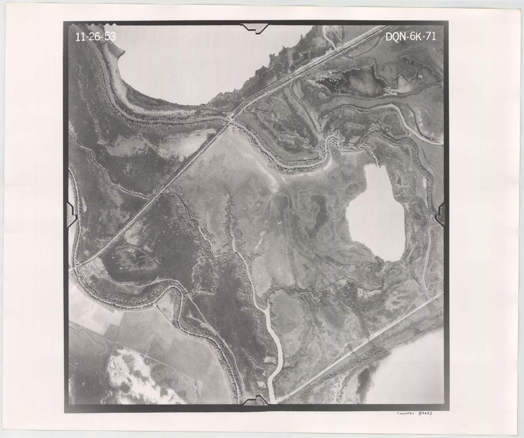
Flight Mission No. DQN-6K, Frame 71, Calhoun County
DQN-6K-71
-
Map/Doc
84443
-
Collection
General Map Collection
-
Object Dates
1953/11/26 (Creation Date)
-
People and Organizations
U. S. Department of Agriculture (Publisher)
-
Counties
Calhoun
-
Subjects
Aerial Photograph
-
Height x Width
18.5 x 22.2 inches
47.0 x 56.4 cm
-
Comments
Flown by Aero Exploration Company of Tulsa, Oklahoma.
Part of: General Map Collection
Texas Coordinate File 5

Print $4.00
- Digital $50.00
Texas Coordinate File 5
Size 11.2 x 8.7 inches
Map/Doc 75312
[Capitol Lands in Dallam, Hartley, Oldham, Deaf Smith, Parmer, Bailey, Lamb, Cochran, Castro, and Hockley Counties]
![60295, [Capitol Lands in Dallam, Hartley, Oldham, Deaf Smith, Parmer, Bailey, Lamb, Cochran, Castro, and Hockley Counties], General Map Collection](https://historictexasmaps.com/wmedia_w700/maps/60295.tif.jpg)
Print $40.00
- Digital $50.00
[Capitol Lands in Dallam, Hartley, Oldham, Deaf Smith, Parmer, Bailey, Lamb, Cochran, Castro, and Hockley Counties]
Size 55.4 x 22.0 inches
Map/Doc 60295
McMullen County Sketch File 44

Print $6.00
- Digital $50.00
McMullen County Sketch File 44
1942
Size 14.2 x 8.8 inches
Map/Doc 31426
[Peter's Colony surveys in Stephens County]
![75986, [Peter's Colony surveys in Stephens County], General Map Collection](https://historictexasmaps.com/wmedia_w700/maps/75986.tif.jpg)
Print $20.00
- Digital $50.00
[Peter's Colony surveys in Stephens County]
Size 25.3 x 21.1 inches
Map/Doc 75986
Right of Way and Track Map, Galveston, Harrisburg & San Antonio Ry. operated by the T. & N. O. R.R. Co., Victoria Division, Rosenberg to Beeville

Print $40.00
- Digital $50.00
Right of Way and Track Map, Galveston, Harrisburg & San Antonio Ry. operated by the T. & N. O. R.R. Co., Victoria Division, Rosenberg to Beeville
Size 24.3 x 55.8 inches
Map/Doc 76162
Hood County Sketch File 8

Print $4.00
- Digital $50.00
Hood County Sketch File 8
Size 7.8 x 8.0 inches
Map/Doc 26584
Cochran County Boundary File 7

Print $6.00
- Digital $50.00
Cochran County Boundary File 7
Size 14.0 x 9.1 inches
Map/Doc 51567
Texas-United States Boundary Line 1

Print $4.00
- Digital $50.00
Texas-United States Boundary Line 1
1843
Size 12.6 x 7.8 inches
Map/Doc 74974
Fisher County

Print $40.00
- Digital $50.00
Fisher County
1944
Size 48.4 x 42.5 inches
Map/Doc 73147
San Patricio County Sketch File 23

Print $20.00
San Patricio County Sketch File 23
1910
Size 22.9 x 12.9 inches
Map/Doc 12286
Flight Mission No. CGI-3N, Frame 120, Cameron County

Print $20.00
- Digital $50.00
Flight Mission No. CGI-3N, Frame 120, Cameron County
1954
Size 18.8 x 22.3 inches
Map/Doc 84593
Dickens County Sketch File 15

Print $4.00
- Digital $50.00
Dickens County Sketch File 15
Size 12.6 x 8.0 inches
Map/Doc 20973
You may also like
Haskell County Working Sketch 6

Print $20.00
- Digital $50.00
Haskell County Working Sketch 6
1949
Size 18.9 x 16.4 inches
Map/Doc 66064
Pecos County Working Sketch 91b
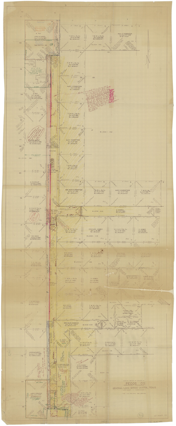
Print $40.00
- Digital $50.00
Pecos County Working Sketch 91b
1965
Size 78.9 x 32.7 inches
Map/Doc 71564
General Highway Map, Delta County, Hopkins County, Texas

Print $20.00
General Highway Map, Delta County, Hopkins County, Texas
1940
Size 25.2 x 18.5 inches
Map/Doc 79073
Upton County Rolled Sketch 39

Print $40.00
- Digital $50.00
Upton County Rolled Sketch 39
Size 53.4 x 44.1 inches
Map/Doc 10055
Medina County Rolled Sketch 5

Print $40.00
- Digital $50.00
Medina County Rolled Sketch 5
1948
Size 52.0 x 47.1 inches
Map/Doc 9505
Flight Mission No. DAG-24K, Frame 128, Matagorda County

Print $20.00
- Digital $50.00
Flight Mission No. DAG-24K, Frame 128, Matagorda County
1953
Size 17.2 x 22.5 inches
Map/Doc 86546
Kimble County Working Sketch 38

Print $20.00
- Digital $50.00
Kimble County Working Sketch 38
1946
Size 37.4 x 26.2 inches
Map/Doc 70106
Flight Mission No. DCL-7C, Frame 137, Kenedy County

Print $20.00
- Digital $50.00
Flight Mission No. DCL-7C, Frame 137, Kenedy County
1943
Size 15.4 x 15.3 inches
Map/Doc 86094
Nolan County Sketch File A

Print $20.00
- Digital $50.00
Nolan County Sketch File A
Size 22.4 x 19.9 inches
Map/Doc 42170
Brewster County Working Sketch 110

Print $40.00
- Digital $50.00
Brewster County Working Sketch 110
1982
Size 48.9 x 40.1 inches
Map/Doc 67710
From Citizens of Shelby and Red River Counties Living East of the Sabine River and Southwest of the Sulphur Fork of Red River for the Creation of a New County to be Called Green, March 11, 1837/April 1, 1837

Print $20.00
From Citizens of Shelby and Red River Counties Living East of the Sabine River and Southwest of the Sulphur Fork of Red River for the Creation of a New County to be Called Green, March 11, 1837/April 1, 1837
2020
Size 24.3 x 21.7 inches
Map/Doc 96373
[Plat of Colorado River Survey, McCulloch County]
![2462, [Plat of Colorado River Survey, McCulloch County], General Map Collection](https://historictexasmaps.com/wmedia_w700/maps/2462-1.tif.jpg)
Print $40.00
- Digital $50.00
[Plat of Colorado River Survey, McCulloch County]
1918
Size 40.3 x 159.2 inches
Map/Doc 2462