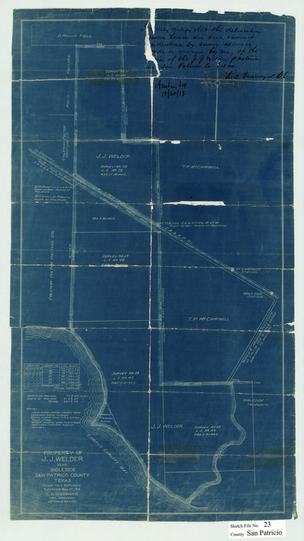
San Patricio County Sketch File 23
Property of J.J. Welder near Ingleside, San Patricio County, Texas
-
Map/Doc
12286
-
Collection
General Map Collection
-
Object Dates
11/22/1910 (Creation Date)
-
People and Organizations
L.A. Gueringer (Surveyor/Engineer)
-
Counties
San Patricio
-
Subjects
Surveying Sketch File
-
Height x Width
22.9 x 12.9 inches
58.2 x 32.8 cm
-
Medium
blueprint/diazo
-
Scale
1" = 500 varas
-
Features
SA&AP
Public Road to Gregory
McCampbell Station
Avenue B
Aransas Pass
Ingleside Station
Corpus Christi Bay
Kinney Bayou
Part of: General Map Collection
[Gulf Colorado & Santa Fe from 2178+36.0 to 3901+06.2]
![64695, [Gulf Colorado & Santa Fe from 2178+36.0 to 3901+06.2], General Map Collection](https://historictexasmaps.com/wmedia_w700/maps/64695-1.tif.jpg)
Print $40.00
- Digital $50.00
[Gulf Colorado & Santa Fe from 2178+36.0 to 3901+06.2]
Size 33.6 x 120.7 inches
Map/Doc 64695
Hutchinson County Sketch File 15

Print $20.00
- Digital $50.00
Hutchinson County Sketch File 15
Size 20.7 x 26.7 inches
Map/Doc 11813
Irion County Rolled Sketch 3

Print $20.00
- Digital $50.00
Irion County Rolled Sketch 3
Size 26.2 x 27.5 inches
Map/Doc 6318
Flight Mission No. CGI-3N, Frame 106, Cameron County

Print $20.00
- Digital $50.00
Flight Mission No. CGI-3N, Frame 106, Cameron County
1954
Size 18.5 x 22.2 inches
Map/Doc 84586
Presidio County Working Sketch 109

Print $20.00
- Digital $50.00
Presidio County Working Sketch 109
1980
Size 23.3 x 21.4 inches
Map/Doc 71786
Falls County Sketch File 1

Print $4.00
- Digital $50.00
Falls County Sketch File 1
1852
Size 10.7 x 8.6 inches
Map/Doc 22330
Flight Mission No. CZW-1R, Frame 165, Hardeman County

Print $20.00
- Digital $50.00
Flight Mission No. CZW-1R, Frame 165, Hardeman County
1956
Size 18.7 x 22.4 inches
Map/Doc 85236
Pecos County Boundary File 69

Print $22.00
- Digital $50.00
Pecos County Boundary File 69
Size 7.8 x 3.4 inches
Map/Doc 57890
Motley County Boundary File 2e

Print $40.00
- Digital $50.00
Motley County Boundary File 2e
Size 29.4 x 96.1 inches
Map/Doc 57561
Galveston County Sketch File 10

Print $4.00
- Digital $50.00
Galveston County Sketch File 10
1869
Size 12.8 x 8.0 inches
Map/Doc 23372
Flight Mission No. DAG-23K, Frame 187, Matagorda County

Print $20.00
- Digital $50.00
Flight Mission No. DAG-23K, Frame 187, Matagorda County
1953
Size 17.5 x 22.4 inches
Map/Doc 86522
Angelina County Working Sketch 47

Print $20.00
- Digital $50.00
Angelina County Working Sketch 47
1976
Size 36.9 x 41.9 inches
Map/Doc 67130
You may also like
Lubbock County Sketch File 9

Print $4.00
- Digital $50.00
Lubbock County Sketch File 9
1907
Size 5.7 x 8.7 inches
Map/Doc 30430
Crockett County Working Sketch 96

Print $20.00
- Digital $50.00
Crockett County Working Sketch 96
1979
Size 25.5 x 16.9 inches
Map/Doc 68429
Heydrick's Ownership Map of Concho Co. Tex.

Print $20.00
- Digital $50.00
Heydrick's Ownership Map of Concho Co. Tex.
1919
Size 33.9 x 37.9 inches
Map/Doc 92616
Roberts County Sketch File 4

Print $12.00
- Digital $50.00
Roberts County Sketch File 4
1889
Size 8.7 x 7.8 inches
Map/Doc 35306
Flight Mission No. BRA-7M, Frame 186, Jefferson County

Print $20.00
- Digital $50.00
Flight Mission No. BRA-7M, Frame 186, Jefferson County
1953
Size 18.4 x 22.2 inches
Map/Doc 85554
Kendall County Boundary File 54

Print $16.00
- Digital $50.00
Kendall County Boundary File 54
Size 8.6 x 3.5 inches
Map/Doc 55769
Concho County Rolled Sketch 8

Print $20.00
- Digital $50.00
Concho County Rolled Sketch 8
1956
Size 24.0 x 15.9 inches
Map/Doc 5546
Matagorda County Sketch File 41

Print $6.00
- Digital $50.00
Matagorda County Sketch File 41
Size 10.2 x 12.1 inches
Map/Doc 30832

Wharton County Working Sketch 4

Print $20.00
- Digital $50.00
Wharton County Working Sketch 4
Size 16.3 x 21.3 inches
Map/Doc 72468
Foard County Sketch File 15

Print $8.00
- Digital $50.00
Foard County Sketch File 15
1883
Size 13.0 x 8.5 inches
Map/Doc 22821
Waller County Sketch File 3

Print $4.00
- Digital $50.00
Waller County Sketch File 3
Size 13.0 x 8.4 inches
Map/Doc 39598