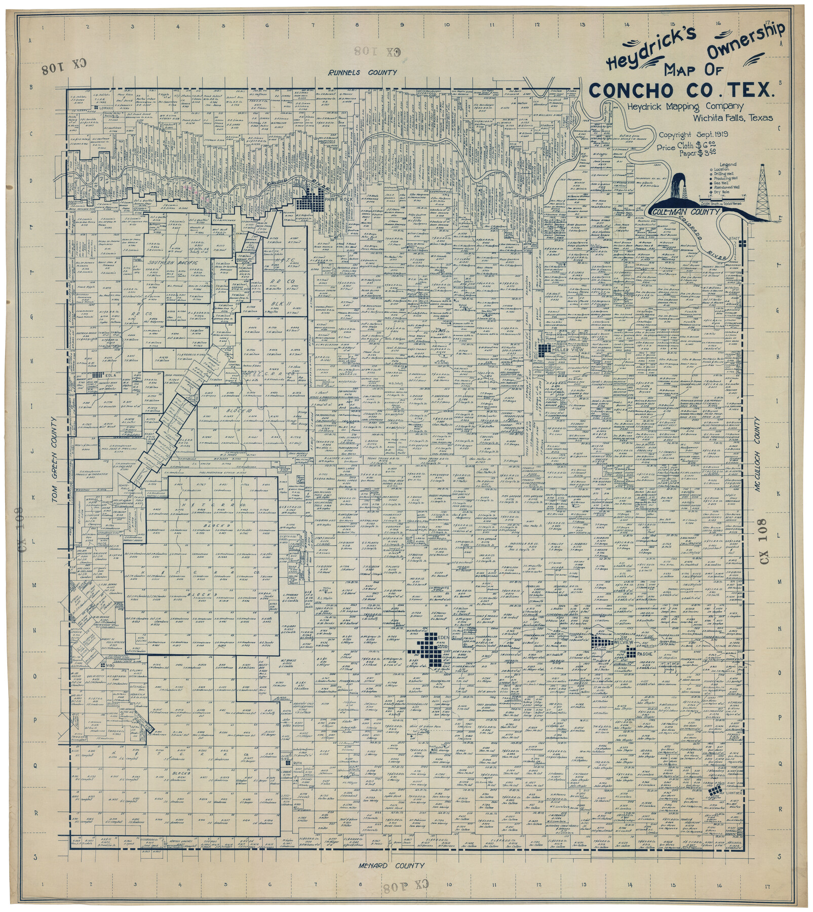
Heydrick's Ownership Map of Concho Co. Tex.
CX108
- 
                          Map/Doc92616
- 
                            CollectionTwichell Survey Records
- 
                            Object Dates1919 (Creation Date)
- 
                            CountiesCastro
- 
                            SubjectsCounty
- 
                            Height x Width33.9 x 37.9 inches86.1 x 96.3 cm
Part of: Twichell Survey Records
            Gaines County Sketch


                                            Print $20.00                    
                                             -                         Digital $50.00                                    
                Gaines County Sketch
Size 9.7 x 18.5 inches
                                Map/Doc 92668
            
            W. D. McMillan Estate


                                            Print $20.00                    
                                             -                         Digital $50.00                                    
                W. D. McMillan Estate
1951
Size 18.0 x 23.1 inches
                                Map/Doc 92730
            
            [Randall County]
            
                                    ![92970, [Randall County], Twichell Survey Records](https://historictexasmaps.com/wmedia_w700/maps/92970-1.tif.jpg) 


    ![92970, [Randall County], Twichell Survey Records](https://historictexasmaps.com/wmedia_w700/maps/92970-1.tif.jpg) 
                                
            
                                            Print $20.00                    
                                             -                         Digital $50.00                                    
                [Randall County]
Size 14.7 x 12.0 inches
                                Map/Doc 92970
            
            Carter Estate, North Half 77, Block A, Lubbock County


                                            Print $20.00                    
                                             -                         Digital $50.00                                    
                Carter Estate, North Half 77, Block A, Lubbock County
1941
Size 9.8 x 18.4 inches
                                Map/Doc 92751
            
            Working Sketch Cochran and Yoakum Co's.


                                            Print $40.00                    
                                             -                         Digital $50.00                                    
                Working Sketch Cochran and Yoakum Co's.
1919
Size 54.2 x 14.5 inches
                                Map/Doc 89678
            
            [Area north of Leagues 1 & 4, Morris County School Land]
            
                                    ![90353, [Area north of Leagues 1 & 4, Morris County School Land], Twichell Survey Records](https://historictexasmaps.com/wmedia_w700/maps/90353-1.tif.jpg) 


    ![90353, [Area north of Leagues 1 & 4, Morris County School Land], Twichell Survey Records](https://historictexasmaps.com/wmedia_w700/maps/90353-1.tif.jpg) 
                                
            
                                            Print $20.00                    
                                             -                         Digital $50.00                                    
                [Area north of Leagues 1 & 4, Morris County School Land]
Size 21.3 x 16.0 inches
                                Map/Doc 90353
            
            [Plat showing well locations]
            
                                    ![91667, [Plat showing well locations], Twichell Survey Records](https://historictexasmaps.com/wmedia_w700/maps/91667-1.tif.jpg) 


    ![91667, [Plat showing well locations], Twichell Survey Records](https://historictexasmaps.com/wmedia_w700/maps/91667-1.tif.jpg) 
                                
            
                                            Print $3.00                    
                                             -                         Digital $50.00                                    
                [Plat showing well locations]
Size 13.3 x 11.3 inches
                                Map/Doc 91667
            
            [Southeast Yoakum County, Southwest Terry County and North Gaines County]
            
                                    ![91876, [Southeast Yoakum County, Southwest Terry County and North Gaines County], Twichell Survey Records](https://historictexasmaps.com/wmedia_w700/maps/91876-1.tif.jpg) 


    ![91876, [Southeast Yoakum County, Southwest Terry County and North Gaines County], Twichell Survey Records](https://historictexasmaps.com/wmedia_w700/maps/91876-1.tif.jpg) 
                                
            
                                            Print $20.00                    
                                             -                         Digital $50.00                                    
                [Southeast Yoakum County, Southwest Terry County and North Gaines County]
Size 20.7 x 16.6 inches
                                Map/Doc 91876
            
            Water Distribution Seagraves Located in Surveys 10 & 15, Block C-34


                                            Print $20.00                    
                                             -                         Digital $50.00                                    
                Water Distribution Seagraves Located in Surveys 10 & 15, Block C-34
Size 22.1 x 15.8 inches
                                Map/Doc 92899
            
            Revised  Sectional Map Number 2, Showing Lands in Howard, Martin, Andrews, Glasscock, Midland, Ector, and Portions of Borden, Dawson, Irion, Reagan, Upton, Crane, Ward, and Winkler Counties


                                            Print $20.00                    
                                             -                         Digital $50.00                                    
                Revised Sectional Map Number 2, Showing Lands in Howard, Martin, Andrews, Glasscock, Midland, Ector, and Portions of Borden, Dawson, Irion, Reagan, Upton, Crane, Ward, and Winkler Counties
1908
Size 16.6 x 13.3 inches
                                Map/Doc 91113
            You may also like
            Map of Van Zandt County


                                            Print $20.00                    
                                             -                         Digital $50.00                                    
                Map of Van Zandt County
1853
Size 19.4 x 20.6 inches
                                Map/Doc 16957
            
            Bowie County Sketch File 8b


                                            Print $6.00                    
                                             -                         Digital $50.00                                    
                Bowie County Sketch File 8b
1927
Size 6.2 x 9.9 inches
                                Map/Doc 14875
            
            Cameron Empresario Colony. September 28, 1828


                                            Print $20.00                    
                                    
                Cameron Empresario Colony. September 28, 1828
2020
Size 10.4 x 21.7 inches
                                Map/Doc 95987
            
            Flight Mission No. DCL-7C, Frame 123, Kenedy County


                                            Print $20.00                    
                                             -                         Digital $50.00                                    
                Flight Mission No. DCL-7C, Frame 123, Kenedy County
1943
Size 18.5 x 22.2 inches
                                Map/Doc 86088
            
            Travis County Rolled Sketch 58


                                            Print $20.00                    
                                             -                         Digital $50.00                                    
                Travis County Rolled Sketch 58
Size 37.4 x 25.5 inches
                                Map/Doc 8049
            
            Flight Mission No. DQO-11K, Frame 27, Galveston County


                                            Print $20.00                    
                                             -                         Digital $50.00                                    
                Flight Mission No. DQO-11K, Frame 27, Galveston County
1952
Size 18.8 x 22.4 inches
                                Map/Doc 85224
            
            Terrell County Working Sketch 38


                                            Print $40.00                    
                                             -                         Digital $50.00                                    
                Terrell County Working Sketch 38
1950
Size 89.1 x 24.9 inches
                                Map/Doc 62131
            
            Topographical Map of the Rio Grande, Sheet No. 30


                                            Print $20.00                    
                                             -                         Digital $50.00                                    
                Topographical Map of the Rio Grande, Sheet No. 30
1912
Map/Doc 89554
            
            Panola County Sketch File 17


                                            Print $20.00                    
                                             -                         Digital $50.00                                    
                Panola County Sketch File 17
Size 15.2 x 17.7 inches
                                Map/Doc 12137
            
            [Map of Chicago, Rock Island & Texas Railway through Tarrant County, Texas]
            
                                    ![64412, [Map of Chicago, Rock Island & Texas Railway through Tarrant County, Texas], General Map Collection](https://historictexasmaps.com/wmedia_w700/maps/64412.tif.jpg) 


    ![64412, [Map of Chicago, Rock Island & Texas Railway through Tarrant County, Texas], General Map Collection](https://historictexasmaps.com/wmedia_w700/maps/64412.tif.jpg) 
                                
            
                                            Print $40.00                    
                                             -                         Digital $50.00                                    
                [Map of Chicago, Rock Island & Texas Railway through Tarrant County, Texas]
1893
Size 22.9 x 122.0 inches
                                Map/Doc 64412
            
            Brownfield Plant Arizona Chemical Co.


                                            Print $20.00                    
                                             -                         Digital $50.00                                    
                Brownfield Plant Arizona Chemical Co.
Size 27.0 x 44.4 inches
                                Map/Doc 92417
            
            Matagorda County NRC Article 33.136 Location Key Sheet


                                            Print $20.00                    
                                             -                         Digital $50.00                                    
                Matagorda County NRC Article 33.136 Location Key Sheet
1973
Size 27.0 x 23.0 inches
                                Map/Doc 88832
             
                        ![92161, [Block K], Twichell Survey Records](https://historictexasmaps.com/wmedia_w700/maps/92161-1.tif.jpg) 
                                