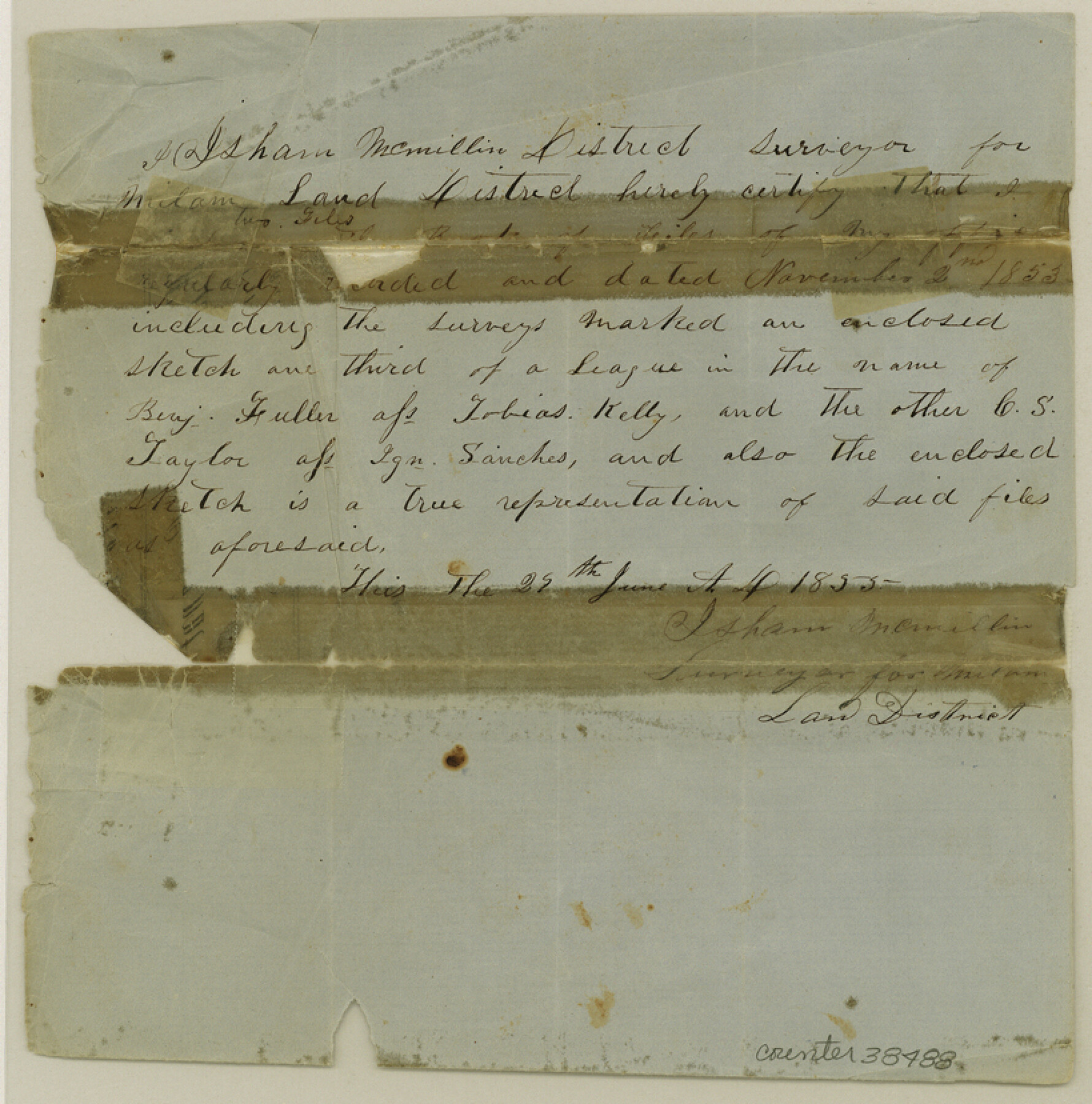
Trinity County Sketch File 1
[Surveyor's certificate accompanying map filed]
-
Map/Doc
38488
-
Collection
General Map Collection
-
Object Dates
6/29/1855 (Creation Date)
7/11/1855 (File Date)
-
People and Organizations
Isham McMillin (Surveyor/Engineer)
-
Counties
Trinity
-
Subjects
Surveying Sketch File
-
Height x Width
8.3 x 8.2 inches
21.1 x 20.8 cm
-
Medium
paper, manuscript
Part of: General Map Collection
[Sketch for Mineral Application 33721 - 33725 Incl. - Padre and Mustang Island]
![2877, [Sketch for Mineral Application 33721 - 33725 Incl. - Padre and Mustang Island], General Map Collection](https://historictexasmaps.com/wmedia_w700/maps/2877.tif.jpg)
Print $20.00
- Digital $50.00
[Sketch for Mineral Application 33721 - 33725 Incl. - Padre and Mustang Island]
1942
Size 29.8 x 22.6 inches
Map/Doc 2877
Cameron County Rolled Sketch 25

Print $20.00
- Digital $50.00
Cameron County Rolled Sketch 25
1977
Size 24.9 x 36.7 inches
Map/Doc 5799
Concho County

Print $20.00
- Digital $50.00
Concho County
1947
Size 46.8 x 36.9 inches
Map/Doc 73115
Bastrop County Sketch File 9A

Print $40.00
- Digital $50.00
Bastrop County Sketch File 9A
Map/Doc 88484
Brazoria County Rolled Sketch 20

Print $20.00
- Digital $50.00
Brazoria County Rolled Sketch 20
1917
Size 31.1 x 47.1 inches
Map/Doc 8929
San Jacinto County Working Sketch 43

Print $20.00
- Digital $50.00
San Jacinto County Working Sketch 43
1981
Size 36.4 x 45.5 inches
Map/Doc 63757
Flight Mission No. BRA-7M, Frame 193, Jefferson County

Print $20.00
- Digital $50.00
Flight Mission No. BRA-7M, Frame 193, Jefferson County
1953
Size 18.7 x 22.4 inches
Map/Doc 85561
Red River County Working Sketch 38

Print $20.00
- Digital $50.00
Red River County Working Sketch 38
1965
Size 24.0 x 24.9 inches
Map/Doc 72021
Map of Hamilton County

Print $20.00
- Digital $50.00
Map of Hamilton County
1872
Size 15.0 x 21.9 inches
Map/Doc 4557
Presidio County Sketch File 121

Print $57.00
- Digital $50.00
Presidio County Sketch File 121
1998
Size 11.0 x 8.5 inches
Map/Doc 82620
Kinney County Rolled Sketch 11

Print $20.00
- Digital $50.00
Kinney County Rolled Sketch 11
1944
Size 39.2 x 32.0 inches
Map/Doc 6540
Hutchinson County Rolled Sketch 44-19

Print $20.00
- Digital $50.00
Hutchinson County Rolled Sketch 44-19
2002
Size 24.0 x 36.0 inches
Map/Doc 77555
You may also like
Refugio County Working Sketch 8

Print $40.00
- Digital $50.00
Refugio County Working Sketch 8
1940
Size 56.7 x 42.9 inches
Map/Doc 63517
Cogdell Ranch Kent County, Texas

Print $20.00
- Digital $50.00
Cogdell Ranch Kent County, Texas
1950
Size 36.3 x 19.2 inches
Map/Doc 92188
El Paso County Working Sketch 30

Print $40.00
- Digital $50.00
El Paso County Working Sketch 30
1967
Size 32.0 x 65.8 inches
Map/Doc 69052
Burnet County Sketch File 40

Print $4.00
- Digital $50.00
Burnet County Sketch File 40
Size 14.2 x 8.6 inches
Map/Doc 16755
Rio Grande Rectification Project, El Paso and Juarez Valley

Print $20.00
- Digital $50.00
Rio Grande Rectification Project, El Paso and Juarez Valley
1935
Size 10.7 x 29.6 inches
Map/Doc 60859
Bexar County Sketch File 52

Print $28.00
- Digital $50.00
Bexar County Sketch File 52
1935
Size 13.5 x 16.8 inches
Map/Doc 14534
Wharton County Rolled Sketch 13

Print $20.00
- Digital $50.00
Wharton County Rolled Sketch 13
1990
Size 22.4 x 28.1 inches
Map/Doc 8238
Potter County Sketch File 23

Print $4.00
- Digital $50.00
Potter County Sketch File 23
Size 11.1 x 8.7 inches
Map/Doc 34421
Flight Mission No. CRC-4R, Frame 103, Chambers County

Print $20.00
- Digital $50.00
Flight Mission No. CRC-4R, Frame 103, Chambers County
1956
Size 18.4 x 22.3 inches
Map/Doc 84900
Kimble County Sketch File 3

Print $4.00
- Digital $50.00
Kimble County Sketch File 3
1847
Size 9.1 x 11.5 inches
Map/Doc 28910
Presidio County Working Sketch 134

Print $40.00
- Digital $50.00
Presidio County Working Sketch 134
1989
Size 37.0 x 55.6 inches
Map/Doc 71812
Map of Aransas Co.

Print $20.00
- Digital $50.00
Map of Aransas Co.
1896
Size 38.8 x 36.8 inches
Map/Doc 4874