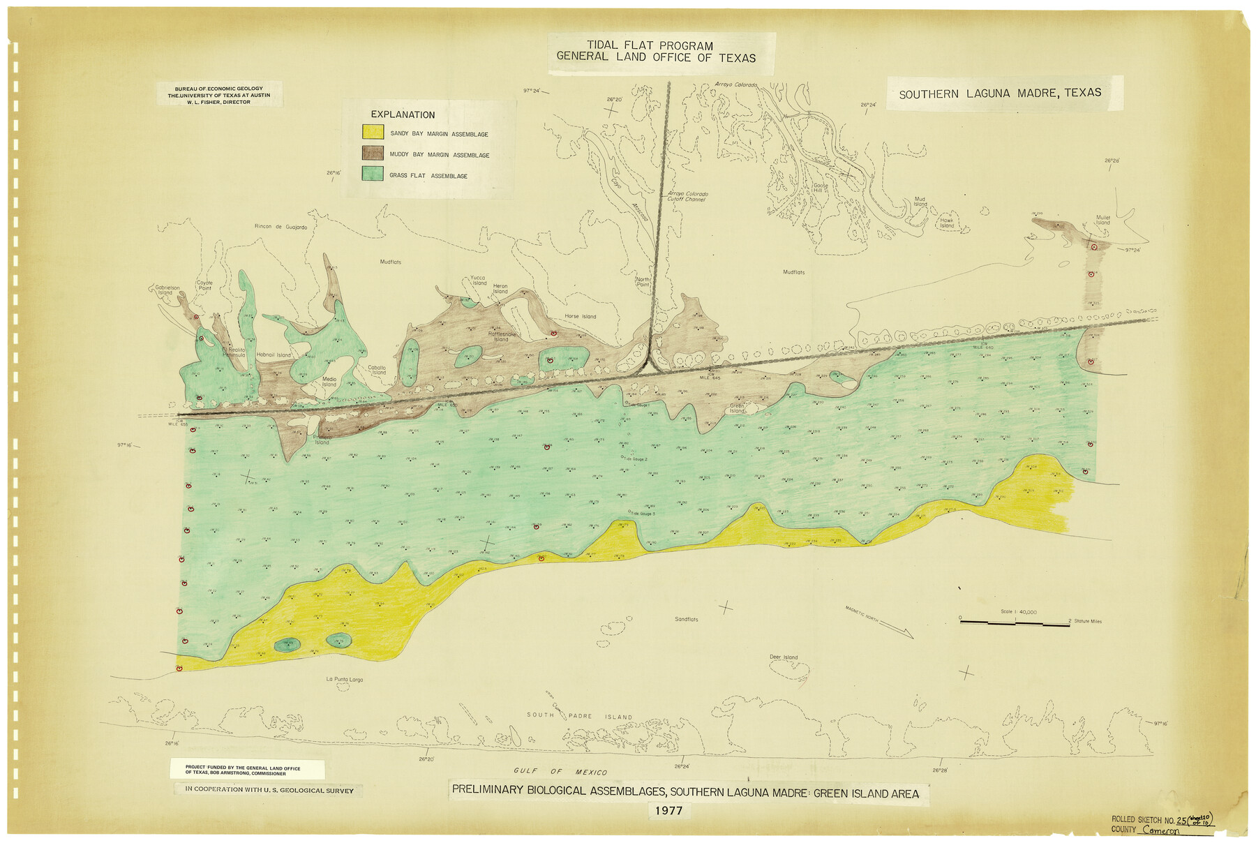
Cameron County Rolled Sketch 25
Preliminary Biological Assemblages, Southern Laguna Madre: Green Island Area [Page 10 of 10]
-
Map/Doc
5799
-
Collection
General Map Collection
-
Object Dates
1977 (Creation Date)
12/6/1983 (File Date)
-
People and Organizations
Bureau of Economic Geology, University of Texas (Publisher)
W.L. Fisher (Author)
-
Counties
Cameron
-
Subjects
Surveying Rolled Sketch
-
Height x Width
24.9 x 36.7 inches
63.3 x 93.2 cm
-
Medium
paper, etching/engraving/lithograph
Related maps
Cameron County Rolled Sketch 25

Print $20.00
- Digital $50.00
Cameron County Rolled Sketch 25
1977
Size 17.5 x 27.5 inches
Map/Doc 5790
Cameron County Rolled Sketch 25

Print $40.00
- Digital $50.00
Cameron County Rolled Sketch 25
1977
Size 25.0 x 72.9 inches
Map/Doc 5791
Cameron County Rolled Sketch 25

Print $20.00
- Digital $50.00
Cameron County Rolled Sketch 25
1977
Size 24.8 x 36.8 inches
Map/Doc 5792
Cameron County Rolled Sketch 25

Print $20.00
- Digital $50.00
Cameron County Rolled Sketch 25
1977
Size 24.5 x 30.4 inches
Map/Doc 5793
Cameron County Rolled Sketch 25

Print $20.00
- Digital $50.00
Cameron County Rolled Sketch 25
1977
Size 24.9 x 36.7 inches
Map/Doc 5794
Cameron County Rolled Sketch 25

Print $20.00
- Digital $50.00
Cameron County Rolled Sketch 25
1977
Size 24.7 x 36.7 inches
Map/Doc 5795
Cameron County Rolled Sketch 25

Print $20.00
- Digital $50.00
Cameron County Rolled Sketch 25
1977
Size 24.6 x 36.7 inches
Map/Doc 5796
Cameron County Rolled Sketch 25

Print $20.00
- Digital $50.00
Cameron County Rolled Sketch 25
1977
Size 24.8 x 36.5 inches
Map/Doc 5797
Cameron County Rolled Sketch 25

Print $20.00
- Digital $50.00
Cameron County Rolled Sketch 25
1977
Size 24.8 x 36.6 inches
Map/Doc 5798
Part of: General Map Collection
Flight Mission No. BRE-1P, Frame 49, Nueces County

Print $20.00
- Digital $50.00
Flight Mission No. BRE-1P, Frame 49, Nueces County
1956
Size 18.4 x 22.2 inches
Map/Doc 86638
Marion County Working Sketch 45

Print $20.00
- Digital $50.00
Marion County Working Sketch 45
2005
Size 27.0 x 29.2 inches
Map/Doc 83576
Harris County Working Sketch 78

Print $20.00
- Digital $50.00
Harris County Working Sketch 78
1968
Size 32.8 x 25.8 inches
Map/Doc 65970
McClennan County Robertson District East of the Brazos Milam District West of the Brazos

Print $20.00
- Digital $50.00
McClennan County Robertson District East of the Brazos Milam District West of the Brazos
1877
Size 21.9 x 24.5 inches
Map/Doc 3864
Reagan County Rolled Sketch 10

Print $20.00
- Digital $50.00
Reagan County Rolled Sketch 10
1939
Size 18.7 x 15.8 inches
Map/Doc 7438
Marshall Ford Dam right of way survey, General Ownership Map

Print $40.00
- Digital $50.00
Marshall Ford Dam right of way survey, General Ownership Map
1942
Size 36.6 x 55.9 inches
Map/Doc 60402
Martin County Working Sketch 5

Print $20.00
- Digital $50.00
Martin County Working Sketch 5
1971
Size 42.9 x 31.0 inches
Map/Doc 70823
Pecos County Working Sketch 9

Print $20.00
- Digital $50.00
Pecos County Working Sketch 9
1907
Size 32.4 x 26.7 inches
Map/Doc 71479
Flight Mission No. BRA-3M, Frame 192, Jefferson County

Print $20.00
- Digital $50.00
Flight Mission No. BRA-3M, Frame 192, Jefferson County
1953
Size 18.5 x 22.4 inches
Map/Doc 85407
Glasscock County Rolled Sketch 1

Print $20.00
- Digital $50.00
Glasscock County Rolled Sketch 1
1906
Size 37.3 x 33.6 inches
Map/Doc 9055
Nueces County Rolled Sketch 104B

Print $20.00
- Digital $50.00
Nueces County Rolled Sketch 104B
1975
Size 24.2 x 29.0 inches
Map/Doc 61778
Jack County Rolled Sketch 3A

Print $20.00
- Digital $50.00
Jack County Rolled Sketch 3A
1985
Size 34.9 x 32.2 inches
Map/Doc 6334
You may also like
San Augustine County Sketch File 20

Print $82.00
- Digital $50.00
San Augustine County Sketch File 20
1951
Size 8.9 x 14.4 inches
Map/Doc 35680
Angelina County Working Sketch 31

Print $20.00
- Digital $50.00
Angelina County Working Sketch 31
1955
Size 24.3 x 24.5 inches
Map/Doc 67113
Duval County Sketch File 61

Print $6.00
- Digital $50.00
Duval County Sketch File 61
1940
Size 11.4 x 8.9 inches
Map/Doc 21431
Flight Mission No. DQN-5K, Frame 30, Calhoun County

Print $20.00
- Digital $50.00
Flight Mission No. DQN-5K, Frame 30, Calhoun County
1953
Size 16.7 x 16.5 inches
Map/Doc 84381
Jefferson County Rolled Sketch 25A

Print $20.00
- Digital $50.00
Jefferson County Rolled Sketch 25A
Size 24.4 x 39.6 inches
Map/Doc 6389
Parker County Sketch File 34

Print $20.00
- Digital $50.00
Parker County Sketch File 34
1878
Size 21.3 x 13.6 inches
Map/Doc 12148
Montgomery County Rolled Sketch 18

Print $40.00
- Digital $50.00
Montgomery County Rolled Sketch 18
Size 51.4 x 25.3 inches
Map/Doc 9528
[Surveys in Austin's Colony along the San Bernardo River, West Bernardo River, and Lone Tree Creek]
![194, [Surveys in Austin's Colony along the San Bernardo River, West Bernardo River, and Lone Tree Creek], General Map Collection](https://historictexasmaps.com/wmedia_w700/maps/194-1.tif.jpg)
Print $20.00
- Digital $50.00
[Surveys in Austin's Colony along the San Bernardo River, West Bernardo River, and Lone Tree Creek]
1830
Size 28.3 x 17.8 inches
Map/Doc 194
Edwards County Working Sketch 39

Print $20.00
- Digital $50.00
Edwards County Working Sketch 39
1948
Size 28.7 x 32.3 inches
Map/Doc 68915

Outer Continental Shelf Leasing Maps (Louisiana Offshore Operations)

Print $20.00
- Digital $50.00
Outer Continental Shelf Leasing Maps (Louisiana Offshore Operations)
1959
Size 18.3 x 14.5 inches
Map/Doc 76112
Map of Texas and Pacific Ry. Company's Surveys in the 80 Mile Reserve

Print $40.00
- Digital $50.00
Map of Texas and Pacific Ry. Company's Surveys in the 80 Mile Reserve
1885
Map/Doc 2241