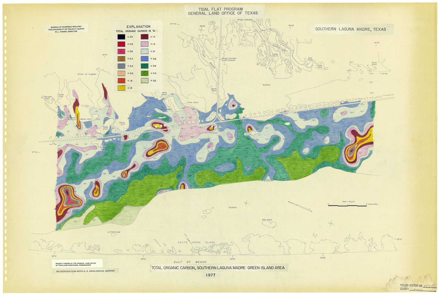
Cameron County Rolled Sketch 25
Total Organic Carbon, Southern Laguna Madre: Green Island Area [Page 8 of 10]
-
Map/Doc
5797
-
Collection
General Map Collection
-
Object Dates
1977 (Creation Date)
12/6/1983 (File Date)
-
People and Organizations
Bureau of Economic Geology, University of Texas (Publisher)
W.L. Fisher (Author)
-
Counties
Cameron
-
Subjects
Surveying Rolled Sketch
-
Height x Width
24.8 x 36.5 inches
63.0 x 92.7 cm
-
Medium
paper, etching/engraving/lithograph
-
Comments
See maps 5790-5799 for all sheets in this set.
Related maps
Cameron County Rolled Sketch 25

Print $20.00
- Digital $50.00
Cameron County Rolled Sketch 25
1977
Size 17.5 x 27.5 inches
Map/Doc 5790
Cameron County Rolled Sketch 25

Print $40.00
- Digital $50.00
Cameron County Rolled Sketch 25
1977
Size 25.0 x 72.9 inches
Map/Doc 5791
Cameron County Rolled Sketch 25

Print $20.00
- Digital $50.00
Cameron County Rolled Sketch 25
1977
Size 24.8 x 36.8 inches
Map/Doc 5792
Cameron County Rolled Sketch 25

Print $20.00
- Digital $50.00
Cameron County Rolled Sketch 25
1977
Size 24.5 x 30.4 inches
Map/Doc 5793
Cameron County Rolled Sketch 25

Print $20.00
- Digital $50.00
Cameron County Rolled Sketch 25
1977
Size 24.9 x 36.7 inches
Map/Doc 5794
Cameron County Rolled Sketch 25

Print $20.00
- Digital $50.00
Cameron County Rolled Sketch 25
1977
Size 24.7 x 36.7 inches
Map/Doc 5795
Cameron County Rolled Sketch 25

Print $20.00
- Digital $50.00
Cameron County Rolled Sketch 25
1977
Size 24.6 x 36.7 inches
Map/Doc 5796
Cameron County Rolled Sketch 25

Print $20.00
- Digital $50.00
Cameron County Rolled Sketch 25
1977
Size 24.8 x 36.6 inches
Map/Doc 5798
Cameron County Rolled Sketch 25

Print $20.00
- Digital $50.00
Cameron County Rolled Sketch 25
1977
Size 24.9 x 36.7 inches
Map/Doc 5799
Part of: General Map Collection
Lamar County Texas

Print $20.00
- Digital $50.00
Lamar County Texas
1879
Size 23.4 x 18.3 inches
Map/Doc 3784
Map of Anderson County

Print $20.00
- Digital $50.00
Map of Anderson County
1879
Size 18.9 x 23.5 inches
Map/Doc 3229
Atascosa County Working Sketch 11

Print $20.00
- Digital $50.00
Atascosa County Working Sketch 11
1923
Size 13.9 x 17.1 inches
Map/Doc 67207
Official Map of the Highway System of Texas

Print $20.00
- Digital $50.00
Official Map of the Highway System of Texas
1936
Size 27.5 x 33.4 inches
Map/Doc 83599
Coast Chart No. 210 - Aransas Pass and Corpus Christi Bay with the coast to latitude 27° 12', Texas

Print $20.00
- Digital $50.00
Coast Chart No. 210 - Aransas Pass and Corpus Christi Bay with the coast to latitude 27° 12', Texas
1887
Size 30.4 x 24.0 inches
Map/Doc 73444

Panola County Sketch File 29

Print $7.00
- Digital $50.00
Panola County Sketch File 29
1842
Size 10.0 x 8.1 inches
Map/Doc 33502
Refugio County Sketch File 25

Print $6.00
- Digital $50.00
Refugio County Sketch File 25
1915
Size 14.5 x 6.4 inches
Map/Doc 35289
Kaufman County Sketch File 3

Print $20.00
- Digital $50.00
Kaufman County Sketch File 3
1857
Size 25.3 x 18.7 inches
Map/Doc 4856
Ector County Sketch File 5

Print $6.00
- Digital $50.00
Ector County Sketch File 5
1939
Size 9.1 x 14.5 inches
Map/Doc 21637
Walker County Working Sketch 9

Print $20.00
- Digital $50.00
Walker County Working Sketch 9
1935
Size 23.7 x 27.0 inches
Map/Doc 72289
[Beaumont, Sour Lake and Western Ry. Right of Way and Alignment - Frisco]
![64119, [Beaumont, Sour Lake and Western Ry. Right of Way and Alignment - Frisco], General Map Collection](https://historictexasmaps.com/wmedia_w700/maps/64119.tif.jpg)
Print $20.00
- Digital $50.00
[Beaumont, Sour Lake and Western Ry. Right of Way and Alignment - Frisco]
1910
Size 20.0 x 45.8 inches
Map/Doc 64119
You may also like
Hudspeth County Working Sketch 34

Print $40.00
- Digital $50.00
Hudspeth County Working Sketch 34
1977
Size 63.1 x 37.3 inches
Map/Doc 66319
Padre Island National Seashore

Print $4.00
- Digital $50.00
Padre Island National Seashore
Size 16.1 x 22.1 inches
Map/Doc 60531
Medina County Rolled Sketch 22

Print $20.00
- Digital $50.00
Medina County Rolled Sketch 22
2007
Size 24.5 x 18.4 inches
Map/Doc 88849
Flight Mission No. DQN-1K, Frame 42, Calhoun County

Print $20.00
- Digital $50.00
Flight Mission No. DQN-1K, Frame 42, Calhoun County
1953
Size 18.5 x 18.7 inches
Map/Doc 84142
![88949, Hartley Co[unty], Library of Congress](https://historictexasmaps.com/wmedia_w700/maps/88949.tif.jpg)
Jasper County Working Sketch 32

Print $20.00
- Digital $50.00
Jasper County Working Sketch 32
1993
Size 18.7 x 22.7 inches
Map/Doc 66494
San Patricio County Aerial Photograph Index Sheet 5

Print $20.00
- Digital $50.00
San Patricio County Aerial Photograph Index Sheet 5
1957
Size 23.9 x 19.2 inches
Map/Doc 83747
Map of Texas from the most recent authorities

Print $20.00
- Digital $50.00
Map of Texas from the most recent authorities
1845
Size 14.2 x 18.0 inches
Map/Doc 96628

Angelina County Working Sketch 44

Print $20.00
- Digital $50.00
Angelina County Working Sketch 44
1976
Size 22.2 x 25.7 inches
Map/Doc 67127
Flight Mission No. DQO-1K, Frame 146, Galveston County

Print $20.00
- Digital $50.00
Flight Mission No. DQO-1K, Frame 146, Galveston County
1952
Size 18.9 x 22.5 inches
Map/Doc 84999
Randall County Sketch File 5

Print $20.00
- Digital $50.00
Randall County Sketch File 5
1931
Size 23.9 x 41.7 inches
Map/Doc 10583