Refugio County Sketch File 25
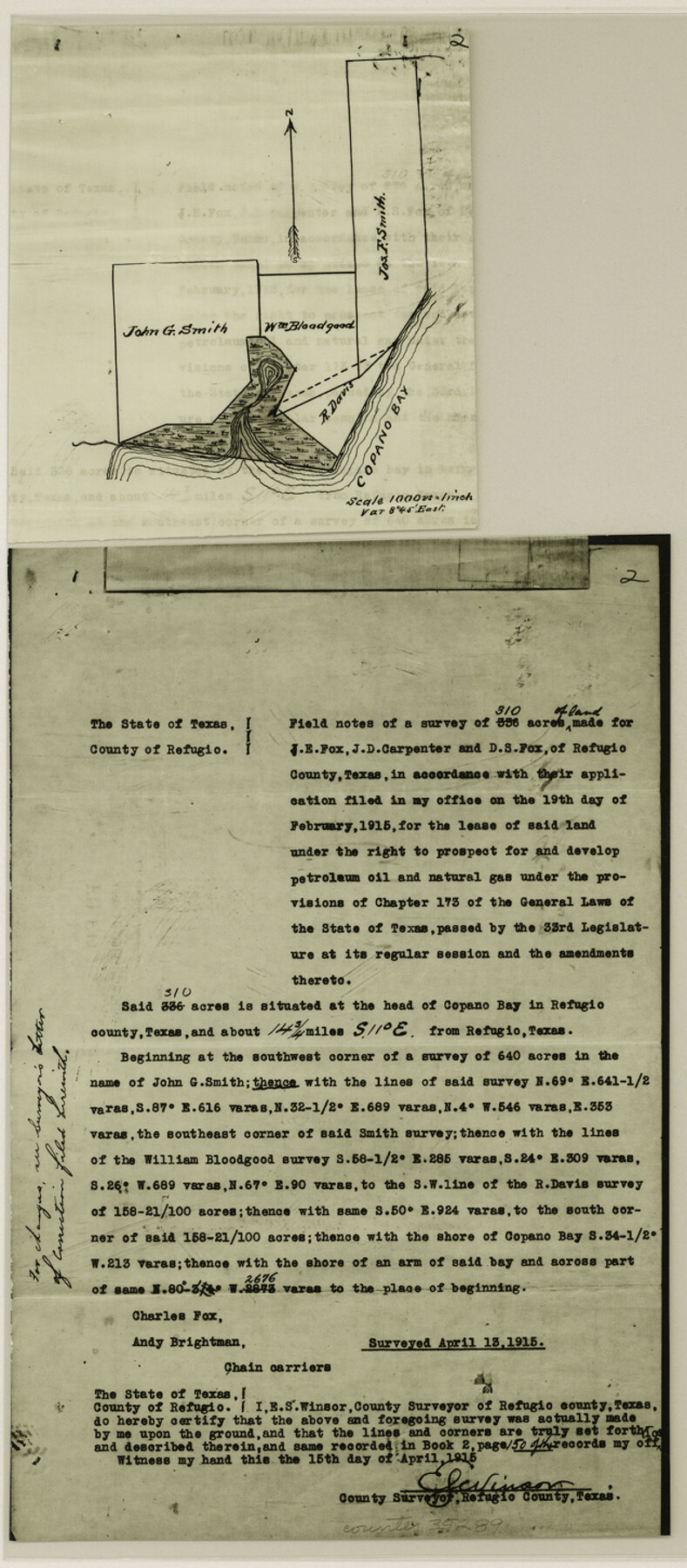
[Copy of sketch and field notes of a survey of 310 acres from Mineral File 1287 in the south corner of the county along Copano Bay]
-
Map/Doc
35289
-
Collection
General Map Collection
-
Object Dates
1915 (Creation Date)
5/19/1915 (File Date)
4/13/1915 (Survey Date)
-
People and Organizations
E.S. Winsor (Surveyor/Engineer)
Charles Fox (Chainman/Field Personnel)
Andy Brightman (Chainman/Field Personnel)
-
Counties
Refugio
-
Subjects
Surveying Sketch File
-
Height x Width
14.5 x 6.4 inches
36.8 x 16.3 cm
-
Medium
photostat
-
Scale
1" = 1000 varas
-
Features
Copano Bay
Refugio
Part of: General Map Collection
Hartley County Sketch File 1

Print $40.00
- Digital $50.00
Hartley County Sketch File 1
Size 9.7 x 18.4 inches
Map/Doc 11696
Houston County Working Sketch 7

Print $20.00
- Digital $50.00
Houston County Working Sketch 7
1935
Size 24.7 x 36.8 inches
Map/Doc 66237
[Surveys along the Medina River]
![52, [Surveys along the Medina River], General Map Collection](https://historictexasmaps.com/wmedia_w700/maps/52.tif.jpg)
Print $2.00
- Digital $50.00
[Surveys along the Medina River]
1840
Size 8.2 x 14.3 inches
Map/Doc 52
Gulf Intracoastal Waterway, Tex. - Aransas Bay to Corpus Christi Bay - Modified Route of Main Channel/Dredging

Print $20.00
- Digital $50.00
Gulf Intracoastal Waterway, Tex. - Aransas Bay to Corpus Christi Bay - Modified Route of Main Channel/Dredging
1958
Size 30.8 x 42.8 inches
Map/Doc 61896
Goliad County Working Sketch 25

Print $20.00
- Digital $50.00
Goliad County Working Sketch 25
1994
Size 19.6 x 21.9 inches
Map/Doc 63215
Photo Index of Texas Coast - Sheet 5 of 6

Print $20.00
- Digital $50.00
Photo Index of Texas Coast - Sheet 5 of 6
1954
Size 20.0 x 24.0 inches
Map/Doc 83443
Tyler County Working Sketch 3

Print $20.00
- Digital $50.00
Tyler County Working Sketch 3
1922
Size 28.0 x 32.6 inches
Map/Doc 69473
Jeff Davis County Working Sketch 27

Print $20.00
- Digital $50.00
Jeff Davis County Working Sketch 27
1960
Size 18.1 x 24.3 inches
Map/Doc 66522
Flight Mission No. CRC-2R, Frame 187, Chambers County

Print $20.00
- Digital $50.00
Flight Mission No. CRC-2R, Frame 187, Chambers County
1956
Size 18.6 x 22.4 inches
Map/Doc 84765

Edwards County Working Sketch 1

Print $20.00
- Digital $50.00
Edwards County Working Sketch 1
Size 12.2 x 16.4 inches
Map/Doc 68877
[Surveys in the Liberty District]
![162, [Surveys in the Liberty District], General Map Collection](https://historictexasmaps.com/wmedia_w700/maps/162.tif.jpg)
Print $2.00
- Digital $50.00
[Surveys in the Liberty District]
1841
Size 7.6 x 10.3 inches
Map/Doc 162
You may also like
Polk County Working Sketch 28

Print $40.00
- Digital $50.00
Polk County Working Sketch 28
1960
Size 53.5 x 43.6 inches
Map/Doc 71644
Dimmit County Working Sketch 37

Print $20.00
- Digital $50.00
Dimmit County Working Sketch 37
1962
Size 28.9 x 25.6 inches
Map/Doc 68698
Terrell County Sketch File 24

Print $20.00
- Digital $50.00
Terrell County Sketch File 24
1932
Size 22.0 x 41.8 inches
Map/Doc 10387
Lubbock County Rolled Sketch 5

Print $20.00
- Digital $50.00
Lubbock County Rolled Sketch 5
Size 19.8 x 14.2 inches
Map/Doc 6641
Dawson County Sketch File 19

Print $20.00
- Digital $50.00
Dawson County Sketch File 19
1951
Size 18.5 x 24.7 inches
Map/Doc 11295
Grayson County Sketch File 21

Print $14.00
- Digital $50.00
Grayson County Sketch File 21
Size 7.7 x 17.8 inches
Map/Doc 24495
La Salle County Sketch File 9

Print $4.00
- Digital $50.00
La Salle County Sketch File 9
Size 6.3 x 8.3 inches
Map/Doc 29458
[Jesse Folk and Surrounding Surveys]
![91086, [Jesse Folk and Surrounding Surveys], Twichell Survey Records](https://historictexasmaps.com/wmedia_w700/maps/91086-1.tif.jpg)
Print $20.00
- Digital $50.00
[Jesse Folk and Surrounding Surveys]
Size 14.9 x 18.3 inches
Map/Doc 91086
Val Verde County Working Sketch 47

Print $20.00
- Digital $50.00
Val Verde County Working Sketch 47
1946
Size 41.4 x 42.6 inches
Map/Doc 72182
Williamson County Working Sketch 8

Print $20.00
- Digital $50.00
Williamson County Working Sketch 8
1950
Size 43.4 x 25.4 inches
Map/Doc 72568
Right of Way and Track Map of The Missouri, Kansas & Texas Railway of Texas

Print $40.00
- Digital $50.00
Right of Way and Track Map of The Missouri, Kansas & Texas Railway of Texas
1918
Size 25.0 x 50.7 inches
Map/Doc 64536
Newton County Working Sketch 2

Print $20.00
- Digital $50.00
Newton County Working Sketch 2
1905
Size 14.5 x 19.3 inches
Map/Doc 71248