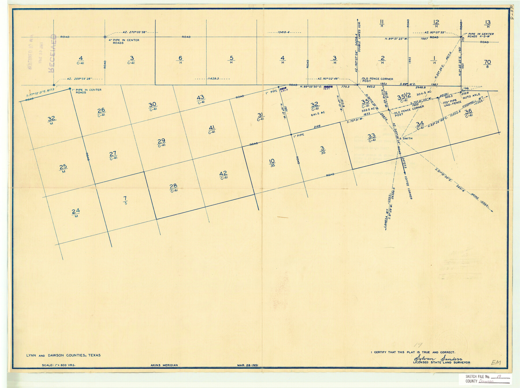
Dawson County Sketch File 19
Sketch of surveys in Block C-41 and Block H in North Central Part of Dawson County
-
Map/Doc
11295
-
Collection
General Map Collection
-
Object Dates
1951/3/28 (Creation Date)
1951/4/19 (File Date)
-
People and Organizations
Sylvan Sanders (Surveyor/Engineer)
-
Counties
Dawson Lynn
-
Subjects
Surveying Sketch File
-
Height x Width
18.5 x 24.7 inches
47.0 x 62.7 cm
-
Medium
blueprint/diazo
-
Scale
1:800
Part of: General Map Collection
Austin County Rolled Sketch 7

Print $47.00
- Digital $50.00
Austin County Rolled Sketch 7
1974
Size 10.4 x 15.3 inches
Map/Doc 42340
Dawson County Sketch File D

Print $20.00
- Digital $50.00
Dawson County Sketch File D
1917
Size 30.0 x 40.3 inches
Map/Doc 10363
Map of Jones County

Print $20.00
- Digital $50.00
Map of Jones County
1898
Size 41.9 x 39.8 inches
Map/Doc 4996
Pecos County Rolled Sketch 129

Print $40.00
- Digital $50.00
Pecos County Rolled Sketch 129
1948
Size 42.9 x 52.4 inches
Map/Doc 9727
Erath County Working Sketch 5

Print $20.00
- Digital $50.00
Erath County Working Sketch 5
1920
Size 27.6 x 17.1 inches
Map/Doc 69086

Map of the State of Texas from the most recent authorities

Print $20.00
- Digital $50.00
Map of the State of Texas from the most recent authorities
1850
Size 13.8 x 17.3 inches
Map/Doc 89251
La Salle County Working Sketch 5

Print $20.00
- Digital $50.00
La Salle County Working Sketch 5
1915
Size 17.2 x 13.4 inches
Map/Doc 70306
[Surveys in the Bexar District along the Medina River]
![130, [Surveys in the Bexar District along the Medina River], General Map Collection](https://historictexasmaps.com/wmedia_w700/maps/130.tif.jpg)
Print $20.00
- Digital $50.00
[Surveys in the Bexar District along the Medina River]
1841
Size 20.7 x 12.8 inches
Map/Doc 130
Kenedy County Rolled Sketch 3

Print $40.00
- Digital $50.00
Kenedy County Rolled Sketch 3
1904
Size 40.1 x 57.4 inches
Map/Doc 9329
Texas 1849: A Lone Star Rising

Print $20.00
- Digital $50.00
Texas 1849: A Lone Star Rising
2000
Size 40.6 x 40.7 inches
Map/Doc 78270
Harris County Working Sketch 94

Print $20.00
- Digital $50.00
Harris County Working Sketch 94
1978
Size 20.9 x 40.2 inches
Map/Doc 65986
You may also like
[Surveys in the Montgomery District: San Jacinto River and Caney Creek, Navidad, Navasota]
![69744, [Surveys in the Montgomery District: San Jacinto River and Caney Creek, Navidad, Navasota], General Map Collection](https://historictexasmaps.com/wmedia_w700/maps/69744.tif.jpg)
Print $2.00
- Digital $50.00
[Surveys in the Montgomery District: San Jacinto River and Caney Creek, Navidad, Navasota]
Size 5.1 x 7.3 inches
Map/Doc 69744
Reeves County

Print $40.00
- Digital $50.00
Reeves County
1945
Size 48.3 x 39.8 inches
Map/Doc 73273
Map of Chambers County

Print $20.00
- Digital $50.00
Map of Chambers County
1874
Size 20.4 x 24.4 inches
Map/Doc 3380
Supreme Court of the United States, October Term, 1924, No. 13, Original - The State of Oklahoma, Complainant vs. The State of Texas, Defendant, The United States, Intervener

Print $20.00
- Digital $50.00
Supreme Court of the United States, October Term, 1924, No. 13, Original - The State of Oklahoma, Complainant vs. The State of Texas, Defendant, The United States, Intervener
1924
Size 19.5 x 32.6 inches
Map/Doc 75112
Castro County

Print $20.00
- Digital $50.00
Castro County
1884
Size 12.6 x 16.1 inches
Map/Doc 90396
[Texas & Pacific Railway, Longview to Dallas]
![64097, [Texas & Pacific Railway, Longview to Dallas], General Map Collection](https://historictexasmaps.com/wmedia_w700/maps/64097.tif.jpg)
Print $40.00
- Digital $50.00
[Texas & Pacific Railway, Longview to Dallas]
1873
Size 15.5 x 124.0 inches
Map/Doc 64097
Maps of Gulf Intracoastal Waterway, Texas - Sabine River to the Rio Grande and connecting waterways including ship channels

Print $20.00
- Digital $50.00
Maps of Gulf Intracoastal Waterway, Texas - Sabine River to the Rio Grande and connecting waterways including ship channels
1966
Size 14.6 x 20.5 inches
Map/Doc 62000
Texas 1973 Official Highway Travel Map

Texas 1973 Official Highway Travel Map
Size 28.1 x 36.3 inches
Map/Doc 94406

Map of Jack County

Print $20.00
- Digital $50.00
Map of Jack County
Size 18.4 x 15.9 inches
Map/Doc 3702
Fannin County Working Sketch 8

Print $20.00
- Digital $50.00
Fannin County Working Sketch 8
1955
Size 27.2 x 16.0 inches
Map/Doc 69162
Houston, (Capital de Tejas)

Print $20.00
- Digital $50.00
Houston, (Capital de Tejas)
1845
Size 6.8 x 10.0 inches
Map/Doc 97238