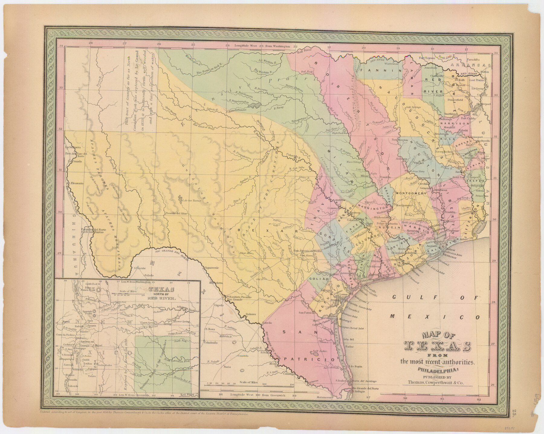
Map of the State of Texas from the most recent authorities
-
Map/Doc
89251
-
Collection
General Map Collection
-
Object Dates
1850 (Creation Date)
2010/1/19 (File Date)
-
People and Organizations
Thomas, Cowperthwait and Co. (Publisher)
-
Subjects
State of Texas
-
Height x Width
13.8 x 17.3 inches
35.1 x 43.9 cm
Part of: General Map Collection
Kinney County Rolled Sketch 3

Print $20.00
- Digital $50.00
Kinney County Rolled Sketch 3
Size 31.4 x 23.2 inches
Map/Doc 6535
Hartley County Boundary File 1a

Print $50.00
- Digital $50.00
Hartley County Boundary File 1a
Size 14.1 x 8.8 inches
Map/Doc 54437
Hardeman County Sketch File 8a

Print $20.00
- Digital $50.00
Hardeman County Sketch File 8a
Size 16.0 x 32.0 inches
Map/Doc 11623

Tom Green County Sketch File 82

Print $20.00
- Digital $50.00
Tom Green County Sketch File 82
1888
Size 18.5 x 20.9 inches
Map/Doc 12454
Flight Mission No. DAG-14K, Frame 140, Matagorda County

Print $20.00
- Digital $50.00
Flight Mission No. DAG-14K, Frame 140, Matagorda County
1952
Size 17.6 x 17.6 inches
Map/Doc 86307
Presidio County Sketch File 97

Print $12.00
- Digital $50.00
Presidio County Sketch File 97
1962
Size 14.4 x 8.7 inches
Map/Doc 34777
Flight Mission No. BQR-20K, Frame 3, Brazoria County

Print $20.00
- Digital $50.00
Flight Mission No. BQR-20K, Frame 3, Brazoria County
1952
Size 18.6 x 22.2 inches
Map/Doc 84105
[Surveys in the Bexar District along the Leona River]
![135, [Surveys in the Bexar District along the Leona River], General Map Collection](https://historictexasmaps.com/wmedia_w700/maps/135.tif.jpg)
Print $20.00
- Digital $50.00
[Surveys in the Bexar District along the Leona River]
1841
Size 19.9 x 10.9 inches
Map/Doc 135
Mitchell County Boundary File 1c

Print $12.00
- Digital $50.00
Mitchell County Boundary File 1c
Size 8.7 x 12.3 inches
Map/Doc 57361
Map of Comal County

Print $40.00
- Digital $50.00
Map of Comal County
1897
Size 44.3 x 48.5 inches
Map/Doc 4681
Nueces County Sketch File 68

Print $8.00
- Digital $50.00
Nueces County Sketch File 68
Size 11.0 x 8.7 inches
Map/Doc 33000
You may also like
Flight Mission No. BQY-4M, Frame 36, Harris County

Print $20.00
- Digital $50.00
Flight Mission No. BQY-4M, Frame 36, Harris County
1953
Size 18.6 x 22.3 inches
Map/Doc 85251
[Surveys in the Harris District at Clear Lake]
![276, [Surveys in the Harris District at Clear Lake], General Map Collection](https://historictexasmaps.com/wmedia_w700/maps/276-1.tif.jpg)
Print $2.00
- Digital $50.00
[Surveys in the Harris District at Clear Lake]
1840
Size 6.7 x 10.5 inches
Map/Doc 276
Hunt County Working Sketch Graphic Index

Print $40.00
- Digital $50.00
Hunt County Working Sketch Graphic Index
1944
Size 50.5 x 37.0 inches
Map/Doc 76585
Presidio County Working Sketch 70

Print $20.00
- Digital $50.00
Presidio County Working Sketch 70
1961
Size 46.8 x 37.4 inches
Map/Doc 71747
Wichita County Rolled Sketch 11

Print $20.00
- Digital $50.00
Wichita County Rolled Sketch 11
Size 20.8 x 18.6 inches
Map/Doc 8248
General Highway Map, Kendall County, Texas

Print $20.00
General Highway Map, Kendall County, Texas
1961
Size 18.3 x 24.6 inches
Map/Doc 79549
Flight Mission No. BRA-7M, Frame 122, Jefferson County

Print $20.00
- Digital $50.00
Flight Mission No. BRA-7M, Frame 122, Jefferson County
1953
Size 18.7 x 22.3 inches
Map/Doc 85516
Flight Mission No. CRK-8P, Frame 122, Refugio County

Print $20.00
- Digital $50.00
Flight Mission No. CRK-8P, Frame 122, Refugio County
1956
Size 18.4 x 22.1 inches
Map/Doc 86977
Burnet County Rolled Sketch T

Print $20.00
- Digital $50.00
Burnet County Rolled Sketch T
Size 24.7 x 18.3 inches
Map/Doc 5359
King County Sketch File 7A

Print $28.00
- Digital $50.00
King County Sketch File 7A
1902
Size 22.1 x 34.7 inches
Map/Doc 11936
Wilbarger County Working Sketch 20

Print $20.00
- Digital $50.00
Wilbarger County Working Sketch 20
1976
Size 27.4 x 43.4 inches
Map/Doc 72558
Shelby County Rolled Sketch 21

Print $20.00
- Digital $50.00
Shelby County Rolled Sketch 21
Size 17.0 x 22.3 inches
Map/Doc 93285