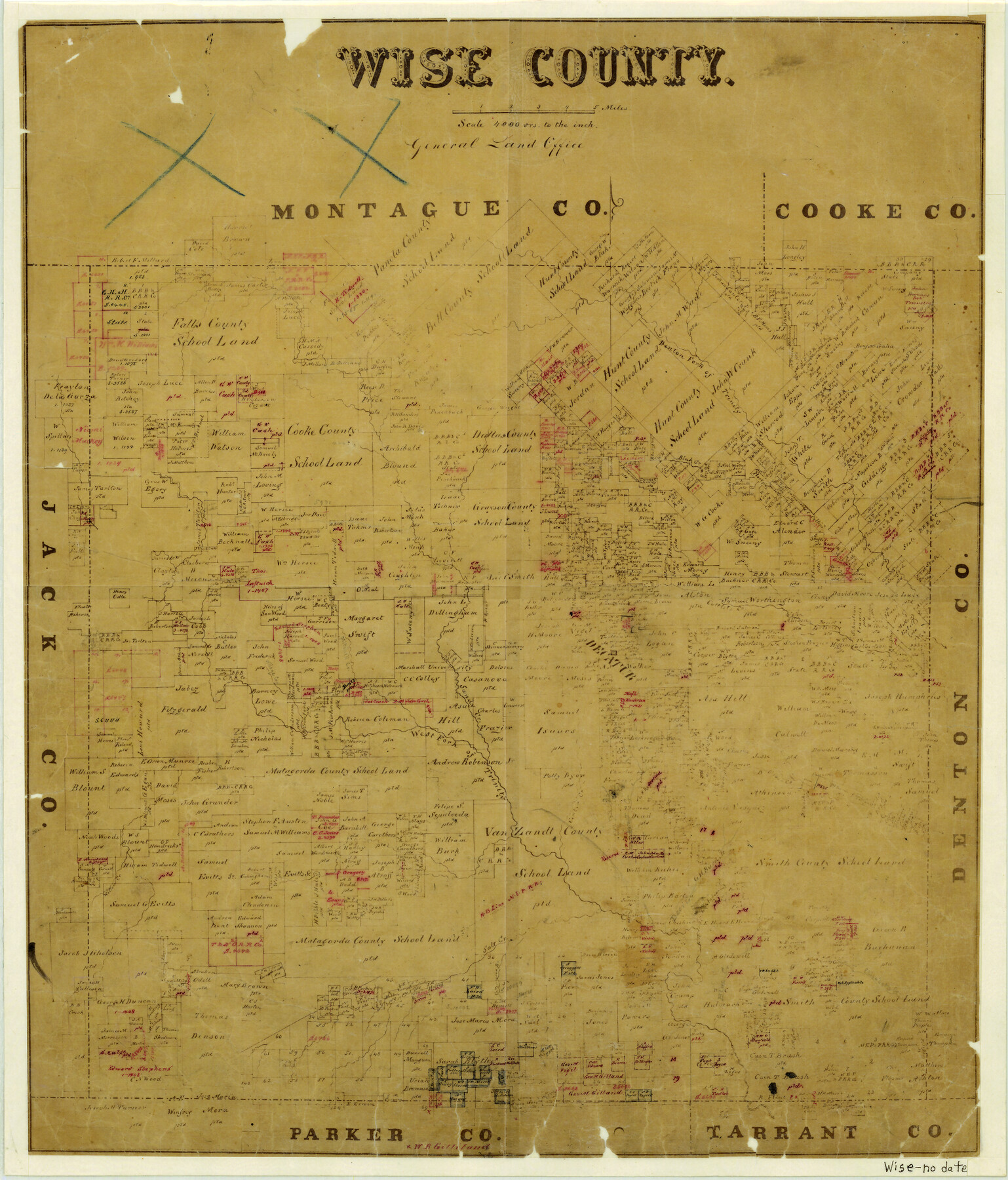
Wise County
-
Map/Doc
4163
-
Collection
General Map Collection
-
People and Organizations
Texas General Land Office (Publisher)
-
Counties
Wise
-
Subjects
County
-
Height x Width
19.7 x 16.8 inches
50.0 x 42.7 cm
-
Features
Denton Fork of Trinity River
Blak [sic] Creek
Village Creek
Mitchell Creek
Decatur
Cattlets Creek
Sandy Creek
West Fork of Trinity River
Center Creek
Walnut Creek
Deer Creek
Salt Creek
Willow Creek
Cottonwood Branch [of Salt Creek]
Elizabeth's Creek
MEP&P
Part of: General Map Collection
Real County Rolled Sketch 1

Print $20.00
- Digital $50.00
Real County Rolled Sketch 1
1941
Size 20.6 x 28.9 inches
Map/Doc 7452
Flight Mission No. DIX-6P, Frame 188, Aransas County

Print $20.00
- Digital $50.00
Flight Mission No. DIX-6P, Frame 188, Aransas County
1956
Size 19.0 x 22.9 inches
Map/Doc 83850
South Montgomery County, Woodlands Chamber of Commerce Street Map

South Montgomery County, Woodlands Chamber of Commerce Street Map
Size 50.0 x 37.8 inches
Map/Doc 94364
J. De Cordova's Map of the State of Texas Compiled from the records of the General Land Office of the State

Print $20.00
- Digital $50.00
J. De Cordova's Map of the State of Texas Compiled from the records of the General Land Office of the State
1849
Size 34.0 x 31.5 inches
Map/Doc 656
Stonewall County Working Sketch 16

Print $20.00
- Digital $50.00
Stonewall County Working Sketch 16
1954
Size 39.2 x 29.7 inches
Map/Doc 62323
El Paso County Rolled Sketch 50

Print $40.00
- Digital $50.00
El Paso County Rolled Sketch 50
1956
Size 20.7 x 80.1 inches
Map/Doc 8876
Duval County Sketch File 35c

Print $6.00
- Digital $50.00
Duval County Sketch File 35c
1935
Size 14.5 x 8.8 inches
Map/Doc 21377

Galveston Bay Entrance

Print $20.00
- Digital $50.00
Galveston Bay Entrance
1953
Size 26.1 x 42.2 inches
Map/Doc 69860
Brazos Santiago, Texas

Print $20.00
- Digital $50.00
Brazos Santiago, Texas
1867
Size 27.1 x 18.3 inches
Map/Doc 73035
Jeff Davis County Sketch File 33

Print $40.00
- Digital $50.00
Jeff Davis County Sketch File 33
1944
Size 48.2 x 26.0 inches
Map/Doc 10507
Polk County Boundary File 2

Print $8.00
- Digital $50.00
Polk County Boundary File 2
Size 14.2 x 8.7 inches
Map/Doc 57924
You may also like
[Sketch for Mineral Application 24072, San Jacinto River]
![65587, [Sketch for Mineral Application 24072, San Jacinto River], General Map Collection](https://historictexasmaps.com/wmedia_w700/maps/65587.tif.jpg)
Print $20.00
- Digital $50.00
[Sketch for Mineral Application 24072, San Jacinto River]
1929
Size 19.3 x 16.4 inches
Map/Doc 65587
Ward County Working Sketch 52

Print $20.00
- Digital $50.00
Ward County Working Sketch 52
1980
Size 36.3 x 37.0 inches
Map/Doc 72358
Section 40, Block Y

Print $20.00
- Digital $50.00
Section 40, Block Y
Size 23.9 x 19.5 inches
Map/Doc 92460
El Paso County Rolled Sketch 54

Print $20.00
- Digital $50.00
El Paso County Rolled Sketch 54
1980
Size 30.4 x 42.8 inches
Map/Doc 44539
Hemphill County Working Sketch 3

Print $40.00
- Digital $50.00
Hemphill County Working Sketch 3
1940
Size 51.8 x 27.4 inches
Map/Doc 66098
Live Oak County Working Sketch 13

Print $20.00
- Digital $50.00
Live Oak County Working Sketch 13
1957
Size 42.1 x 38.7 inches
Map/Doc 70598
United States - Gulf Coast - From Latitude 26° 33' to the Rio Grande Texas

Print $20.00
- Digital $50.00
United States - Gulf Coast - From Latitude 26° 33' to the Rio Grande Texas
1919
Size 27.5 x 18.4 inches
Map/Doc 72854
PSL Field Notes for Blocks 77 through 86 in Culberson County and Blocks 73 through 76 in Hudspeth County

PSL Field Notes for Blocks 77 through 86 in Culberson County and Blocks 73 through 76 in Hudspeth County
Map/Doc 81663
Jones County Working Sketch 8

Print $20.00
- Digital $50.00
Jones County Working Sketch 8
1979
Size 25.3 x 20.9 inches
Map/Doc 66646
Glasscock County Rolled Sketch 12

Print $20.00
- Digital $50.00
Glasscock County Rolled Sketch 12
1957
Size 19.6 x 16.1 inches
Map/Doc 6018
Donley County Sketch File 9

Print $4.00
- Digital $50.00
Donley County Sketch File 9
1884
Size 6.6 x 7.7 inches
Map/Doc 21238
[Map of Sterling County]
![4055, [Map of Sterling County], General Map Collection](https://historictexasmaps.com/wmedia_w700/maps/4055.tif.jpg)
Print $20.00
- Digital $50.00
[Map of Sterling County]
1919
Size 30.2 x 22.8 inches
Map/Doc 4055