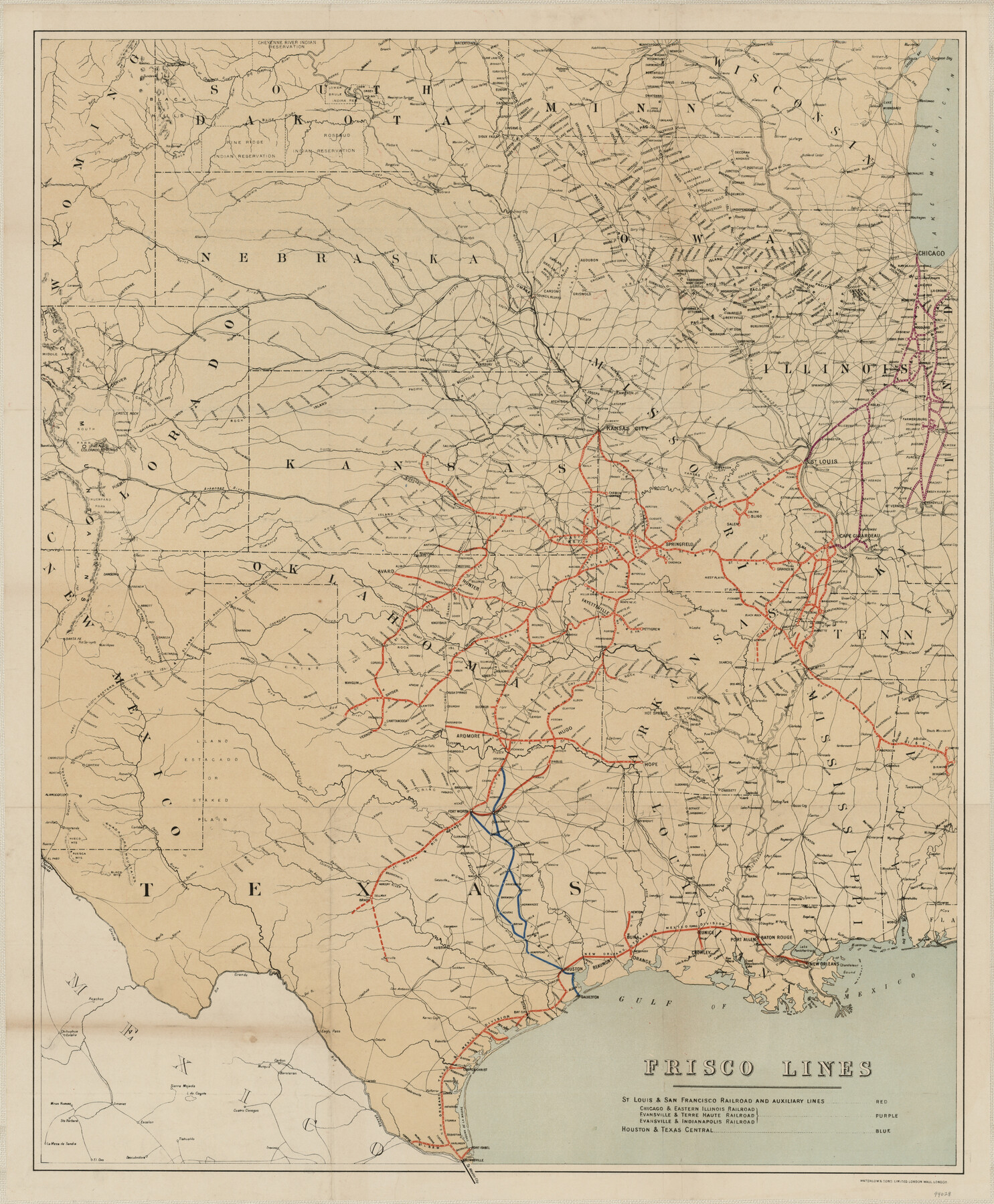
Frisco Lines
-
Map/Doc
94028
-
Collection
General Map Collection
-
Object Dates
[1890 ca.] (Creation Date)
-
People and Organizations
Waterlow & Sons Limited (Publisher)
-
Subjects
Railroads State of Texas
-
Height x Width
29.8 x 24.6 inches
75.7 x 62.5 cm
-
Medium
paper, etching/engraving/lithograph
Part of: General Map Collection
Jefferson County Sketch File 17

Print $4.00
- Digital $50.00
Jefferson County Sketch File 17
Size 7.9 x 8.1 inches
Map/Doc 28165
Travis County Appraisal District Plat Map 2_3216

Print $20.00
- Digital $50.00
Travis County Appraisal District Plat Map 2_3216
Size 21.5 x 26.4 inches
Map/Doc 94223
Briscoe County Working Sketch 6

Print $20.00
- Digital $50.00
Briscoe County Working Sketch 6
1940
Size 31.0 x 24.5 inches
Map/Doc 67809
Ellis County Sketch File 16

Print $4.00
- Digital $50.00
Ellis County Sketch File 16
Size 13.1 x 8.3 inches
Map/Doc 21858
Newton County Rolled Sketch 4

Print $20.00
- Digital $50.00
Newton County Rolled Sketch 4
1893
Size 21.1 x 19.7 inches
Map/Doc 6840
Pecos County Working Sketch 71

Print $20.00
- Digital $50.00
Pecos County Working Sketch 71
1957
Size 41.6 x 26.0 inches
Map/Doc 71543
Baylor County Sketch File 25

Print $46.00
- Digital $50.00
Baylor County Sketch File 25
1954
Size 11.5 x 9.0 inches
Map/Doc 14212
Gregg County Working Sketch 13

Print $20.00
- Digital $50.00
Gregg County Working Sketch 13
1940
Size 30.3 x 24.2 inches
Map/Doc 63280
No. 3 Chart of Channel connecting Corpus Christi Bay with Aransas Bay, Texas

Print $20.00
- Digital $50.00
No. 3 Chart of Channel connecting Corpus Christi Bay with Aransas Bay, Texas
1878
Size 18.3 x 28.0 inches
Map/Doc 72773
Brooks County Rolled Sketch 19

Print $84.00
- Digital $50.00
Brooks County Rolled Sketch 19
Size 43.3 x 59.2 inches
Map/Doc 8533
Runnels County Working Sketch 28

Print $20.00
- Digital $50.00
Runnels County Working Sketch 28
1959
Size 41.9 x 35.2 inches
Map/Doc 63624
Gonzales County Sketch File 1

Print $4.00
- Digital $50.00
Gonzales County Sketch File 1
1858
Size 8.1 x 10.2 inches
Map/Doc 24355
You may also like
Flight Mission No. BRE-1P, Frame 10, Nueces County

Print $20.00
- Digital $50.00
Flight Mission No. BRE-1P, Frame 10, Nueces County
1956
Size 18.4 x 22.5 inches
Map/Doc 86618
General Highway Map. Detail of Cities and Towns in Leon County, Texas

Print $20.00
General Highway Map. Detail of Cities and Towns in Leon County, Texas
1961
Size 18.1 x 24.8 inches
Map/Doc 79569
Old Miscellaneous File 27b

Print $10.00
- Digital $50.00
Old Miscellaneous File 27b
1880
Size 14.3 x 8.8 inches
Map/Doc 75722
Matagorda County Sketch File 3

Print $4.00
- Digital $50.00
Matagorda County Sketch File 3
1876
Size 12.9 x 8.0 inches
Map/Doc 30732
Stephens County Boundary File 1

Print $22.00
- Digital $50.00
Stephens County Boundary File 1
Size 14.1 x 8.9 inches
Map/Doc 58856
Map of Swisher Addition

Print $20.00
- Digital $50.00
Map of Swisher Addition
1910
Size 18.0 x 13.3 inches
Map/Doc 646
Brazoria County Rolled Sketch 18A

Print $20.00
- Digital $50.00
Brazoria County Rolled Sketch 18A
1913
Size 28.3 x 25.1 inches
Map/Doc 5164
Gonzales County Sketch File 12

Print $4.00
- Digital $50.00
Gonzales County Sketch File 12
Size 10.8 x 8.7 inches
Map/Doc 24394
Galveston County Sketch File 58

Print $20.00
- Digital $50.00
Galveston County Sketch File 58
1984
Size 47.1 x 38.3 inches
Map/Doc 10458
McMullen County Working Sketch 5

Print $20.00
- Digital $50.00
McMullen County Working Sketch 5
1923
Size 21.8 x 19.0 inches
Map/Doc 70706
Bee County Working Sketch 24

Print $20.00
- Digital $50.00
Bee County Working Sketch 24
1987
Size 36.6 x 24.0 inches
Map/Doc 67274
Working Sketch in Hutchinson County

Print $20.00
- Digital $50.00
Working Sketch in Hutchinson County
1932
Size 18.4 x 27.0 inches
Map/Doc 91164