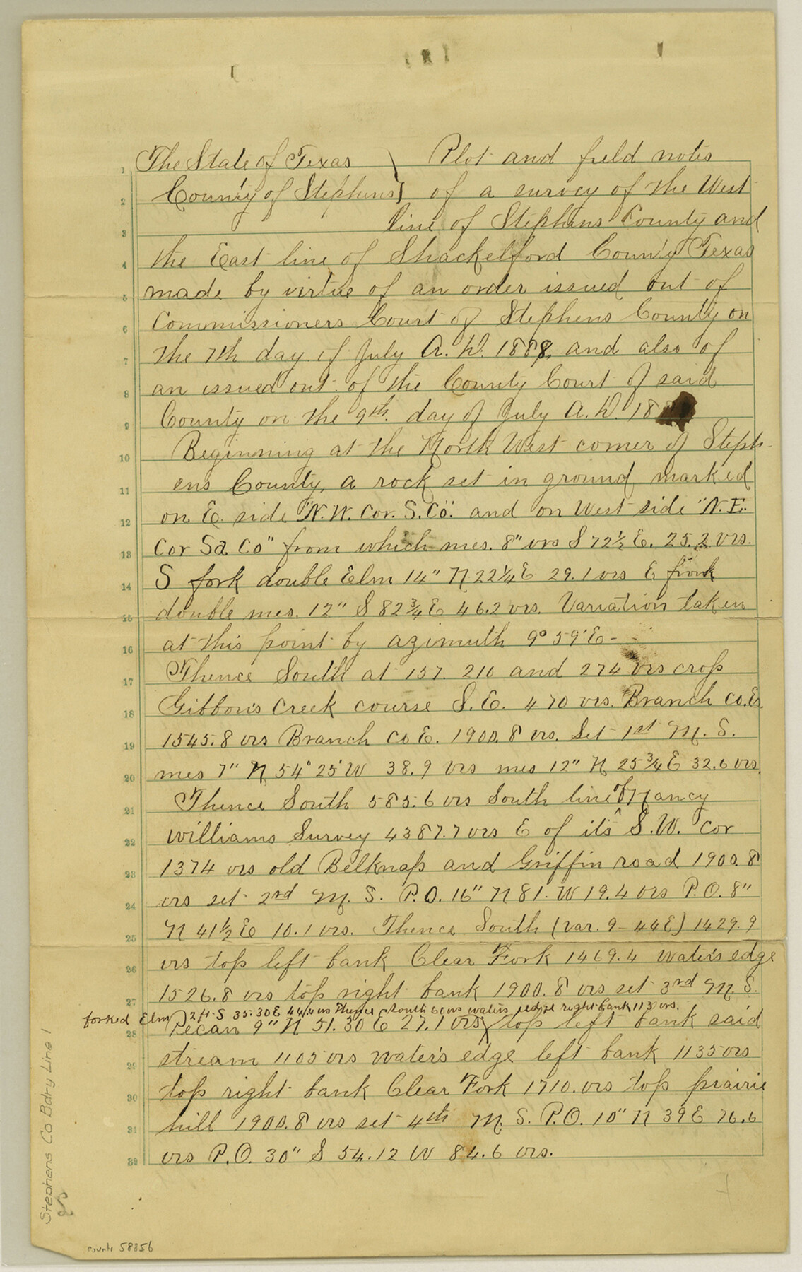
Stephens County Boundary File 1
Plat of W. Line of Stephens Co. & E. Line Shackelford Co.
-
Map/Doc
58856
-
Collection
General Map Collection
-
Counties
Stephens
-
Subjects
County Boundaries
-
Height x Width
14.1 x 8.9 inches
35.8 x 22.6 cm
Part of: General Map Collection
Lamar County Working Sketch 10

Print $20.00
- Digital $50.00
Lamar County Working Sketch 10
1980
Size 18.6 x 15.4 inches
Map/Doc 70271
Live Oak County Working Sketch 2

Print $20.00
- Digital $50.00
Live Oak County Working Sketch 2
1891
Size 17.9 x 18.2 inches
Map/Doc 70587
McLennan County

Print $20.00
- Digital $50.00
McLennan County
1946
Size 43.8 x 46.9 inches
Map/Doc 95585
Coryell County

Print $20.00
- Digital $50.00
Coryell County
1936
Size 45.4 x 41.4 inches
Map/Doc 95466
Young County Working Sketch 13

Print $20.00
- Digital $50.00
Young County Working Sketch 13
1938
Size 46.0 x 40.4 inches
Map/Doc 62036
Galveston County Sketch File 9

Print $6.00
- Digital $50.00
Galveston County Sketch File 9
1866
Size 10.1 x 8.1 inches
Map/Doc 23369
[Map of Uvalde County]
![4108, [Map of Uvalde County], General Map Collection](https://historictexasmaps.com/wmedia_w700/maps/4108.tif.jpg)
Print $20.00
- Digital $50.00
[Map of Uvalde County]
1862
Size 27.7 x 26.7 inches
Map/Doc 4108
Presidio County Rolled Sketch 102

Print $20.00
- Digital $50.00
Presidio County Rolled Sketch 102
1957
Size 19.3 x 13.8 inches
Map/Doc 7385
Flight Mission No. BQR-7K, Frame 30, Brazoria County

Print $20.00
- Digital $50.00
Flight Mission No. BQR-7K, Frame 30, Brazoria County
1952
Size 18.6 x 22.3 inches
Map/Doc 84028
Kimble County Working Sketch 55

Print $20.00
- Digital $50.00
Kimble County Working Sketch 55
1954
Size 14.3 x 30.1 inches
Map/Doc 70123
Hansford County Working Sketch 2

Print $40.00
- Digital $50.00
Hansford County Working Sketch 2
1934
Size 42.7 x 54.4 inches
Map/Doc 63374
Historical Sketch of the Rebellion

Print $20.00
- Digital $50.00
Historical Sketch of the Rebellion
1863
Size 22.4 x 21.0 inches
Map/Doc 96618
You may also like
[H. & G. N. Block 12 and surveys and blocks south]
![91610, [H. & G. N. Block 12 and surveys and blocks south], Twichell Survey Records](https://historictexasmaps.com/wmedia_w700/maps/91610-1.tif.jpg)
Print $20.00
- Digital $50.00
[H. & G. N. Block 12 and surveys and blocks south]
1907
Size 27.9 x 24.0 inches
Map/Doc 91610
Bexar County Working Sketch 10

Print $20.00
- Digital $50.00
Bexar County Working Sketch 10
1959
Size 22.6 x 34.5 inches
Map/Doc 67326
Morris County Rolled Sketch 2A

Print $20.00
- Digital $50.00
Morris County Rolled Sketch 2A
Size 35.2 x 27.7 inches
Map/Doc 10270
Jackson County Working Sketch Graphic Index

Print $20.00
- Digital $50.00
Jackson County Working Sketch Graphic Index
1920
Size 47.0 x 40.3 inches
Map/Doc 76590
Burnet County Rolled Sketch 2

Print $20.00
- Digital $50.00
Burnet County Rolled Sketch 2
1948
Size 15.5 x 30.5 inches
Map/Doc 5354
McMullen County Working Sketch 27

Print $40.00
- Digital $50.00
McMullen County Working Sketch 27
1953
Size 53.2 x 32.9 inches
Map/Doc 70728
Kerr County Working Sketch 37

Print $20.00
- Digital $50.00
Kerr County Working Sketch 37
1995
Size 19.0 x 24.0 inches
Map/Doc 70068
Coast Chart No. 209 - Aransas Pass, Aransas and Copano Bays, Texas

Print $20.00
- Digital $50.00
Coast Chart No. 209 - Aransas Pass, Aransas and Copano Bays, Texas
1889
Size 31.2 x 24.9 inches
Map/Doc 73429
Brooks County Rolled Sketch 21

Print $40.00
- Digital $50.00
Brooks County Rolled Sketch 21
1943
Size 51.5 x 41.3 inches
Map/Doc 8537
Lampasas County Working Sketch 10

Print $20.00
- Digital $50.00
Lampasas County Working Sketch 10
1963
Size 32.2 x 42.9 inches
Map/Doc 70287
Brazos River Conservation and Reclamation District Official Boundary Line Survey

Print $20.00
- Digital $50.00
Brazos River Conservation and Reclamation District Official Boundary Line Survey
Size 36.9 x 25.0 inches
Map/Doc 90251
Webb County Rolled Sketch 44

Print $20.00
- Digital $50.00
Webb County Rolled Sketch 44
1941
Size 23.9 x 20.1 inches
Map/Doc 8199