Baylor County Sketch File 25
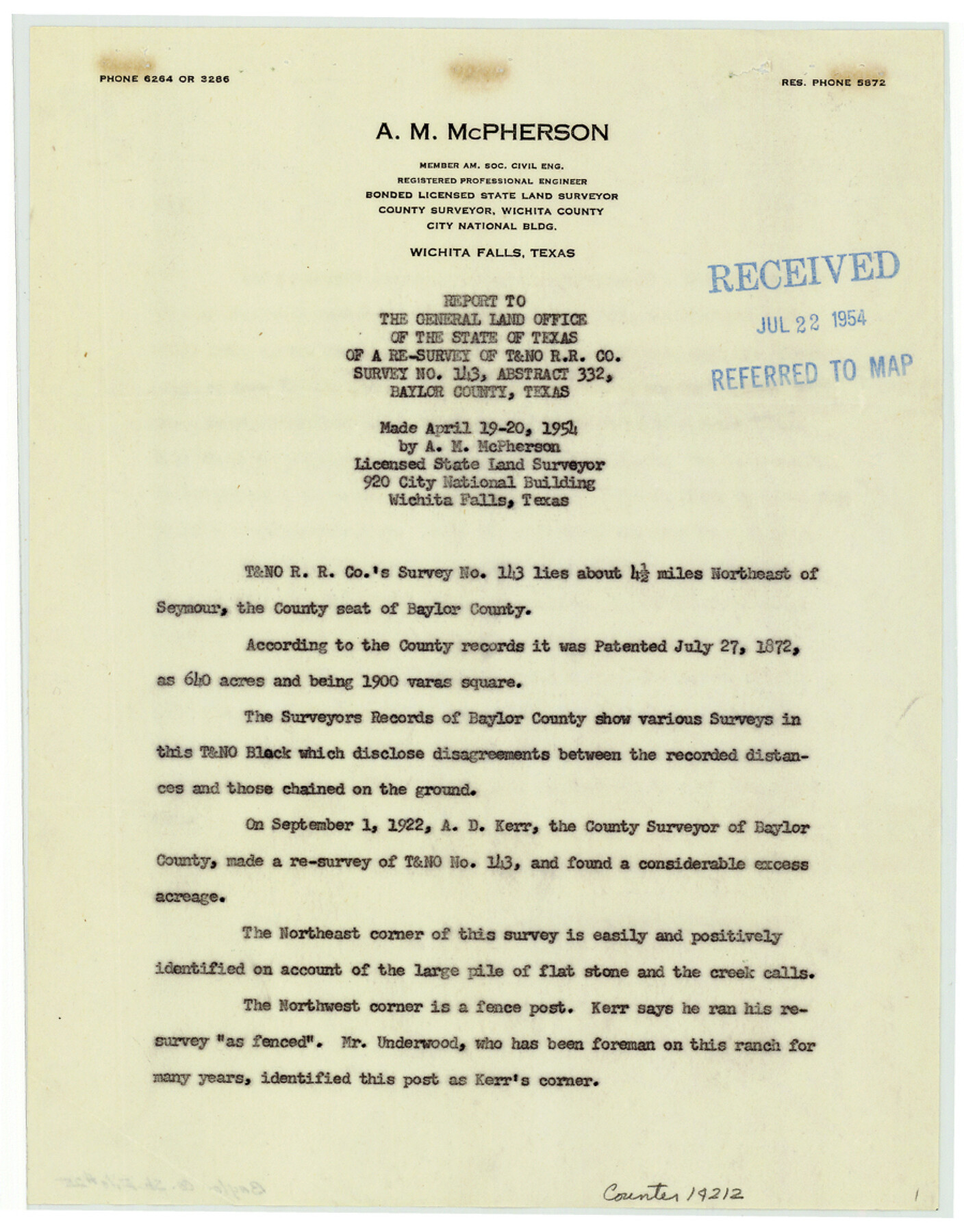
Report to the General Land Office of the State of Texas of a re-survey of T. & N. O. R.R. Co. survey no. 143, abstract 332, Baylor County, Texas [and accompanying sketch]
-
Map/Doc
14212
-
Collection
General Map Collection
-
Object Dates
1954/4/20 (Creation Date)
-
People and Organizations
A.D. Kerr (Surveyor/Engineer)
W.H. Martin (Surveyor/Engineer)
A.M. McPherson (Surveyor/Engineer)
-
Counties
Baylor
-
Subjects
Surveying Sketch File
-
Height x Width
11.5 x 9.0 inches
29.2 x 22.9 cm
-
Medium
multi-page, multi-format
Part of: General Map Collection
Brazos River, Widths of Floodways/Brazos and Navasota Rivers

Print $20.00
- Digital $50.00
Brazos River, Widths of Floodways/Brazos and Navasota Rivers
1921
Size 38.1 x 24.5 inches
Map/Doc 65292
Terry County Sketch File 13

Print $20.00
- Digital $50.00
Terry County Sketch File 13
Size 43.2 x 10.2 inches
Map/Doc 10397
No. 2 Chart of Corpus Christi Pass, Texas

Print $20.00
- Digital $50.00
No. 2 Chart of Corpus Christi Pass, Texas
1878
Size 18.2 x 27.3 inches
Map/Doc 73017
Flight Mission No. DCL-6C, Frame 175, Kenedy County

Print $20.00
- Digital $50.00
Flight Mission No. DCL-6C, Frame 175, Kenedy County
1943
Size 18.6 x 22.3 inches
Map/Doc 85987
Reagan County Rolled Sketch 10

Print $20.00
- Digital $50.00
Reagan County Rolled Sketch 10
1939
Size 18.7 x 15.8 inches
Map/Doc 7438
Hale County Sketch File 20

Print $6.00
- Digital $50.00
Hale County Sketch File 20
Size 15.7 x 10.5 inches
Map/Doc 24753
Flight Mission No. DQN-2K, Frame 124, Calhoun County

Print $20.00
- Digital $50.00
Flight Mission No. DQN-2K, Frame 124, Calhoun County
1953
Size 18.5 x 22.2 inches
Map/Doc 84300
Webb County State Real Property Sketch 1

Print $40.00
- Digital $50.00
Webb County State Real Property Sketch 1
1985
Size 23.4 x 17.7 inches
Map/Doc 61664
Terry County Rolled Sketch 2

Print $20.00
- Digital $50.00
Terry County Rolled Sketch 2
1908
Size 25.5 x 36.8 inches
Map/Doc 7980
Parker County Working Sketch 14

Print $20.00
- Digital $50.00
Parker County Working Sketch 14
1980
Map/Doc 71464
Survey plat of State Land, A. G. McMath No. 298, SF-10723 in El Paso County, Texas

Print $4.00
- Digital $50.00
Survey plat of State Land, A. G. McMath No. 298, SF-10723 in El Paso County, Texas
1984
Size 25.6 x 26.1 inches
Map/Doc 2254
Flight Mission No. CRE-2R, Frame 160, Jackson County

Print $20.00
- Digital $50.00
Flight Mission No. CRE-2R, Frame 160, Jackson County
1956
Size 18.5 x 22.3 inches
Map/Doc 85371
You may also like
Oldham County

Print $40.00
- Digital $50.00
Oldham County
1925
Size 43.6 x 53.5 inches
Map/Doc 66960
Harris County Sketch File 56

Print $4.00
- Digital $50.00
Harris County Sketch File 56
1918
Size 8.2 x 12.8 inches
Map/Doc 25454
Presidio County Sketch File 119

Print $14.00
- Digital $50.00
Presidio County Sketch File 119
1996
Size 14.3 x 9.0 inches
Map/Doc 34927
Tom Green County Boundary File 4

Print $70.00
- Digital $50.00
Tom Green County Boundary File 4
Size 8.8 x 6.8 inches
Map/Doc 59347
Sabine County Working Sketch 4

Print $20.00
- Digital $50.00
Sabine County Working Sketch 4
1913
Size 23.7 x 32.0 inches
Map/Doc 63675
Flight Mission No. DAG-21K, Frame 129, Matagorda County

Print $20.00
- Digital $50.00
Flight Mission No. DAG-21K, Frame 129, Matagorda County
1952
Size 18.6 x 22.5 inches
Map/Doc 86455

Refugio County Rolled Sketch 7

Print $20.00
- Digital $50.00
Refugio County Rolled Sketch 7
1946
Size 28.4 x 34.5 inches
Map/Doc 7508
Eastland County Rolled Sketch 3

Print $20.00
- Digital $50.00
Eastland County Rolled Sketch 3
1893
Size 24.4 x 41.3 inches
Map/Doc 5773
The Republic County of Colorado. December 29, 1845

Print $20.00
The Republic County of Colorado. December 29, 1845
2020
Size 18.4 x 21.7 inches
Map/Doc 96127
Dallas County Sketch File 19 1/2

Print $4.00
- Digital $50.00
Dallas County Sketch File 19 1/2
Size 9.9 x 8.2 inches
Map/Doc 20439
Hill County Sketch File 27

Print $4.00
- Digital $50.00
Hill County Sketch File 27
1873
Size 10.4 x 8.2 inches
Map/Doc 26528