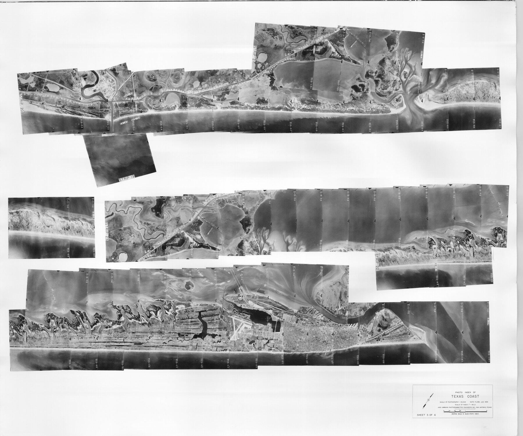
Photo Index of Texas Coast - Sheet 5 of 6
-
Map/Doc
83443
-
Collection
General Map Collection
-
Object Dates
1954 (Creation Date)
-
Subjects
Aerial Photograph
-
Height x Width
20.0 x 24.0 inches
50.8 x 61.0 cm
-
Comments
Statement on reverse side: "The reverse reflects the data shown thereon which was obtained by aerial survey made from December 31, 1953 to March 17, 1954 by Jack Ammann Photogrammetric Engineers, Inc."
Part of: General Map Collection
Kinney County Working Sketch 32

Print $20.00
- Digital $50.00
Kinney County Working Sketch 32
1961
Size 32.6 x 42.5 inches
Map/Doc 70214
Freestone County Sketch File 23

Print $6.00
- Digital $50.00
Freestone County Sketch File 23
1918
Size 11.4 x 8.9 inches
Map/Doc 23084
Flight Mission No. CRC-4R, Frame 101, Chambers County

Print $20.00
- Digital $50.00
Flight Mission No. CRC-4R, Frame 101, Chambers County
1956
Size 18.6 x 22.4 inches
Map/Doc 84898
Blanco County Working Sketch 15

Print $20.00
- Digital $50.00
Blanco County Working Sketch 15
1950
Size 23.5 x 20.7 inches
Map/Doc 67375
Jack County Sketch File 24

Print $4.00
- Digital $50.00
Jack County Sketch File 24
1880
Size 8.3 x 9.5 inches
Map/Doc 27561
Knox County Sketch File 10

Print $20.00
- Digital $50.00
Knox County Sketch File 10
1889
Size 20.1 x 12.8 inches
Map/Doc 11958
Uvalde County Boundary File 3

Print $28.00
- Digital $50.00
Uvalde County Boundary File 3
Size 13.1 x 8.4 inches
Map/Doc 59558
Flight Mission No. DIX-10P, Frame 170, Aransas County

Print $20.00
- Digital $50.00
Flight Mission No. DIX-10P, Frame 170, Aransas County
1956
Size 18.7 x 22.3 inches
Map/Doc 83960
Uvalde County Rolled Sketch 24

Print $20.00
- Digital $50.00
Uvalde County Rolled Sketch 24
2014
Size 16.2 x 16.1 inches
Map/Doc 93722
Archer County Working Sketch 19

Print $20.00
- Digital $50.00
Archer County Working Sketch 19
1960
Size 29.6 x 27.5 inches
Map/Doc 67160
Travis County Sketch File 32

Print $20.00
- Digital $50.00
Travis County Sketch File 32
Size 25.3 x 32.7 inches
Map/Doc 12460
Culberson County Working Sketch 63

Print $20.00
- Digital $50.00
Culberson County Working Sketch 63
1975
Size 34.1 x 24.9 inches
Map/Doc 68517
You may also like
Fort Bend County Sketch File 21

Print $4.00
- Digital $50.00
Fort Bend County Sketch File 21
1882
Size 8.8 x 13.4 inches
Map/Doc 22954
Lamar County State Real Property Sketch 1

Print $20.00
- Digital $50.00
Lamar County State Real Property Sketch 1
2013
Size 24.0 x 36.0 inches
Map/Doc 93656
From Citizens of Red River County for the Creation of a New County to be Called Aurora, December 3, 1840

Print $20.00
From Citizens of Red River County for the Creation of a New County to be Called Aurora, December 3, 1840
2020
Size 19.8 x 21.7 inches
Map/Doc 96391
Newton County Working Sketch 6

Print $20.00
- Digital $50.00
Newton County Working Sketch 6
1930
Size 35.5 x 25.9 inches
Map/Doc 71252
Hemphill County Rolled Sketch 4

Print $40.00
- Digital $50.00
Hemphill County Rolled Sketch 4
Size 29.7 x 55.1 inches
Map/Doc 6186
Montgomery County Working Sketch 52

Print $20.00
- Digital $50.00
Montgomery County Working Sketch 52
1960
Size 37.8 x 43.3 inches
Map/Doc 71159
Map of Main Line Houston & Tex. Centr. Railway from Dallas to Red River City

Print $40.00
- Digital $50.00
Map of Main Line Houston & Tex. Centr. Railway from Dallas to Red River City
Size 37.1 x 84.9 inches
Map/Doc 64089
Fannin County Sketch File 3

Print $4.00
- Digital $50.00
Fannin County Sketch File 3
Size 9.3 x 8.3 inches
Map/Doc 22447
Jeff Davis County Sketch File 44

Print $8.00
- Digital $50.00
Jeff Davis County Sketch File 44
1886
Size 8.5 x 8.0 inches
Map/Doc 28071
Frio County Rolled Sketch 17

Print $20.00
- Digital $50.00
Frio County Rolled Sketch 17
1953
Size 32.4 x 44.5 inches
Map/Doc 8907
Newton County Working Sketch 31

Print $20.00
- Digital $50.00
Newton County Working Sketch 31
1955
Size 34.3 x 43.6 inches
Map/Doc 71277
General Highway Map, Liberty County, Texas

Print $20.00
General Highway Map, Liberty County, Texas
1961
Size 18.2 x 24.7 inches
Map/Doc 79570