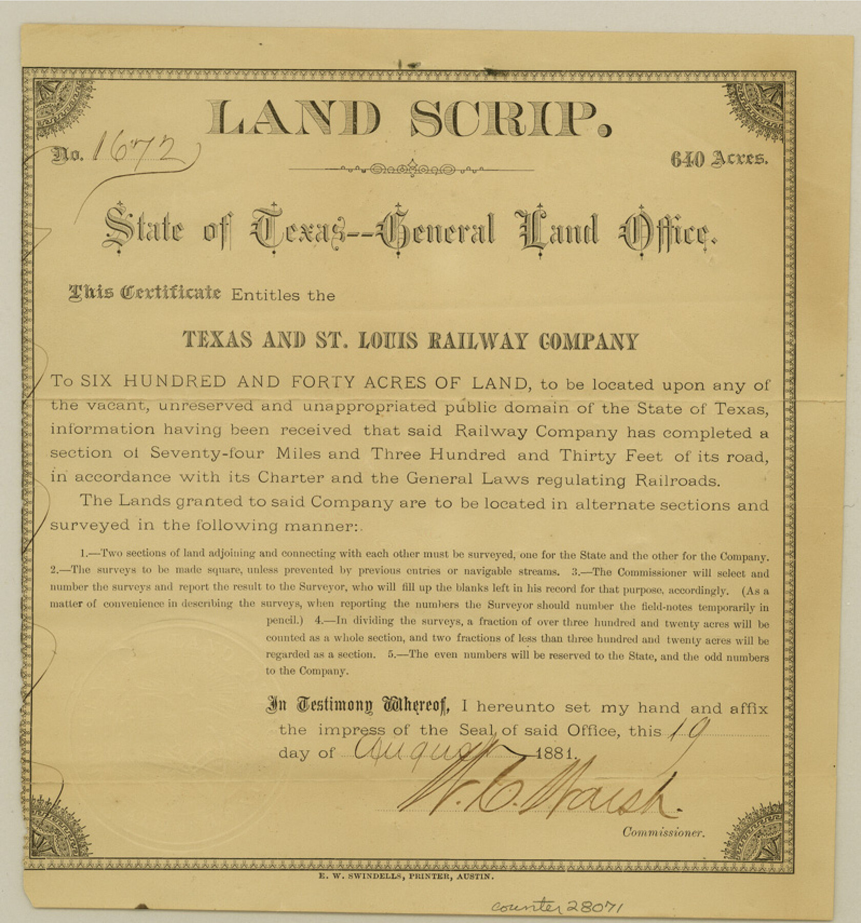
Jeff Davis County Sketch File 44
[Certificate and field notes for sections 21 and 22, T. & St. L. RR. Co., Block 2]
-
Map/Doc
28071
-
Collection
General Map Collection
-
Object Dates
7/16/1886 (Creation Date)
2/6/1985 (File Date)
7/12/1886 (Survey Date)
-
People and Organizations
Jno. P. Randolph (Surveyor/Engineer)
T.R. Owen (Surveyor/Engineer)
W.C. Walsh (GLO Commissioner)
F.A. Fritsch (Chainman)
John Whitaker (Chainman)
-
Counties
Jeff Davis El Paso
-
Subjects
Surveying Sketch File
-
Height x Width
8.5 x 8.0 inches
21.6 x 20.3 cm
-
Medium
paper, print with manuscript additions
Part of: General Map Collection
Flight Mission No. CGI-3N, Frame 125, Cameron County

Print $20.00
- Digital $50.00
Flight Mission No. CGI-3N, Frame 125, Cameron County
1954
Size 18.6 x 22.2 inches
Map/Doc 84598
McCulloch County Rolled Sketch 10

Print $20.00
- Digital $50.00
McCulloch County Rolled Sketch 10
Size 45.9 x 33.7 inches
Map/Doc 6720
Culberson County Rolled Sketch 69

Print $20.00
- Digital $50.00
Culberson County Rolled Sketch 69
Size 33.5 x 22.9 inches
Map/Doc 76425
Dallas County Sketch File 19 1/2

Print $4.00
- Digital $50.00
Dallas County Sketch File 19 1/2
Size 9.9 x 8.2 inches
Map/Doc 20439
In the Supreme Court of the United States The State of Oklahoma, Complainant vs. The State of Texas, Defendant, The United States of America, Intervener - 1921

Print $20.00
- Digital $50.00
In the Supreme Court of the United States The State of Oklahoma, Complainant vs. The State of Texas, Defendant, The United States of America, Intervener - 1921
1921
Size 24.4 x 32.4 inches
Map/Doc 75128
Oldham County Rolled Sketch 11

Print $40.00
- Digital $50.00
Oldham County Rolled Sketch 11
Size 48.6 x 39.9 inches
Map/Doc 10641
Leon County Rolled Sketch 32

Print $20.00
- Digital $50.00
Leon County Rolled Sketch 32
Size 34.2 x 40.7 inches
Map/Doc 6616
Webb County Sketch File 16

Print $20.00
- Digital $50.00
Webb County Sketch File 16
Size 37.1 x 24.5 inches
Map/Doc 12635
[Nueces Bay Islands and Nesting Birds]
![2084, [Nueces Bay Islands and Nesting Birds], General Map Collection](https://historictexasmaps.com/wmedia_w700/maps/2084.tif.jpg)
Print $20.00
- Digital $50.00
[Nueces Bay Islands and Nesting Birds]
1940
Size 18.1 x 24.2 inches
Map/Doc 2084
Jasper County Working Sketch 31

Print $20.00
- Digital $50.00
Jasper County Working Sketch 31
1963
Size 38.2 x 37.7 inches
Map/Doc 66493
Zavala County Working Sketch 30

Print $20.00
- Digital $50.00
Zavala County Working Sketch 30
1989
Size 36.8 x 28.1 inches
Map/Doc 62105
Rusk County Sketch File 43

Print $20.00
Rusk County Sketch File 43
1951
Size 23.5 x 26.6 inches
Map/Doc 12278
You may also like
Flight Mission No. BRE-2P, Frame 38, Nueces County

Print $20.00
- Digital $50.00
Flight Mission No. BRE-2P, Frame 38, Nueces County
1956
Size 18.7 x 22.7 inches
Map/Doc 86740
[A. B. & M. Block 2]
![91794, [A. B. & M. Block 2], Twichell Survey Records](https://historictexasmaps.com/wmedia_w700/maps/91794-1.tif.jpg)
Print $2.00
- Digital $50.00
[A. B. & M. Block 2]
Size 7.1 x 14.1 inches
Map/Doc 91794
St. Louis, Brownsville & Mexico Railway Location Map from Mile 80 to Mile 100

Print $40.00
- Digital $50.00
St. Louis, Brownsville & Mexico Railway Location Map from Mile 80 to Mile 100
1905
Size 19.4 x 60.9 inches
Map/Doc 64165
Field Notes of Mercer's Colony, Robertson, Nac[a]gdoches, Fannin, & Lamar Counties.
![1953, Field Notes of Mercer's Colony, Robertson, Nac[a]gdoches, Fannin, & Lamar Counties., General Map Collection](https://historictexasmaps.com/wmedia_w700/pdf_converted_jpg/qi_pdf_thumbnail_897.jpg)
Print $30.00
- Digital $50.00
Field Notes of Mercer's Colony, Robertson, Nac[a]gdoches, Fannin, & Lamar Counties.
1845
Size 9.5 x 14.8 inches
Map/Doc 1953
Presidio County Rolled Sketch 131A

Print $40.00
- Digital $50.00
Presidio County Rolled Sketch 131A
1991
Size 37.6 x 49.7 inches
Map/Doc 10713
Stonewall County Rolled Sketch 20

Print $40.00
- Digital $50.00
Stonewall County Rolled Sketch 20
Size 36.7 x 55.7 inches
Map/Doc 49129
The Republic County of Jackson. December 24, 1844

Print $20.00
The Republic County of Jackson. December 24, 1844
2020
Size 15.6 x 21.8 inches
Map/Doc 96191
Hays County State Real Property Sketch 3

Print $20.00
- Digital $50.00
Hays County State Real Property Sketch 3
2003
Size 24.0 x 37.2 inches
Map/Doc 96638
General Highway Map Travis County

Print $20.00
- Digital $50.00
General Highway Map Travis County
1952
Size 17.2 x 12.5 inches
Map/Doc 92288
[Surveying Sketch of Francisco Guerra, Antonio Ramirez, Diego Ynojosa, et al on Rio Grande, Starr County]
![5073, [Surveying Sketch of Francisco Guerra, Antonio Ramirez, Diego Ynojosa, et al on Rio Grande, Starr County], Maddox Collection](https://historictexasmaps.com/wmedia_w700/maps/5073-1.tif.jpg)
Print $20.00
- Digital $50.00
[Surveying Sketch of Francisco Guerra, Antonio Ramirez, Diego Ynojosa, et al on Rio Grande, Starr County]
1914
Size 21.7 x 13.0 inches
Map/Doc 5073
Edwards County Working Sketch 34

Print $20.00
- Digital $50.00
Edwards County Working Sketch 34
1948
Size 39.2 x 23.3 inches
Map/Doc 68910
Sabine Bank to East Bay including Heald Bank

Print $20.00
- Digital $50.00
Sabine Bank to East Bay including Heald Bank
1946
Size 44.8 x 33.9 inches
Map/Doc 69845