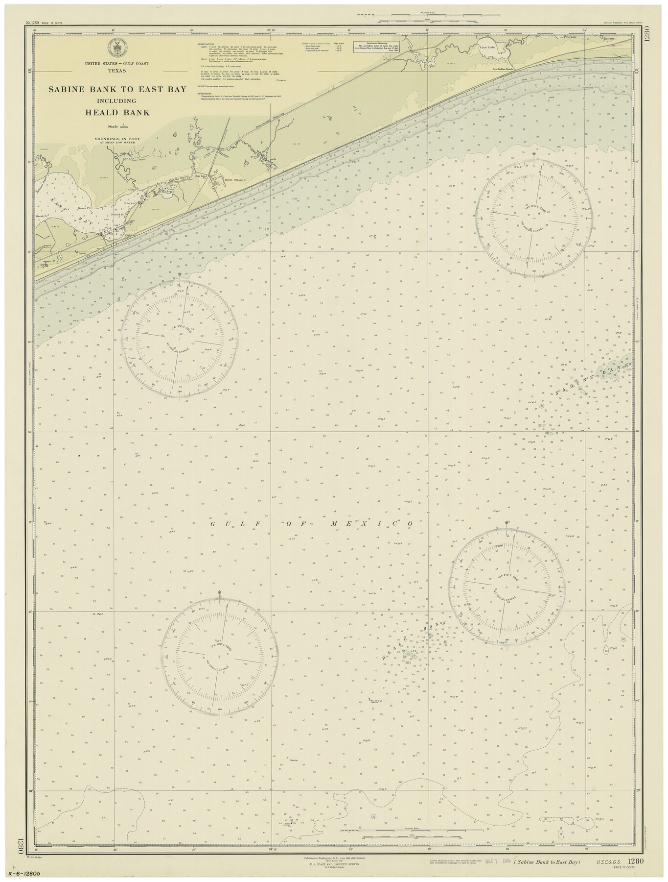
Sabine Bank to East Bay including Heald Bank
K-6-1280
-
Map/Doc
69845
-
Collection
General Map Collection
-
Object Dates
8/10/1946 (Creation Date)
-
Counties
Jefferson Galveston Chambers
-
Subjects
Nautical Charts
-
Height x Width
44.8 x 33.9 inches
113.8 x 86.1 cm
Part of: General Map Collection
[Right of Way and Track Map, the Missouri, Kansas and Texas Ry. of Texas - Henrietta Division]
![64760, [Right of Way and Track Map, the Missouri, Kansas and Texas Ry. of Texas - Henrietta Division], General Map Collection](https://historictexasmaps.com/wmedia_w700/maps/64760.tif.jpg)
Print $20.00
- Digital $50.00
[Right of Way and Track Map, the Missouri, Kansas and Texas Ry. of Texas - Henrietta Division]
1918
Size 11.8 x 26.9 inches
Map/Doc 64760
San Patricio County Working Sketch 26

Print $20.00
- Digital $50.00
San Patricio County Working Sketch 26
1986
Size 29.0 x 34.4 inches
Map/Doc 63788
Orange County Working Sketch 27

Print $20.00
- Digital $50.00
Orange County Working Sketch 27
1953
Size 31.0 x 22.9 inches
Map/Doc 71359
Angelina County Sketch File 15d

Print $20.00
- Digital $50.00
Angelina County Sketch File 15d
1863
Size 8.0 x 6.6 inches
Map/Doc 12980
Harrison County Sketch File 19

Print $20.00
- Digital $50.00
Harrison County Sketch File 19
1954
Size 25.0 x 21.7 inches
Map/Doc 11692
Fractional Township No. 9 South Range No. 1 East of the Indian Meridian, Indian Territory

Print $20.00
- Digital $50.00
Fractional Township No. 9 South Range No. 1 East of the Indian Meridian, Indian Territory
1898
Size 19.2 x 24.4 inches
Map/Doc 75201
Approaches to Galveston Bay

Print $40.00
- Digital $50.00
Approaches to Galveston Bay
1973
Size 49.8 x 35.6 inches
Map/Doc 69882
[Sketch for Mineral Application 13440]
![65673, [Sketch for Mineral Application 13440], General Map Collection](https://historictexasmaps.com/wmedia_w700/maps/65673-1.tif.jpg)
Print $40.00
- Digital $50.00
[Sketch for Mineral Application 13440]
Size 42.4 x 66.0 inches
Map/Doc 65673
Cooke County Working Sketch Graphic Index

Print $20.00
- Digital $50.00
Cooke County Working Sketch Graphic Index
1935
Size 44.7 x 38.2 inches
Map/Doc 76504
Flight Mission No. CRC-4R, Frame 77, Chambers County

Print $20.00
- Digital $50.00
Flight Mission No. CRC-4R, Frame 77, Chambers County
1956
Size 18.9 x 22.5 inches
Map/Doc 84881
Anderson County Working Sketch 42

Print $40.00
- Digital $50.00
Anderson County Working Sketch 42
1987
Size 34.4 x 51.1 inches
Map/Doc 67042
Upper Galveston Bay, Houston Ship Channel, Dollar Pt. to Atkinson I.

Print $40.00
- Digital $50.00
Upper Galveston Bay, Houston Ship Channel, Dollar Pt. to Atkinson I.
1972
Size 49.9 x 36.9 inches
Map/Doc 69895
You may also like

Reagan County Rolled Sketch 5

Print $20.00
- Digital $50.00
Reagan County Rolled Sketch 5
1928
Size 26.8 x 22.1 inches
Map/Doc 7434
Hamilton County Rolled Sketch 11

Print $20.00
- Digital $50.00
Hamilton County Rolled Sketch 11
Size 20.1 x 14.1 inches
Map/Doc 6060


National Map Company's New Road Survey of the United States Showing Main Highways

Digital $50.00
National Map Company's New Road Survey of the United States Showing Main Highways
Size 44.5 x 38.2 inches
Map/Doc 4659
Current Miscellaneous File 20

Print $22.00
- Digital $50.00
Current Miscellaneous File 20
1952
Size 10.7 x 8.1 inches
Map/Doc 73855
Harrison County Sketch File 3

Print $8.00
- Digital $50.00
Harrison County Sketch File 3
Size 13.0 x 8.3 inches
Map/Doc 26036
General Highway Map, Dimmit County, La Salle County, Texas

Print $20.00
General Highway Map, Dimmit County, La Salle County, Texas
1940
Size 18.4 x 25.2 inches
Map/Doc 79077
Right of Way and Track Map, the Missouri, Kansas and Texas Ry. of Texas operated by the Missouri, Kansas and Texas Ry. of Texas, San Antonio Division

Print $40.00
- Digital $50.00
Right of Way and Track Map, the Missouri, Kansas and Texas Ry. of Texas operated by the Missouri, Kansas and Texas Ry. of Texas, San Antonio Division
1918
Size 25.3 x 58.3 inches
Map/Doc 64579
San Augustine County Working Sketch 17

Print $20.00
- Digital $50.00
San Augustine County Working Sketch 17
1963
Size 20.3 x 21.5 inches
Map/Doc 63705
Flight Mission No. BRA-6M, Frame 89, Jefferson County

Print $20.00
- Digital $50.00
Flight Mission No. BRA-6M, Frame 89, Jefferson County
1953
Size 18.6 x 22.4 inches
Map/Doc 85432