Kimble County Sketch File 3
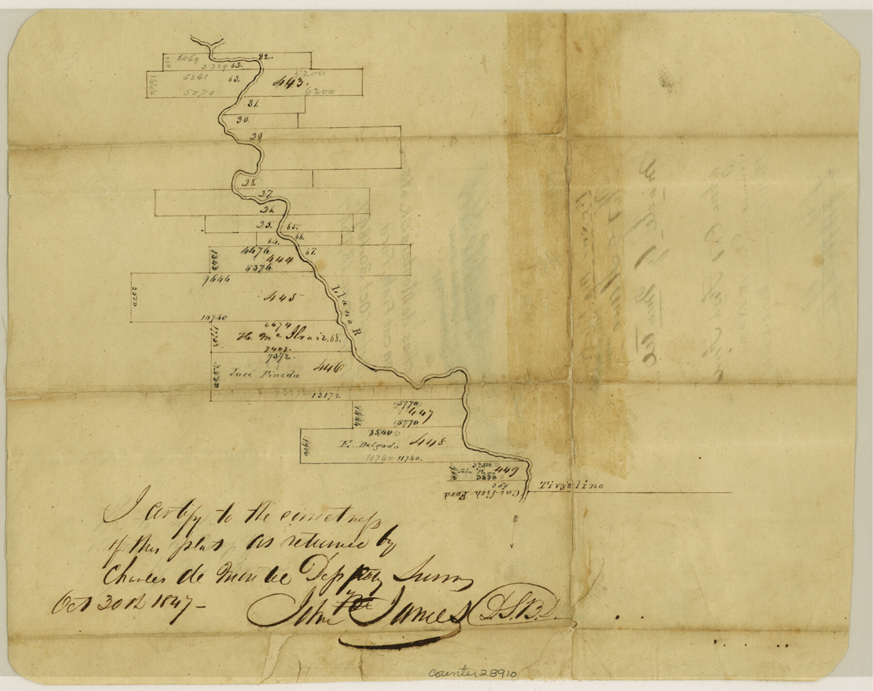
[Sketch of surveys on Llano River east of Junction]
-
Map/Doc
28910
-
Collection
General Map Collection
-
Object Dates
10/30/1847 (Creation Date)
12/18/1847 (File Date)
-
People and Organizations
Charles de Montel (Surveyor/Engineer)
-
Counties
Kimble
-
Subjects
Surveying Sketch File
-
Height x Width
9.1 x 11.5 inches
23.1 x 29.2 cm
-
Medium
paper, manuscript
-
Features
Llano River
Catfish Ford
Part of: General Map Collection
Palo Pinto County Sketch File 7

Print $4.00
- Digital $50.00
Palo Pinto County Sketch File 7
1870
Size 13.0 x 8.2 inches
Map/Doc 33398
Burnet County Boundary File 7

Print $36.00
- Digital $50.00
Burnet County Boundary File 7
Size 14.0 x 8.5 inches
Map/Doc 50893
Red River County Rolled Sketch 3

Print $20.00
- Digital $50.00
Red River County Rolled Sketch 3
Size 36.9 x 31.0 inches
Map/Doc 9840
Houston including Bellaire, Bunker Hill, Galena Park, Hedwig, Hilshire, Hunters Creek, Jacinto City, Jersey Village, Missouri City, Pasadena, Piney Point, South Houston, Spring Valley, West University Place and adjoining communities [Verso]
![94180, Houston including Bellaire, Bunker Hill, Galena Park, Hedwig, Hilshire, Hunters Creek, Jacinto City, Jersey Village, Missouri City, Pasadena, Piney Point, South Houston, Spring Valley, West University Place and adjoining communities [Verso], General Map Collection](https://historictexasmaps.com/wmedia_w700/maps/94180.tif.jpg)
Houston including Bellaire, Bunker Hill, Galena Park, Hedwig, Hilshire, Hunters Creek, Jacinto City, Jersey Village, Missouri City, Pasadena, Piney Point, South Houston, Spring Valley, West University Place and adjoining communities [Verso]
Size 27.1 x 42.4 inches
Map/Doc 94180
Hardin County Working Sketch 23

Print $20.00
- Digital $50.00
Hardin County Working Sketch 23
1950
Size 20.7 x 29.4 inches
Map/Doc 63421
Pecos County Working Sketch Graphic index - northwest part - sheet A

Print $20.00
- Digital $50.00
Pecos County Working Sketch Graphic index - northwest part - sheet A
1975
Size 42.2 x 42.6 inches
Map/Doc 76663
Ward County Working Sketch 27

Print $40.00
- Digital $50.00
Ward County Working Sketch 27
1964
Size 52.7 x 27.3 inches
Map/Doc 72333
Flight Mission No. DCL-6C, Frame 29, Kenedy County

Print $20.00
- Digital $50.00
Flight Mission No. DCL-6C, Frame 29, Kenedy County
1943
Size 18.6 x 22.4 inches
Map/Doc 85886


Harris County Rolled Sketch 60

Print $20.00
- Digital $50.00
Harris County Rolled Sketch 60
1927
Size 27.4 x 21.3 inches
Map/Doc 6106
San Patricio County Sketch File 24

Print $10.00
San Patricio County Sketch File 24
1918
Size 10.0 x 4.3 inches
Map/Doc 36078
You may also like
Chambers County Working Sketch 8

Print $20.00
- Digital $50.00
Chambers County Working Sketch 8
1940
Size 20.9 x 44.4 inches
Map/Doc 67991
[E. L. & R. R. Block 10]
![91352, [E. L. & R. R. Block 10], Twichell Survey Records](https://historictexasmaps.com/wmedia_w700/maps/91352-1.tif.jpg)
Print $20.00
- Digital $50.00
[E. L. & R. R. Block 10]
Size 25.6 x 15.8 inches
Map/Doc 91352
[Note to Thos. W. Ward to make corrections for J. D. Wheeler, Survey 147 in San Patricio County, San Patricio District]
![69748, [Note to Thos. W. Ward to make corrections for J. D. Wheeler, Survey 147 in San Patricio County, San Patricio District], General Map Collection](https://historictexasmaps.com/wmedia_w700/maps/69748.tif.jpg)
Print $2.00
- Digital $50.00
[Note to Thos. W. Ward to make corrections for J. D. Wheeler, Survey 147 in San Patricio County, San Patricio District]
1842
Size 4.5 x 6.8 inches
Map/Doc 69748
Flight Mission No. BQY-4M, Frame 41, Harris County

Print $20.00
- Digital $50.00
Flight Mission No. BQY-4M, Frame 41, Harris County
1953
Size 18.6 x 22.4 inches
Map/Doc 85256
Henderson County Working Sketch 35

Print $20.00
- Digital $50.00
Henderson County Working Sketch 35
1963
Size 19.3 x 38.1 inches
Map/Doc 66168
Flight Mission No. BRA-7M, Frame 20, Jefferson County

Print $20.00
- Digital $50.00
Flight Mission No. BRA-7M, Frame 20, Jefferson County
1953
Size 18.6 x 22.2 inches
Map/Doc 85471
Hall County Working Sketch 1

Print $20.00
- Digital $50.00
Hall County Working Sketch 1
Size 19.5 x 18.0 inches
Map/Doc 63329
General Highway Map. Detail of Cities and Towns in Dallas County, Texas [Dallas and vicinity]
![79431, General Highway Map. Detail of Cities and Towns in Dallas County, Texas [Dallas and vicinity], Texas State Library and Archives](https://historictexasmaps.com/wmedia_w700/maps/79431.tif.jpg)
Print $20.00
General Highway Map. Detail of Cities and Towns in Dallas County, Texas [Dallas and vicinity]
1961
Size 18.1 x 24.4 inches
Map/Doc 79431
Calhoun County Working Sketch 10

Print $20.00
- Digital $50.00
Calhoun County Working Sketch 10
1951
Size 36.8 x 37.2 inches
Map/Doc 67826
Ochiltree County Boundary File 10

Print $24.00
- Digital $50.00
Ochiltree County Boundary File 10
Size 11.2 x 8.7 inches
Map/Doc 57728
Sherman County Sketch File 1

Print $20.00
- Digital $50.00
Sherman County Sketch File 1
1923
Size 25.3 x 25.4 inches
Map/Doc 12322
General Highway Map, El Paso County, Texas

Print $20.00
General Highway Map, El Paso County, Texas
1961
Size 18.2 x 24.8 inches
Map/Doc 79458