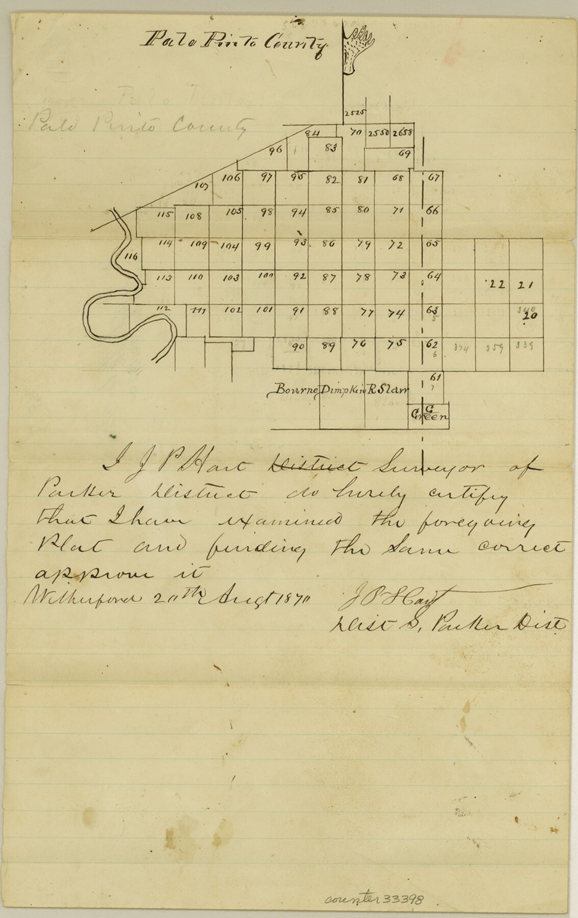
Palo Pinto County Sketch File 7
[Sketch northeast of Palo Pinto in Block A]
-
Map/Doc
33398
-
Collection
General Map Collection
-
Object Dates
8/20/1870 (Creation Date)
-
People and Organizations
J.P. Hart (Surveyor/Engineer)
-
Counties
Palo Pinto Parker
-
Subjects
Surveying Sketch File
-
Height x Width
13.0 x 8.2 inches
33.0 x 20.8 cm
-
Medium
paper, manuscript
Part of: General Map Collection
Harris County Boundary File 3

Print $16.00
- Digital $50.00
Harris County Boundary File 3
Size 14.7 x 7.0 inches
Map/Doc 54298

Liberty County Working Sketch 78

Print $20.00
- Digital $50.00
Liberty County Working Sketch 78
1981
Size 36.2 x 41.0 inches
Map/Doc 70538
Red River County Sketch File 14

Print $8.00
- Digital $50.00
Red River County Sketch File 14
Size 13.7 x 9.0 inches
Map/Doc 35133
Briscoe County Boundary File 3

Print $4.00
- Digital $50.00
Briscoe County Boundary File 3
Size 13.9 x 8.5 inches
Map/Doc 50778
Val Verde County Working Sketch 44

Print $40.00
- Digital $50.00
Val Verde County Working Sketch 44
1945
Size 49.7 x 39.5 inches
Map/Doc 72179
Map of Maverick County

Print $20.00
- Digital $50.00
Map of Maverick County
1892
Size 34.4 x 21.2 inches
Map/Doc 3852
Morris County Rolled Sketch 2A

Print $20.00
- Digital $50.00
Morris County Rolled Sketch 2A
Size 24.0 x 18.8 inches
Map/Doc 10252
[Letters to and from Maj. W. J. Powell regarding surveys of Texas and Pacific Ry. Lands west of the Pecos. Blks 53-55, Township 1 & 2 map within]
![2249, [Letters to and from Maj. W. J. Powell regarding surveys of Texas and Pacific Ry. Lands west of the Pecos. Blks 53-55, Township 1 & 2 map within], General Map Collection](https://historictexasmaps.com/wmedia_w700/pdf_converted_jpg/qi_pdf_thumbnail_1039.jpg)
Print $124.00
- Digital $50.00
[Letters to and from Maj. W. J. Powell regarding surveys of Texas and Pacific Ry. Lands west of the Pecos. Blks 53-55, Township 1 & 2 map within]
1934
Size 10.2 x 15.4 inches
Map/Doc 2249
Parker County Sketch File 24

Print $4.00
- Digital $50.00
Parker County Sketch File 24
Size 8.6 x 13.0 inches
Map/Doc 33564
Township 4 North Range 13 West, North Western District, Louisiana

Print $20.00
- Digital $50.00
Township 4 North Range 13 West, North Western District, Louisiana
1884
Size 19.6 x 24.6 inches
Map/Doc 65866
Harrison County Working Sketch 5

Print $20.00
- Digital $50.00
Harrison County Working Sketch 5
1953
Size 39.7 x 39.8 inches
Map/Doc 66025
You may also like

Harris County NRC Article 33.136 Sketch 19

Print $50.00
- Digital $50.00
Harris County NRC Article 33.136 Sketch 19
2014
Size 24.6 x 36.6 inches
Map/Doc 95334
Map of Panola County

Print $20.00
- Digital $50.00
Map of Panola County
1882
Size 20.9 x 22.0 inches
Map/Doc 4504
Gaines County Rolled Sketch 9

Print $20.00
- Digital $50.00
Gaines County Rolled Sketch 9
Size 20.9 x 29.8 inches
Map/Doc 5929
[Subdivision plat of Crockett County School Land Leagues 214-217 and adjacent leagues]
![90245, [Subdivision plat of Crockett County School Land Leagues 214-217 and adjacent leagues], Twichell Survey Records](https://historictexasmaps.com/wmedia_w700/maps/90245-1.tif.jpg)
Print $20.00
- Digital $50.00
[Subdivision plat of Crockett County School Land Leagues 214-217 and adjacent leagues]
Size 26.8 x 18.8 inches
Map/Doc 90245
[Jose Ostane survey]
![89983, [Jose Ostane survey], Twichell Survey Records](https://historictexasmaps.com/wmedia_w700/maps/89983-1.tif.jpg)
Print $3.00
- Digital $50.00
[Jose Ostane survey]
Size 14.6 x 9.3 inches
Map/Doc 89983
[Leagues 11 and 22]
![91111, [Leagues 11 and 22], Twichell Survey Records](https://historictexasmaps.com/wmedia_w700/maps/91111-1.tif.jpg)
Print $20.00
- Digital $50.00
[Leagues 11 and 22]
1925
Size 14.0 x 13.6 inches
Map/Doc 91111
Hockley County Sketch File 10

Print $6.00
- Digital $50.00
Hockley County Sketch File 10
1921
Size 11.2 x 8.8 inches
Map/Doc 26541
Comal County Rolled Sketch 3

Print $20.00
- Digital $50.00
Comal County Rolled Sketch 3
1977
Size 19.0 x 17.3 inches
Map/Doc 5538

Starr County Rolled Sketch 42

Print $20.00
- Digital $50.00
Starr County Rolled Sketch 42
1972
Size 26.0 x 18.4 inches
Map/Doc 7835
