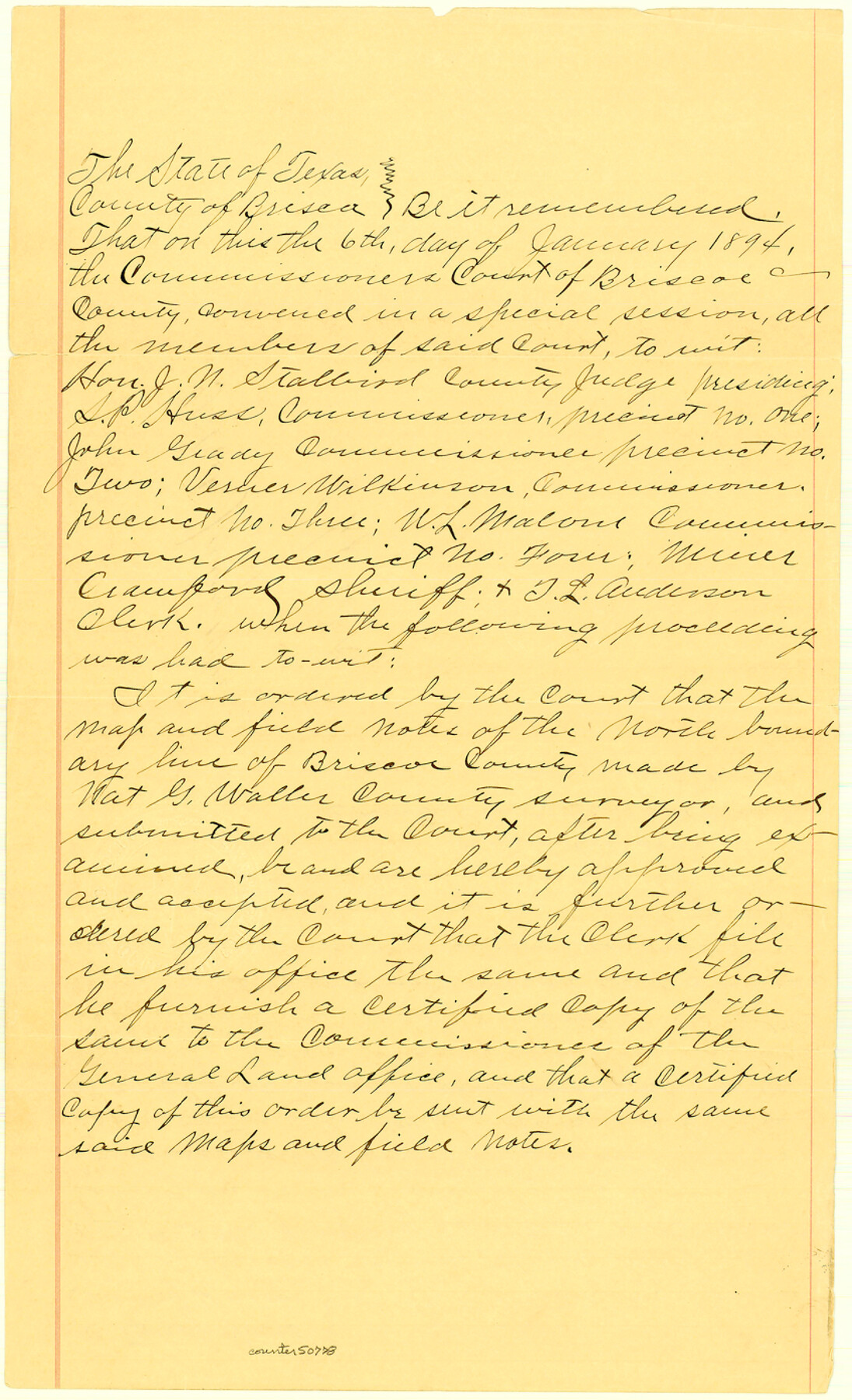
Briscoe County Boundary File 3
Court Order: North Boundary of Briscoe County
-
Map/Doc
50778
-
Collection
General Map Collection
-
Counties
Briscoe
-
Subjects
County Boundaries
-
Height x Width
13.9 x 8.5 inches
35.3 x 21.6 cm
Part of: General Map Collection
Glasscock County Rolled Sketch 3

Print $20.00
- Digital $50.00
Glasscock County Rolled Sketch 3
1906
Size 19.0 x 13.7 inches
Map/Doc 6014
Navarro County Sketch File 21

Print $4.00
- Digital $50.00
Navarro County Sketch File 21
1859
Size 9.0 x 8.4 inches
Map/Doc 32350
Clay County Boundary File 6

Print $2.00
- Digital $50.00
Clay County Boundary File 6
Size 8.1 x 3.5 inches
Map/Doc 51376
Jack County Sketch File 18c

Print $60.00
- Digital $50.00
Jack County Sketch File 18c
Size 20.0 x 30.7 inches
Map/Doc 11828
Lynn County Boundary File 12

Print $60.00
- Digital $50.00
Lynn County Boundary File 12
Size 14.0 x 17.5 inches
Map/Doc 56749
Val Verde County Sketch File XXX10

Print $20.00
- Digital $50.00
Val Verde County Sketch File XXX10
Size 25.9 x 19.2 inches
Map/Doc 12549
Sutton County Sketch File 27

Print $20.00
- Digital $50.00
Sutton County Sketch File 27
Size 38.8 x 15.1 inches
Map/Doc 10377
Map of Ellis County

Print $20.00
- Digital $50.00
Map of Ellis County
1857
Size 37.7 x 21.4 inches
Map/Doc 4536
Blanco County Sketch File 23

Print $16.00
- Digital $50.00
Blanco County Sketch File 23
1887
Size 8.7 x 14.1 inches
Map/Doc 14606

Shackelford County Working Sketch 1

Print $20.00
- Digital $50.00
Shackelford County Working Sketch 1
Size 15.1 x 18.4 inches
Map/Doc 63841
Corpus Christi Bay

Print $20.00
- Digital $50.00
Corpus Christi Bay
1961
Size 36.0 x 47.4 inches
Map/Doc 73471
You may also like
Texas Prospectors and Historians Map

Digital $50.00
Texas Prospectors and Historians Map
Size 22.4 x 29.2 inches
Map/Doc 94411
United States Including California, Texas, and c.

Print $20.00
United States Including California, Texas, and c.
1861
Size 21.4 x 25.7 inches
Map/Doc 76238
Atascosa County Working Sketch 15

Print $40.00
- Digital $50.00
Atascosa County Working Sketch 15
1935
Size 43.8 x 53.6 inches
Map/Doc 67211
Yoakum County Sketch File 17

Print $48.00
- Digital $50.00
Yoakum County Sketch File 17
1898
Size 14.5 x 8.9 inches
Map/Doc 40796
Morris County Rolled Sketch 2A

Print $20.00
- Digital $50.00
Morris County Rolled Sketch 2A
Size 24.3 x 19.2 inches
Map/Doc 10255
Wharton County Working Sketch 18

Print $20.00
- Digital $50.00
Wharton County Working Sketch 18
1948
Size 19.3 x 17.0 inches
Map/Doc 72482
Harris County Working Sketch 5

Print $20.00
- Digital $50.00
Harris County Working Sketch 5
Size 35.1 x 28.0 inches
Map/Doc 65897
Presidio County Working Sketch 10

Print $40.00
- Digital $50.00
Presidio County Working Sketch 10
1940
Size 42.1 x 67.1 inches
Map/Doc 71685
Whitharral Located on West Half of Labor 11, Capitol League 716 Hockley County, Texas

Print $20.00
- Digital $50.00
Whitharral Located on West Half of Labor 11, Capitol League 716 Hockley County, Texas
Size 17.5 x 20.9 inches
Map/Doc 92261
Limestone County Sketch File 2

Print $2.00
- Digital $50.00
Limestone County Sketch File 2
Size 8.0 x 6.2 inches
Map/Doc 30157
Morris County Rolled Sketch 2A

Print $3.00
- Digital $50.00
Morris County Rolled Sketch 2A
Size 12.1 x 10.5 inches
Map/Doc 10233
Northern Part of Laguna Madre

Print $20.00
- Digital $50.00
Northern Part of Laguna Madre
1968
Size 44.4 x 34.5 inches
Map/Doc 73528