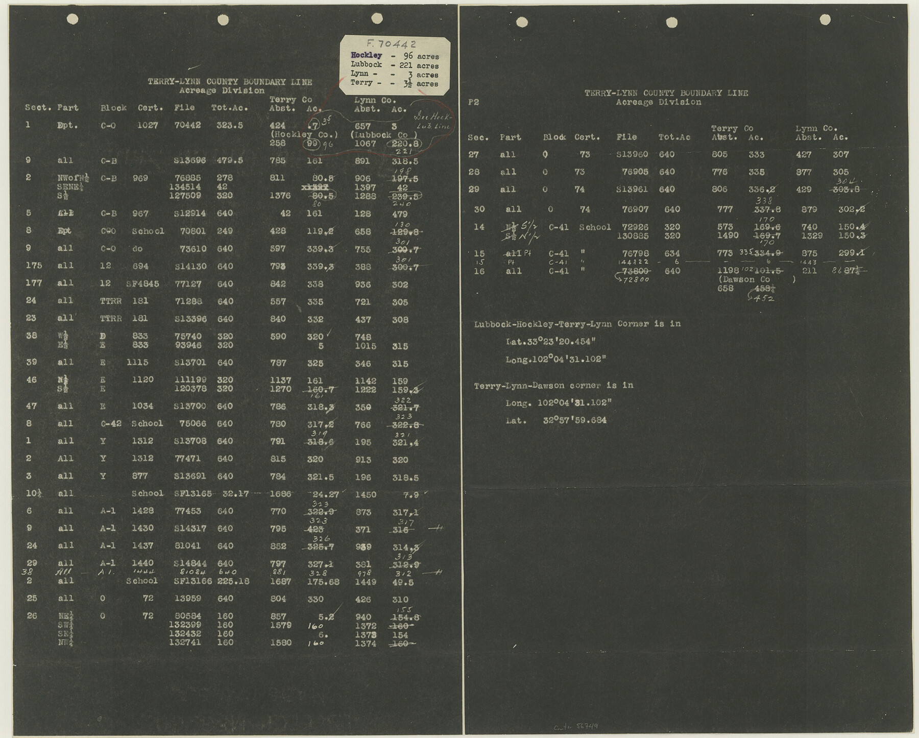
Lynn County Boundary File 12
Terry-Lynn County Boundary Line Acreage Division, Abstracted 1-16-35
-
Map/Doc
56749
-
Collection
General Map Collection
-
Counties
Lynn
-
Subjects
County Boundaries
-
Height x Width
14.0 x 17.5 inches
35.6 x 44.5 cm
Part of: General Map Collection
Nueces County Sketch File 21

Print $8.00
- Digital $50.00
Nueces County Sketch File 21
1880
Size 5.9 x 5.5 inches
Map/Doc 32557
Brewster County Working Sketch 9

Print $20.00
- Digital $50.00
Brewster County Working Sketch 9
1910
Size 14.3 x 14.4 inches
Map/Doc 67542
Pecos County Working Sketch 113

Print $40.00
- Digital $50.00
Pecos County Working Sketch 113
1972
Size 36.1 x 58.2 inches
Map/Doc 71586
Greer County Sketch File 8

Print $20.00
- Digital $50.00
Greer County Sketch File 8
Size 16.7 x 23.6 inches
Map/Doc 11584
Map of Archer County

Print $20.00
- Digital $50.00
Map of Archer County
1886
Size 24.4 x 20.5 inches
Map/Doc 3240
Rusk County Sketch File 26

Print $20.00
Rusk County Sketch File 26
1932
Size 38.1 x 22.6 inches
Map/Doc 10595
La Salle County Working Sketch 18

Print $20.00
- Digital $50.00
La Salle County Working Sketch 18
1940
Size 42.5 x 43.3 inches
Map/Doc 70319
Brewster County Rolled Sketch 115

Print $40.00
- Digital $50.00
Brewster County Rolled Sketch 115
1958
Size 11.5 x 138.4 inches
Map/Doc 8514
Angelina County Working Sketch 42

Print $20.00
- Digital $50.00
Angelina County Working Sketch 42
1960
Size 22.4 x 18.2 inches
Map/Doc 67125
[Location Survey of the Southern Kansas Railway, Kiowa Extension from a point in Drake's Location, in Indian Territory 100 miles from south line of Kansas, continuing up Wolf Creek and South Canadian River to Cottonwood Creek in Hutchinson County]
![88845, [Location Survey of the Southern Kansas Railway, Kiowa Extension from a point in Drake's Location, in Indian Territory 100 miles from south line of Kansas, continuing up Wolf Creek and South Canadian River to Cottonwood Creek in Hutchinson County], General Map Collection](https://historictexasmaps.com/wmedia_w700/maps/88845.tif.jpg)
Print $20.00
- Digital $50.00
[Location Survey of the Southern Kansas Railway, Kiowa Extension from a point in Drake's Location, in Indian Territory 100 miles from south line of Kansas, continuing up Wolf Creek and South Canadian River to Cottonwood Creek in Hutchinson County]
1886
Size 37.5 x 36.0 inches
Map/Doc 88845
Uvalde County Working Sketch 17

Print $20.00
- Digital $50.00
Uvalde County Working Sketch 17
1947
Size 27.5 x 37.3 inches
Map/Doc 72087
Flight Mission No. CLL-1N, Frame 102, Willacy County

Print $20.00
- Digital $50.00
Flight Mission No. CLL-1N, Frame 102, Willacy County
1954
Size 18.3 x 22.0 inches
Map/Doc 87036
You may also like
Map of the River Sabine from its mouth on the Gulf of Mexico in the Sea to Logan's Ferry in Latitude 31°58'24" North

Print $20.00
- Digital $50.00
Map of the River Sabine from its mouth on the Gulf of Mexico in the Sea to Logan's Ferry in Latitude 31°58'24" North
1842
Size 47.9 x 30.6 inches
Map/Doc 87150
Scurry County Rolled Sketch 7

Print $20.00
- Digital $50.00
Scurry County Rolled Sketch 7
1946
Size 23.5 x 10.4 inches
Map/Doc 7767
Orange County Sketch File 9b

Print $22.00
- Digital $50.00
Orange County Sketch File 9b
1873
Size 14.6 x 12.6 inches
Map/Doc 33315
Cooke County Working Sketch 21

Print $20.00
- Digital $50.00
Cooke County Working Sketch 21
1959
Size 35.3 x 30.3 inches
Map/Doc 68258
Starr County Working Sketch 3

Print $20.00
- Digital $50.00
Starr County Working Sketch 3
1920
Size 35.6 x 23.0 inches
Map/Doc 63919
La Salle County Rolled Sketch 27

Print $20.00
- Digital $50.00
La Salle County Rolled Sketch 27
1979
Size 29.0 x 38.2 inches
Map/Doc 6588
Harris County Historic Topographic 33

Print $20.00
- Digital $50.00
Harris County Historic Topographic 33
1916
Size 29.3 x 22.8 inches
Map/Doc 65844

Photo Index of Texas Coast - Sheet 3 of 6

Print $20.00
- Digital $50.00
Photo Index of Texas Coast - Sheet 3 of 6
1954
Size 20.0 x 24.0 inches
Map/Doc 83441
Montgomery County Sketch File 6

Print $4.00
- Digital $50.00
Montgomery County Sketch File 6
Size 4.6 x 5.7 inches
Map/Doc 31781
Val Verde County Working Sketch 57

Print $20.00
- Digital $50.00
Val Verde County Working Sketch 57
1958
Size 29.2 x 31.0 inches
Map/Doc 72192
Mason County Working Sketch 10

Print $40.00
- Digital $50.00
Mason County Working Sketch 10
1949
Size 42.4 x 49.7 inches
Map/Doc 70846