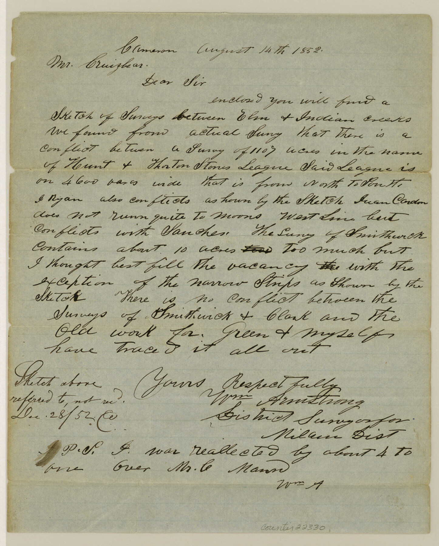
Falls County Sketch File 1
[Letter from surveyor referring to a sketch which was never sent]
-
Map/Doc
22330
-
Collection
General Map Collection
-
Object Dates
1852/8/14 (Creation Date)
-
People and Organizations
William Armstrong (Surveyor/Engineer)
-
Counties
Falls Bell
-
Subjects
Surveying Sketch File
-
Height x Width
10.7 x 8.6 inches
27.2 x 21.8 cm
-
Medium
paper, manuscript
-
Features
Elm Creek
Indian Creek
Part of: General Map Collection
Maverick County Sketch File 3

Print $40.00
- Digital $50.00
Maverick County Sketch File 3
Size 18.3 x 11.6 inches
Map/Doc 31033
Lavaca County Working Sketch 16

Print $20.00
- Digital $50.00
Lavaca County Working Sketch 16
1977
Size 25.0 x 24.9 inches
Map/Doc 70369
Travis County Appraisal District Plat Map 2_3215

Print $20.00
- Digital $50.00
Travis County Appraisal District Plat Map 2_3215
Size 21.5 x 26.4 inches
Map/Doc 94222
Polk County Sketch File 26a

Print $10.00
- Digital $50.00
Polk County Sketch File 26a
1878
Size 14.2 x 8.7 inches
Map/Doc 34189
Flight Mission No. BRE-2P, Frame 67, Nueces County

Print $20.00
- Digital $50.00
Flight Mission No. BRE-2P, Frame 67, Nueces County
1956
Size 18.5 x 22.3 inches
Map/Doc 86762
Maps of Gulf Intracoastal Waterway, Texas - Sabine River to the Rio Grande and connecting waterways including ship channels

Print $20.00
- Digital $50.00
Maps of Gulf Intracoastal Waterway, Texas - Sabine River to the Rio Grande and connecting waterways including ship channels
1966
Size 14.6 x 22.2 inches
Map/Doc 61980
Kendall County Sketch File 23

Print $40.00
- Digital $50.00
Kendall County Sketch File 23
1938
Size 15.5 x 15.9 inches
Map/Doc 28716
Young County Boundary File 2

Print $6.00
- Digital $50.00
Young County Boundary File 2
Size 14.2 x 8.7 inches
Map/Doc 60202
Corpus Christi Pass, Texas

Print $3.00
- Digital $50.00
Corpus Christi Pass, Texas
1869
Size 16.7 x 11.2 inches
Map/Doc 73456
Current Miscellaneous File 98

Print $40.00
- Digital $50.00
Current Miscellaneous File 98
Size 18.4 x 26.3 inches
Map/Doc 74338
Fisher County Working Sketch 4

Print $20.00
- Digital $50.00
Fisher County Working Sketch 4
1926
Size 24.4 x 17.2 inches
Map/Doc 69138
Georgetown and the City of Washington the Capital of the United States of America

Print $20.00
- Digital $50.00
Georgetown and the City of Washington the Capital of the United States of America
1856
Size 15.7 x 18.7 inches
Map/Doc 95359
You may also like
Wilbarger County Aerial Photograph Index Sheet 2

Print $20.00
- Digital $50.00
Wilbarger County Aerial Photograph Index Sheet 2
1950
Size 22.4 x 17.5 inches
Map/Doc 83751
Stephens County Sketch File 6a

Print $4.00
- Digital $50.00
Stephens County Sketch File 6a
Size 12.4 x 8.4 inches
Map/Doc 37023
Irion County Working Sketch 17

Print $20.00
- Digital $50.00
Irion County Working Sketch 17
1983
Size 37.4 x 41.6 inches
Map/Doc 66426
Archer County Sketch File 24

Print $40.00
- Digital $50.00
Archer County Sketch File 24
1924
Size 31.7 x 25.0 inches
Map/Doc 10832
[Surveys along the Frio River at the confluence of the Sabinal River]
![78372, [Surveys along the Frio River at the confluence of the Sabinal River], General Map Collection](https://historictexasmaps.com/wmedia_w700/maps/78372.tif.jpg)
Print $2.00
- Digital $50.00
[Surveys along the Frio River at the confluence of the Sabinal River]
1845
Size 6.2 x 8.9 inches
Map/Doc 78372
K&E Leroy Lettering Set - 3240

K&E Leroy Lettering Set - 3240
1944
Size 1.8 x 15.5 inches
Map/Doc 97314
City of Slaton, Lubbock County, Texas

Print $40.00
- Digital $50.00
City of Slaton, Lubbock County, Texas
Size 51.4 x 41.3 inches
Map/Doc 89897
Crockett County Rolled Sketch 73

Print $20.00
- Digital $50.00
Crockett County Rolled Sketch 73
1949
Size 10.4 x 23.6 inches
Map/Doc 5614
Houston County Sketch File 6a

Print $4.00
- Digital $50.00
Houston County Sketch File 6a
Size 10.2 x 8.1 inches
Map/Doc 26762
Webb County Rolled Sketch 73

Print $20.00
- Digital $50.00
Webb County Rolled Sketch 73
1982
Size 33.2 x 17.2 inches
Map/Doc 8221
In the Supreme Court of the United States, The State of Oklahoma, Complainant vs. The State of Texas, Defendant, The United States of America, Intervener, Red River Valley, Texas and Oklahoma Between the 98th and 100th Meridians in Five Sheets, 1921

Print $40.00
- Digital $50.00
In the Supreme Court of the United States, The State of Oklahoma, Complainant vs. The State of Texas, Defendant, The United States of America, Intervener, Red River Valley, Texas and Oklahoma Between the 98th and 100th Meridians in Five Sheets, 1921
1921
Size 37.7 x 60.2 inches
Map/Doc 75277
Map of Survey made for Bascom Giles, General Land Commissioner, covering Bob Reid Mineral Application No. 35521

Print $20.00
- Digital $50.00
Map of Survey made for Bascom Giles, General Land Commissioner, covering Bob Reid Mineral Application No. 35521
1941
Size 26.5 x 19.1 inches
Map/Doc 91964