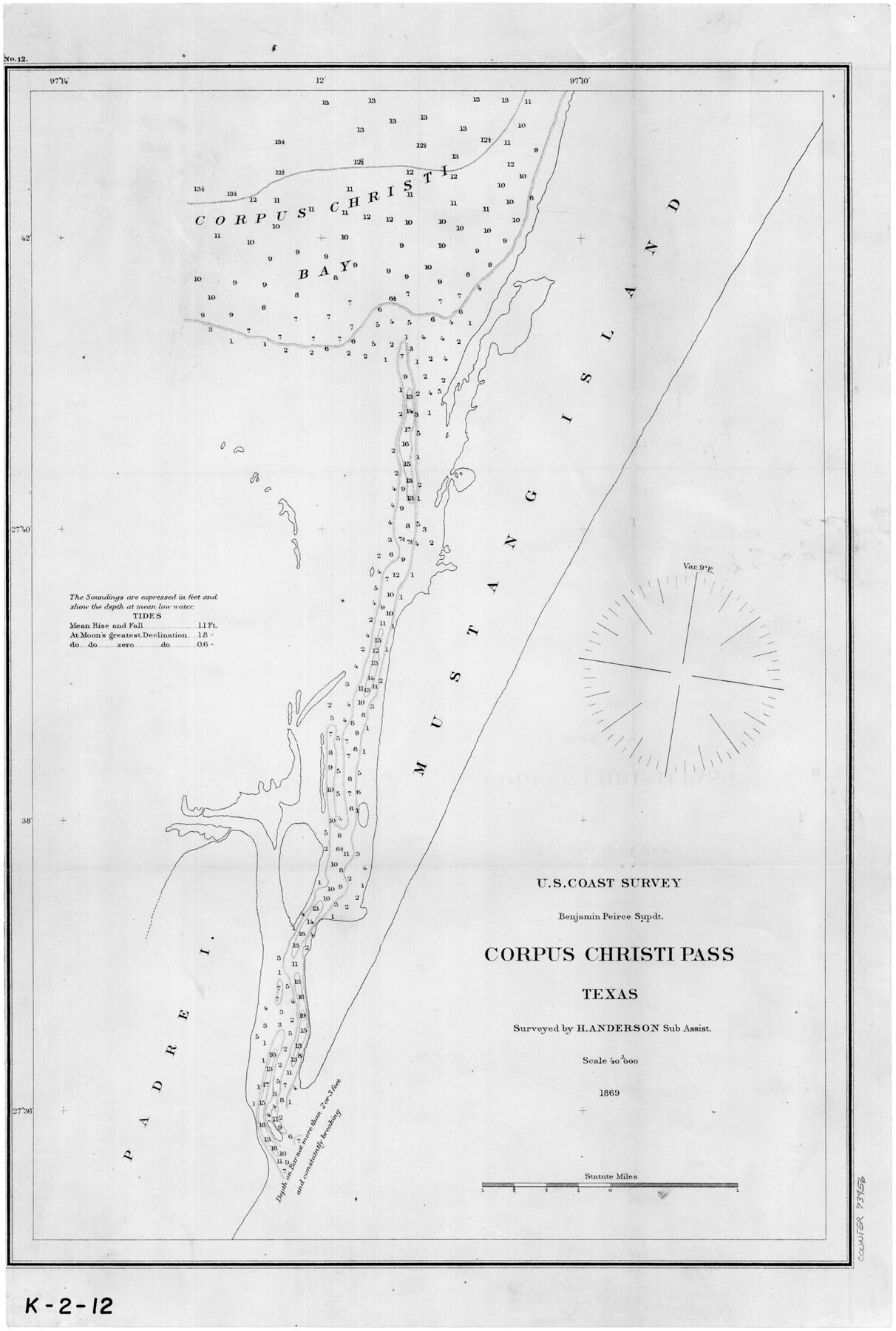
Corpus Christi Pass, Texas
K-2-12
-
Map/Doc
73456
-
Collection
General Map Collection
-
Object Dates
1869 (Creation Date)
-
Counties
Nueces
-
Subjects
Nautical Charts
-
Height x Width
16.7 x 11.2 inches
42.4 x 28.5 cm
Part of: General Map Collection
Flight Mission No. BQY-4M, Frame 44, Harris County

Print $20.00
- Digital $50.00
Flight Mission No. BQY-4M, Frame 44, Harris County
1953
Size 18.5 x 22.4 inches
Map/Doc 85259
Navarro County Rolled Sketch 7

Print $20.00
- Digital $50.00
Navarro County Rolled Sketch 7
Size 45.0 x 34.6 inches
Map/Doc 10308
Jack County Boundary File 3b

Print $23.00
- Digital $50.00
Jack County Boundary File 3b
Size 15.6 x 38.4 inches
Map/Doc 55418
Menard County Boundary File 1

Print $14.00
- Digital $50.00
Menard County Boundary File 1
Size 12.7 x 8.1 inches
Map/Doc 57035
Map of Burnet County

Print $20.00
- Digital $50.00
Map of Burnet County
1876
Size 24.5 x 21.3 inches
Map/Doc 3352
[Surveys along the Colorado River]
![112, [Surveys along the Colorado River], General Map Collection](https://historictexasmaps.com/wmedia_w700/maps/112.tif.jpg)
Print $2.00
- Digital $50.00
[Surveys along the Colorado River]
1841
Size 12.2 x 8.3 inches
Map/Doc 112
Hays County Rolled Sketch 31

Print $20.00
- Digital $50.00
Hays County Rolled Sketch 31
2001
Size 24.0 x 34.7 inches
Map/Doc 76421
![94161, Austin and Vicinity [Verso], General Map Collection](https://historictexasmaps.com/wmedia_w700/maps/94161.tif.jpg)
Sutton County Boundary File 2a

Print $20.00
- Digital $50.00
Sutton County Boundary File 2a
Size 8.6 x 6.3 inches
Map/Doc 59014
Erath County Sketch File 12a

Print $4.00
- Digital $50.00
Erath County Sketch File 12a
1871
Size 12.7 x 8.2 inches
Map/Doc 22283
Map of San Patricio County

Print $20.00
- Digital $50.00
Map of San Patricio County
1883
Size 17.2 x 26.8 inches
Map/Doc 4017
J No. 5 - Reconnaissance of San Clemente Harbor, California / Reconnaissance of Prisoner's Harbor, California / Reconnaissance of Cuyler's Harbor, Island of San Miguel, California

Print $20.00
- Digital $50.00
J No. 5 - Reconnaissance of San Clemente Harbor, California / Reconnaissance of Prisoner's Harbor, California / Reconnaissance of Cuyler's Harbor, Island of San Miguel, California
1852
Size 19.2 x 16.5 inches
Map/Doc 97234
You may also like
Fort Bend County State Real Property Sketch 3

Print $40.00
- Digital $50.00
Fort Bend County State Real Property Sketch 3
1986
Size 34.5 x 43.6 inches
Map/Doc 61677
Flight Mission No. DIX-7P, Frame 20, Aransas County

Print $20.00
- Digital $50.00
Flight Mission No. DIX-7P, Frame 20, Aransas County
1956
Size 18.8 x 22.5 inches
Map/Doc 83872
Dawson County Rolled Sketch 9

Print $20.00
- Digital $50.00
Dawson County Rolled Sketch 9
1953
Size 36.6 x 45.7 inches
Map/Doc 8773
Jack County Sketch File 3

Print $6.00
- Digital $50.00
Jack County Sketch File 3
1857
Size 10.6 x 16.5 inches
Map/Doc 27504
[Blk. B, Secs. 111-114 and vicinity]
![90340, [Blk. B, Secs. 111-114 and vicinity], Twichell Survey Records](https://historictexasmaps.com/wmedia_w700/maps/90340-1.tif.jpg)
Print $20.00
- Digital $50.00
[Blk. B, Secs. 111-114 and vicinity]
Size 31.3 x 38.7 inches
Map/Doc 90340
Angelina County Working Sketch 22b

Print $20.00
- Digital $50.00
Angelina County Working Sketch 22b
1953
Size 21.5 x 19.6 inches
Map/Doc 67104
[Surveys in Henderson County, Nacogdoches/Houston District]
![69735, [Surveys in Henderson County, Nacogdoches/Houston District], General Map Collection](https://historictexasmaps.com/wmedia_w700/maps/69735.tif.jpg)
Print $2.00
- Digital $50.00
[Surveys in Henderson County, Nacogdoches/Houston District]
Size 11.0 x 7.9 inches
Map/Doc 69735
Cameron County Sketch File 11

Print $58.00
- Digital $50.00
Cameron County Sketch File 11
1991
Size 11.0 x 7.9 inches
Map/Doc 17207
Winkler County Working Sketch 15

Print $20.00
- Digital $50.00
Winkler County Working Sketch 15
1964
Size 29.2 x 30.5 inches
Map/Doc 72609
Flight Mission No. DQN-1K, Frame 49, Calhoun County

Print $20.00
- Digital $50.00
Flight Mission No. DQN-1K, Frame 49, Calhoun County
1953
Size 18.6 x 22.4 inches
Map/Doc 84149
Brazoria County Rolled Sketch 30

Print $20.00
- Digital $50.00
Brazoria County Rolled Sketch 30
1940
Size 17.8 x 22.9 inches
Map/Doc 5168
[Bastrop District]
![83518, [Bastrop District], General Map Collection](https://historictexasmaps.com/wmedia_w700/maps/83518-1.tif.jpg)
Print $20.00
- Digital $50.00
[Bastrop District]
1838
Size 19.5 x 44.2 inches
Map/Doc 83518