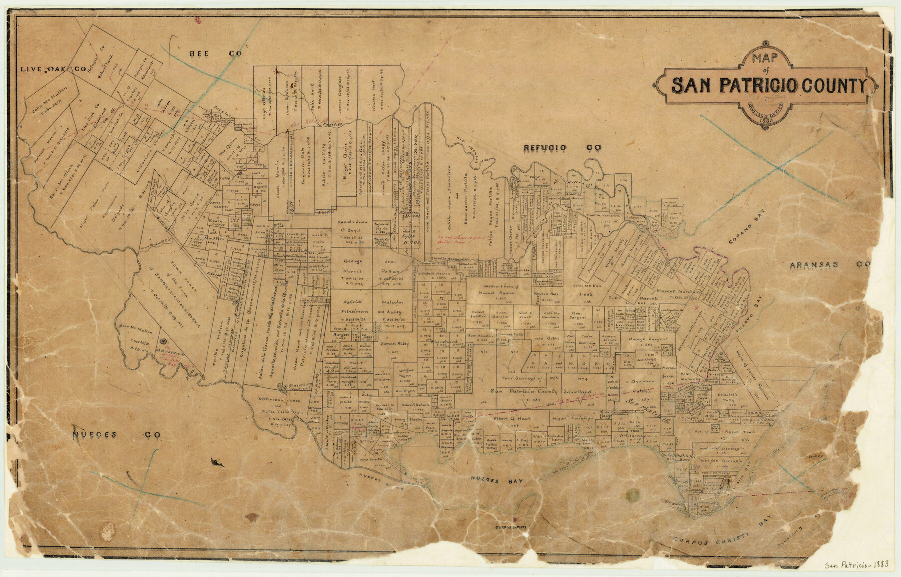
Map of San Patricio County
-
Map/Doc
4017
-
Collection
General Map Collection
-
Object Dates
1883 (Creation Date)
-
People and Organizations
Texas General Land Office (Publisher)
-
Counties
San Patricio
-
Subjects
County
-
Height x Width
17.2 x 26.8 inches
43.7 x 68.1 cm
-
Features
Rio Aransas
Papelote Creek
Copano Bay
Chilipin [sic] Creek
Aroyo [sic] Nombre de Dios
Puerto Bay
San Patricio
Sharpsburg
Mary Lee Island
Nueces River
Corpus Christi
Nueces Bay
Ingleside
Red Fish Bay
Mustang Island
Corpus Christi Bay
Part of: General Map Collection
Uvalde County Working Sketch 23

Print $20.00
- Digital $50.00
Uvalde County Working Sketch 23
1952
Size 32.0 x 26.6 inches
Map/Doc 72093
Panola County Rolled Sketch 1

Print $20.00
- Digital $50.00
Panola County Rolled Sketch 1
Size 17.5 x 23.9 inches
Map/Doc 7196
Real County Rolled Sketch 18

Print $20.00
- Digital $50.00
Real County Rolled Sketch 18
Size 22.0 x 28.0 inches
Map/Doc 7466
Flight Mission No. CGI-3N, Frame 123, Cameron County

Print $20.00
- Digital $50.00
Flight Mission No. CGI-3N, Frame 123, Cameron County
1954
Size 18.6 x 22.2 inches
Map/Doc 84596
McMullen County Working Sketch 14

Print $20.00
- Digital $50.00
McMullen County Working Sketch 14
1938
Size 28.6 x 37.1 inches
Map/Doc 70715
Zavala County Sketch File 46

Print $20.00
- Digital $50.00
Zavala County Sketch File 46
1937
Size 16.7 x 18.8 inches
Map/Doc 12734
Madison County Working Sketch 7

Print $20.00
- Digital $50.00
Madison County Working Sketch 7
1982
Size 12.7 x 17.4 inches
Map/Doc 70769
Zapata County Rolled Sketch 14

Print $20.00
- Digital $50.00
Zapata County Rolled Sketch 14
1925
Size 19.2 x 43.7 inches
Map/Doc 10168
Flight Mission No. BRE-1P, Frame 46, Nueces County

Print $20.00
- Digital $50.00
Flight Mission No. BRE-1P, Frame 46, Nueces County
1956
Size 16.4 x 16.2 inches
Map/Doc 86635
Flight Mission No. CRC-4R, Frame 107, Chambers County

Print $20.00
- Digital $50.00
Flight Mission No. CRC-4R, Frame 107, Chambers County
1956
Size 18.8 x 22.4 inches
Map/Doc 84904
Motley County Sketch File B4 (N)

Print $20.00
- Digital $50.00
Motley County Sketch File B4 (N)
1900
Size 23.5 x 25.8 inches
Map/Doc 42151
Wichita County Working Sketch 17

Print $20.00
- Digital $50.00
Wichita County Working Sketch 17
1940
Size 25.6 x 26.1 inches
Map/Doc 72527
You may also like
Cameron County State Real Property Sketch 1

Print $20.00
- Digital $50.00
Cameron County State Real Property Sketch 1
1996
Size 25.1 x 38.9 inches
Map/Doc 80130
Hudspeth County Sketch File 11a

Print $8.00
- Digital $50.00
Hudspeth County Sketch File 11a
Size 14.3 x 9.0 inches
Map/Doc 26910
Borden and Garza County Boundary Line Plat

Print $2.00
- Digital $50.00
Borden and Garza County Boundary Line Plat
1965
Size 14.2 x 8.8 inches
Map/Doc 61152
[Blocks M-23, M-17, M-18, H, G, and vicinity]
![91140, [Blocks M-23, M-17, M-18, H, G, and vicinity], Twichell Survey Records](https://historictexasmaps.com/wmedia_w700/maps/91140-1.tif.jpg)
Print $20.00
- Digital $50.00
[Blocks M-23, M-17, M-18, H, G, and vicinity]
1882
Size 12.6 x 12.2 inches
Map/Doc 91140
Montgomery County Working Sketch 59

Print $20.00
- Digital $50.00
Montgomery County Working Sketch 59
1962
Size 25.4 x 22.8 inches
Map/Doc 71166
Culberson County Sketch File 43

Print $4.00
- Digital $50.00
Culberson County Sketch File 43
1931
Size 8.9 x 11.1 inches
Map/Doc 20329
La Salle County Sketch File 28

Print $6.00
- Digital $50.00
La Salle County Sketch File 28
1882
Size 8.7 x 3.6 inches
Map/Doc 29555
Harris County Rolled Sketch 82
Print $40.00
- Digital $50.00
Harris County Rolled Sketch 82
1956
Size 50.5 x 36.4 inches
Map/Doc 9138
Orange County Working Sketch 41

Print $20.00
- Digital $50.00
Orange County Working Sketch 41
1979
Size 28.0 x 18.2 inches
Map/Doc 71373
Robertson County Working Sketch 5

Print $20.00
- Digital $50.00
Robertson County Working Sketch 5
1980
Size 33.9 x 44.1 inches
Map/Doc 63578
Flight Mission No. DAH-9M, Frame 159, Orange County

Print $20.00
- Digital $50.00
Flight Mission No. DAH-9M, Frame 159, Orange County
1953
Size 18.6 x 22.5 inches
Map/Doc 86858
Montague County Working Sketch 32

Print $20.00
- Digital $50.00
Montague County Working Sketch 32
1975
Size 26.0 x 26.1 inches
Map/Doc 71098