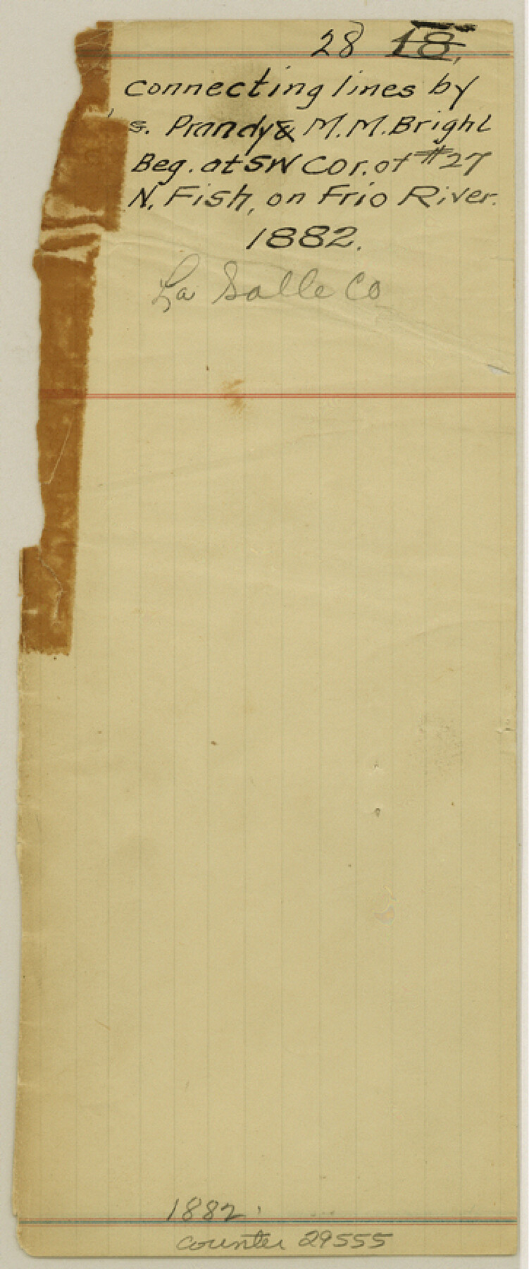
La Salle County Sketch File 28
[Connecting line beginning at southwest corner of no. 27 on Frio River]
-
Map/Doc
29555
-
Collection
General Map Collection
-
Object Dates
1882 (Creation Date)
-
People and Organizations
Thomas Prandy (Surveyor/Engineer)
-
Counties
La Salle McMullen
-
Subjects
Surveying Sketch File
-
Height x Width
8.7 x 3.6 inches
22.1 x 9.1 cm
-
Medium
paper, manuscript
-
Features
Frio River
Old Guado Road
Part of: General Map Collection
Galveston Bay Texas Lower Part Encluding [sic] Bar and Entrance
![69869, Galveston Bay Texas Lower Part Encluding [sic] Bar and Entrance, General Map Collection](https://historictexasmaps.com/wmedia_w700/maps/69869-1.tif.jpg)
Print $40.00
- Digital $50.00
Galveston Bay Texas Lower Part Encluding [sic] Bar and Entrance
1867
Size 52.6 x 39.1 inches
Map/Doc 69869
Montgomery County Sketch File 16

Print $26.00
- Digital $50.00
Montgomery County Sketch File 16
1896
Size 14.2 x 8.8 inches
Map/Doc 31819

Controlled Mosaic by Jack Amman Photogrammetric Engineers, Inc - Sheet 55

Print $20.00
- Digital $50.00
Controlled Mosaic by Jack Amman Photogrammetric Engineers, Inc - Sheet 55
1954
Size 20.0 x 24.0 inches
Map/Doc 83514
Angelina County Working Sketch 53

Print $40.00
- Digital $50.00
Angelina County Working Sketch 53
1988
Size 42.9 x 58.5 inches
Map/Doc 67137
Edwards County Rolled Sketch JF

Print $20.00
- Digital $50.00
Edwards County Rolled Sketch JF
1915
Size 25.2 x 30.5 inches
Map/Doc 5819
Gaines County

Print $40.00
- Digital $50.00
Gaines County
1956
Size 43.8 x 55.0 inches
Map/Doc 73154
Webb County Rolled Sketch 71

Print $20.00
- Digital $50.00
Webb County Rolled Sketch 71
Size 24.2 x 18.5 inches
Map/Doc 8218
Hartley County Sketch File 17

Print $4.00
- Digital $50.00
Hartley County Sketch File 17
1892
Size 11.2 x 8.9 inches
Map/Doc 26115
Robertson County Sketch File 9

Print $68.00
Robertson County Sketch File 9
1846
Size 10.2 x 8.3 inches
Map/Doc 35366
Brown County Working Sketch 1

Print $20.00
- Digital $50.00
Brown County Working Sketch 1
1918
Size 20.3 x 29.0 inches
Map/Doc 67766
Bowie County Sketch File 6b

Print $40.00
- Digital $50.00
Bowie County Sketch File 6b
Size 14.4 x 13.5 inches
Map/Doc 14848
You may also like
Oldham County Rolled Sketch T

Print $20.00
- Digital $50.00
Oldham County Rolled Sketch T
1903
Size 42.3 x 46.2 inches
Map/Doc 9642
Burleson County Sketch File 3

Print $4.00
- Digital $50.00
Burleson County Sketch File 3
1848
Size 6.4 x 7.4 inches
Map/Doc 16647
Wood County Working Sketch 15

Print $20.00
- Digital $50.00
Wood County Working Sketch 15
1981
Size 25.7 x 31.7 inches
Map/Doc 62015
Flight Mission No. CLL-1N, Frame 198, Willacy County

Print $20.00
- Digital $50.00
Flight Mission No. CLL-1N, Frame 198, Willacy County
1954
Size 18.4 x 22.1 inches
Map/Doc 87068
Jefferson County Sketch File 45

Print $20.00
- Digital $50.00
Jefferson County Sketch File 45
1933
Size 16.7 x 33.0 inches
Map/Doc 11879
Carden L. Green Farm Part Sections 13 & 22, Block JS

Print $20.00
- Digital $50.00
Carden L. Green Farm Part Sections 13 & 22, Block JS
Size 14.0 x 24.1 inches
Map/Doc 92324
Armstrong County Sketch File 2

Print $40.00
- Digital $50.00
Armstrong County Sketch File 2
Size 21.5 x 40.0 inches
Map/Doc 10371
Site Development Study for the D. M. Cogdell Memorial Hospital Snyder, Texas

Print $20.00
- Digital $50.00
Site Development Study for the D. M. Cogdell Memorial Hospital Snyder, Texas
Size 24.1 x 26.8 inches
Map/Doc 92922
Galveston County Rolled Sketch 44

Print $2.00
- Digital $50.00
Galveston County Rolled Sketch 44
Size 17.6 x 11.3 inches
Map/Doc 5976
Pecos County Rolled Sketch 97

Print $20.00
- Digital $50.00
Pecos County Rolled Sketch 97
Size 24.7 x 36.8 inches
Map/Doc 7248
Map of the country adjacent to the left bank of the Rio Grande below Matamoros

Print $20.00
- Digital $50.00
Map of the country adjacent to the left bank of the Rio Grande below Matamoros
1847
Size 18.3 x 27.3 inches
Map/Doc 72868
La Salle County Sketch File 30

Print $22.00
- Digital $50.00
La Salle County Sketch File 30
1880
Size 12.6 x 8.2 inches
Map/Doc 29565