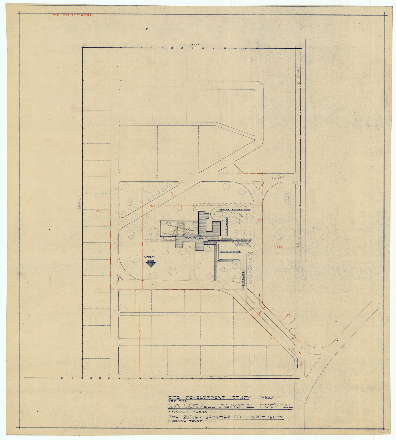
Site Development Study for the D. M. Cogdell Memorial Hospital Snyder, Texas
-
Map/Doc
92922
-
Collection
Twichell Survey Records
-
People and Organizations
The Butler-Brasher Co. (Compiler)
-
Counties
Scurry
-
Height x Width
24.1 x 26.8 inches
61.2 x 68.1 cm
Part of: Twichell Survey Records
Sheet 3 copied from Champlin Book 5 [Strip Map showing T. & P. connecting lines]
![93179, Sheet 3 copied from Champlin Book 5 [Strip Map showing T. & P. connecting lines], Twichell Survey Records](https://historictexasmaps.com/wmedia_w700/maps/93179-1.tif.jpg)
Print $40.00
- Digital $50.00
Sheet 3 copied from Champlin Book 5 [Strip Map showing T. & P. connecting lines]
1909
Size 7.5 x 74.8 inches
Map/Doc 93179
[In Northwest 1/4 of County in the vicinity of the John Walker Survey]
![90910, [In Northwest 1/4 of County in the vicinity of the John Walker Survey], Twichell Survey Records](https://historictexasmaps.com/wmedia_w700/maps/90910-1.tif.jpg)
Print $20.00
- Digital $50.00
[In Northwest 1/4 of County in the vicinity of the John Walker Survey]
Size 15.2 x 23.9 inches
Map/Doc 90910
[Littlefield Subdivision Blocks 657-687]
![91008, [Littlefield Subdivision Blocks 657-687], Twichell Survey Records](https://historictexasmaps.com/wmedia_w700/maps/91008-1.tif.jpg)
Print $20.00
- Digital $50.00
[Littlefield Subdivision Blocks 657-687]
Size 15.7 x 12.1 inches
Map/Doc 91008

City of Lubbock, Lubbock County, Texas

Print $40.00
- Digital $50.00
City of Lubbock, Lubbock County, Texas
1946
Size 54.3 x 39.1 inches
Map/Doc 89902

[T. & P. RR. Lands and Surrounding surveys]
![91131, [T. & P. RR. Lands and Surrounding surveys], Twichell Survey Records](https://historictexasmaps.com/wmedia_w700/maps/91131.tif.jpg)
Print $20.00
- Digital $50.00
[T. & P. RR. Lands and Surrounding surveys]
1900
Size 16.4 x 12.2 inches
Map/Doc 91131

[John P. Rohus and surrounding surveys]
![90974, [John P. Rohus and surrounding surveys], Twichell Survey Records](https://historictexasmaps.com/wmedia_w700/maps/90974-1.tif.jpg)
Print $20.00
- Digital $50.00
[John P. Rohus and surrounding surveys]
Size 26.1 x 19.9 inches
Map/Doc 90974
[Sketch highlighting Bob Reid and Fred Turner surveys]
![91693, [Sketch highlighting Bob Reid and Fred Turner surveys], Twichell Survey Records](https://historictexasmaps.com/wmedia_w700/maps/91693-1.tif.jpg)
Print $20.00
- Digital $50.00
[Sketch highlighting Bob Reid and Fred Turner surveys]
Size 12.5 x 17.8 inches
Map/Doc 91693
[Sketch Showing South part of Capitol Lands]
![93086, [Sketch Showing South part of Capitol Lands], Twichell Survey Records](https://historictexasmaps.com/wmedia_w700/maps/93086-1.tif.jpg)
Print $20.00
- Digital $50.00
[Sketch Showing South part of Capitol Lands]
Size 47.3 x 17.7 inches
Map/Doc 93086
[Blocks C4, S1, K and C3 in Northern Hale/Southern Swisher Counties]
![91858, [Blocks C4, S1, K and C3 in Northern Hale/Southern Swisher Counties], Twichell Survey Records](https://historictexasmaps.com/wmedia_w700/maps/91858-1.tif.jpg)
Print $2.00
- Digital $50.00
[Blocks C4, S1, K and C3 in Northern Hale/Southern Swisher Counties]
1906
Size 15.0 x 8.7 inches
Map/Doc 91858
You may also like
Pecos County Rolled Sketch 116

Print $20.00
- Digital $50.00
Pecos County Rolled Sketch 116
Size 26.7 x 20.6 inches
Map/Doc 7259
Martin County Working Sketch 16

Print $20.00
- Digital $50.00
Martin County Working Sketch 16
1979
Size 26.6 x 36.8 inches
Map/Doc 70834
Flight Mission No. CRC-3R, Frame 39, Chambers County

Print $20.00
- Digital $50.00
Flight Mission No. CRC-3R, Frame 39, Chambers County
1956
Size 18.6 x 22.4 inches
Map/Doc 84812
Archer County Boundary File 3

Print $54.00
- Digital $50.00
Archer County Boundary File 3
Size 9.3 x 7.3 inches
Map/Doc 50094
[Sketch showing H. & G. N. Block A on the north side of the Canadian River and H. & T. C. Block 46 on the south side of the Canadian River]
![91763, [Sketch showing H. & G. N. Block A on the north side of the Canadian River and H. & T. C. Block 46 on the south side of the Canadian River], Twichell Survey Records](https://historictexasmaps.com/wmedia_w700/maps/91763-1.tif.jpg)
Print $20.00
- Digital $50.00
[Sketch showing H. & G. N. Block A on the north side of the Canadian River and H. & T. C. Block 46 on the south side of the Canadian River]
1927
Size 25.1 x 11.2 inches
Map/Doc 91763
Mason County Sketch File 5

Print $20.00
- Digital $50.00
Mason County Sketch File 5
1875
Size 15.8 x 12.9 inches
Map/Doc 12033
Uvalde County Working Sketch 59

Print $20.00
- Digital $50.00
Uvalde County Working Sketch 59
1989
Size 25.1 x 39.1 inches
Map/Doc 72129
Irion County Rolled Sketch 18A

Print $20.00
- Digital $50.00
Irion County Rolled Sketch 18A
Size 45.5 x 29.8 inches
Map/Doc 6327
Flight Mission No. DQO-2K, Frame 83, Galveston County

Print $20.00
- Digital $50.00
Flight Mission No. DQO-2K, Frame 83, Galveston County
1952
Size 18.8 x 22.5 inches
Map/Doc 85010
Working Sketch in Eastland, Stephens, and Palo Pinto Cos.

Print $20.00
- Digital $50.00
Working Sketch in Eastland, Stephens, and Palo Pinto Cos.
Size 18.0 x 15.1 inches
Map/Doc 91975
Harrison County Rolled Sketch 12

Print $20.00
- Digital $50.00
Harrison County Rolled Sketch 12
1960
Size 22.9 x 34.9 inches
Map/Doc 6155
Culberson County Working Sketch 69

Print $40.00
- Digital $50.00
Culberson County Working Sketch 69
1975
Size 49.4 x 32.2 inches
Map/Doc 68523