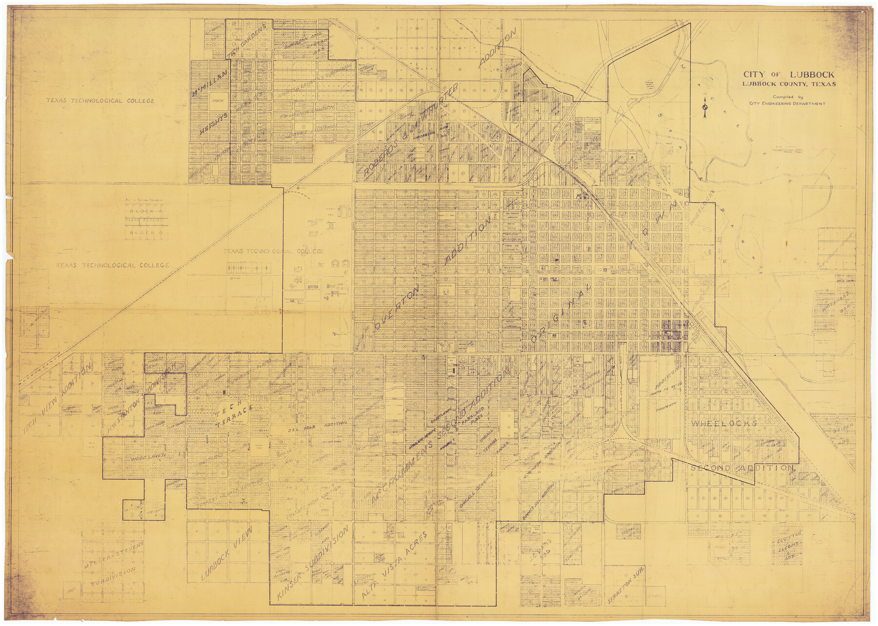
City of Lubbock, Lubbock County, Texas
-
Map/Doc
89902
-
Collection
Twichell Survey Records
-
Object Dates
3/1946 (Creation Date)
-
People and Organizations
City Engineering Department (Compiler)
-
Counties
Lubbock
-
Subjects
City
-
Height x Width
54.3 x 39.1 inches
137.9 x 99.3 cm
Part of: Twichell Survey Records
Sketch in Hockley County

Print $20.00
- Digital $50.00
Sketch in Hockley County
1911
Size 7.1 x 20.5 inches
Map/Doc 91123
[R. T. Bucy's Survey 3, League 321]
![91296, [R. T. Bucy's Survey 3, League 321], Twichell Survey Records](https://historictexasmaps.com/wmedia_w700/maps/91296-1.tif.jpg)
Print $20.00
- Digital $50.00
[R. T. Bucy's Survey 3, League 321]
Size 12.2 x 19.1 inches
Map/Doc 91296
[Blocks GG, 1, 29, A2, Archer County School Land Sections 1,2,3,4]
![92439, [Blocks GG, 1, 29, A2, Archer County School Land Sections 1,2,3,4], Twichell Survey Records](https://historictexasmaps.com/wmedia_w700/maps/92439-1.tif.jpg)
Print $20.00
- Digital $50.00
[Blocks GG, 1, 29, A2, Archer County School Land Sections 1,2,3,4]
Size 26.7 x 19.0 inches
Map/Doc 92439
[Pencil sketch of C. B., H. L. and Jno. Robertson and surrounding surveys]
![89981, [Pencil sketch of C. B., H. L. and Jno. Robertson and surrounding surveys], Twichell Survey Records](https://historictexasmaps.com/wmedia_w700/maps/89981-1.tif.jpg)
Print $20.00
- Digital $50.00
[Pencil sketch of C. B., H. L. and Jno. Robertson and surrounding surveys]
Size 21.1 x 9.8 inches
Map/Doc 89981
Crane County Map of Unsurveyed School Lands for Bob Reid's Application to Lease

Print $40.00
- Digital $50.00
Crane County Map of Unsurveyed School Lands for Bob Reid's Application to Lease
1946
Size 49.0 x 51.3 inches
Map/Doc 90466
Post City and Surroundings Showing Improvements and 4 Sec. Pastures

Print $20.00
- Digital $50.00
Post City and Surroundings Showing Improvements and 4 Sec. Pastures
1911
Size 36.4 x 29.8 inches
Map/Doc 90858
[Sketch showing G. & M. Block M-20, Sections 29-46]
![91706, [Sketch showing G. & M. Block M-20, Sections 29-46], Twichell Survey Records](https://historictexasmaps.com/wmedia_w700/maps/91706-1.tif.jpg)
Print $2.00
- Digital $50.00
[Sketch showing G. & M. Block M-20, Sections 29-46]
Size 6.7 x 13.4 inches
Map/Doc 91706
Sketch of Part of Moore County

Print $20.00
- Digital $50.00
Sketch of Part of Moore County
1912
Size 30.1 x 33.6 inches
Map/Doc 92293
[Block B&, and Adjacent Leagues]
![91432, [Block B&, and Adjacent Leagues], Twichell Survey Records](https://historictexasmaps.com/wmedia_w700/maps/91432-1.tif.jpg)
Print $20.00
- Digital $50.00
[Block B&, and Adjacent Leagues]
Size 30.7 x 29.6 inches
Map/Doc 91432
[T. & P. Blocks 43-44, Townships 1S, 2S and 1N]
![90830, [T. & P. Blocks 43-44, Townships 1S, 2S and 1N], Twichell Survey Records](https://historictexasmaps.com/wmedia_w700/maps/90830-2.tif.jpg)
Print $20.00
- Digital $50.00
[T. & P. Blocks 43-44, Townships 1S, 2S and 1N]
Size 18.8 x 22.6 inches
Map/Doc 90830
[Lamb County, Block A]
![90991, [Lamb County, Block A], Twichell Survey Records](https://historictexasmaps.com/wmedia_w700/maps/90991-1.tif.jpg)
Print $20.00
- Digital $50.00
[Lamb County, Block A]
Size 22.9 x 17.9 inches
Map/Doc 90991
Sketch of Resurvey, Township 5 North. Block 36. Texas and Pacific Railroad Company, Dawson County

Print $20.00
- Digital $50.00
Sketch of Resurvey, Township 5 North. Block 36. Texas and Pacific Railroad Company, Dawson County
1926
Size 24.6 x 25.0 inches
Map/Doc 92572
You may also like
Southern Part of Laguna Madre

Print $20.00
- Digital $50.00
Southern Part of Laguna Madre
1972
Size 44.3 x 35.6 inches
Map/Doc 73542
Bexar County State Real Property Sketch 2

Print $40.00
- Digital $50.00
Bexar County State Real Property Sketch 2
1997
Size 25.6 x 38.7 inches
Map/Doc 61701
Bee County Working Sketch 8

Print $20.00
- Digital $50.00
Bee County Working Sketch 8
1939
Size 18.0 x 20.5 inches
Map/Doc 67258
Palo Pinto County Rolled Sketch 15

Print $20.00
- Digital $50.00
Palo Pinto County Rolled Sketch 15
Size 19.2 x 24.5 inches
Map/Doc 88734
Red River County Working Sketch 54

Print $20.00
- Digital $50.00
Red River County Working Sketch 54
1971
Size 19.3 x 31.1 inches
Map/Doc 72037
Texas Intracoastal Waterway - Stover Point to Port Brownsville including Brazos Santiago

Print $20.00
- Digital $50.00
Texas Intracoastal Waterway - Stover Point to Port Brownsville including Brazos Santiago
1965
Size 27.5 x 38.9 inches
Map/Doc 73521
Map Showing the Distribution of the Slave Population of the Southern States of the United States

Map Showing the Distribution of the Slave Population of the Southern States of the United States
2022
Size 8.5 x 11.0 inches
Map/Doc 96677
Flight Mission No. CGI-4N, Frame 190, Cameron County

Print $20.00
- Digital $50.00
Flight Mission No. CGI-4N, Frame 190, Cameron County
1955
Size 18.5 x 22.2 inches
Map/Doc 84693
Colorado County Working Sketch 13

Print $20.00
- Digital $50.00
Colorado County Working Sketch 13
1943
Size 37.9 x 23.3 inches
Map/Doc 68113
Reagan County Rolled Sketch 28

Print $40.00
- Digital $50.00
Reagan County Rolled Sketch 28
1952
Size 64.1 x 46.5 inches
Map/Doc 9823
Polk County Sketch File 13

Print $4.00
- Digital $50.00
Polk County Sketch File 13
Size 5.1 x 7.4 inches
Map/Doc 34150
Map of Blanco County

Print $20.00
- Digital $50.00
Map of Blanco County
1880
Size 23.9 x 18.2 inches
Map/Doc 3306