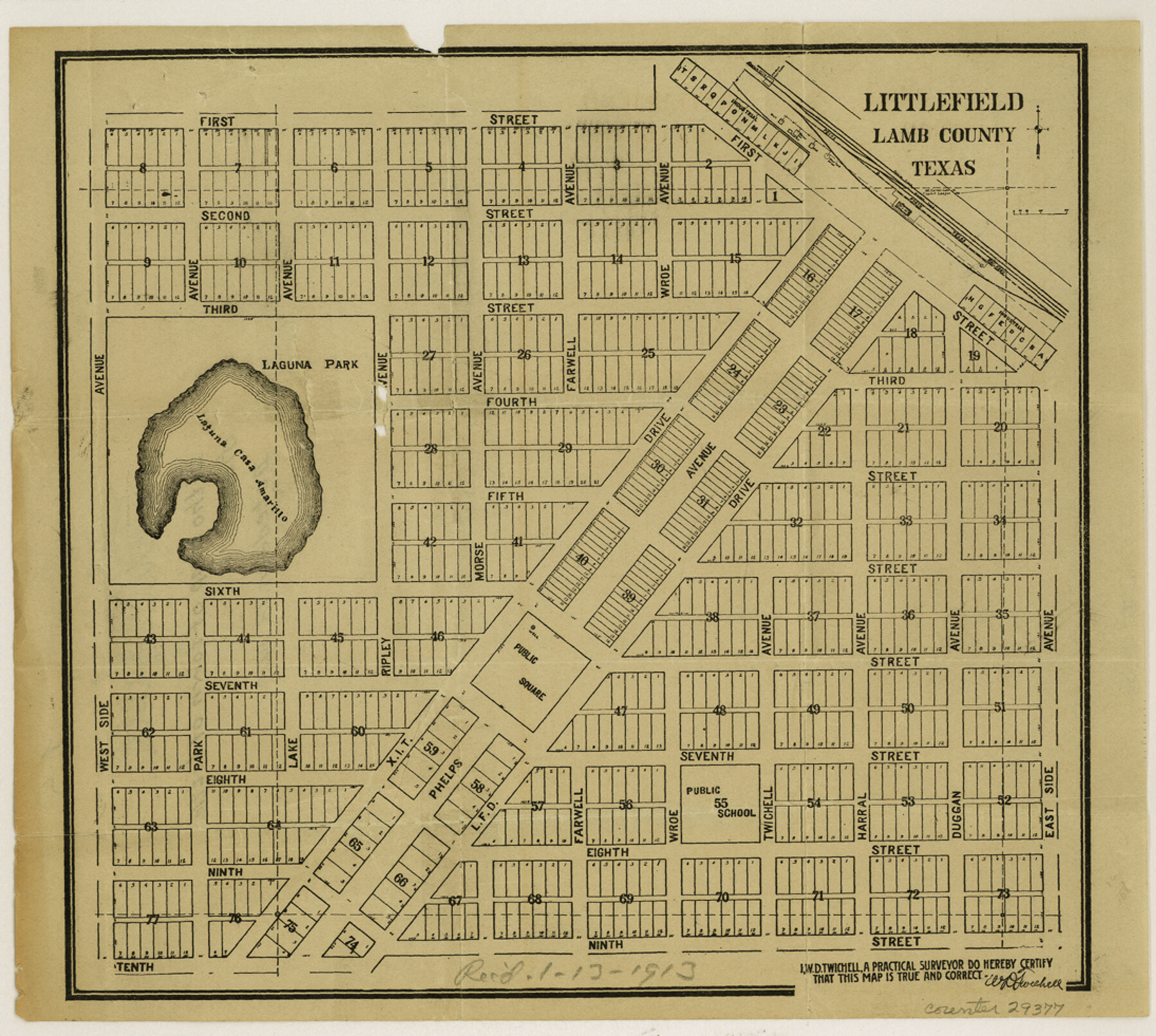
Lamb County Sketch File 15
Littlefield, Lamb County, Texas
-
Map/Doc
29377
-
Collection
General Map Collection
-
Object Dates
1/13/1913 (File Date)
-
People and Organizations
W.D. Twichell (Surveyor/Engineer)
-
Counties
Lamb
-
Subjects
Surveying Sketch File City
-
Height x Width
9.8 x 10.9 inches
24.9 x 27.7 cm
-
Medium
paper, etching/engraving/lithograph
-
Features
Farwell Avenue
Tenth Street
LFD Drive
XIT Drive
Ninth Street
Eighth Street
West Side Avenue
East Side Avenue
Duggan Avenue
Harral Avenue
Twichell Avenue
Seventh Street
First Street
Phelps Avenue
Ripley Avenue
Lake Avenue
Sixth Street
Laguna Park
Wroe Avenue
Morse Avenue
Fifth Street
Fourth Street
Third Street
Second Street
Part of: General Map Collection
Maverick County Sketch File 28

Print $4.00
- Digital $50.00
Maverick County Sketch File 28
1893
Size 11.0 x 8.9 inches
Map/Doc 31163
Montague County Working Sketch 17

Print $20.00
- Digital $50.00
Montague County Working Sketch 17
1947
Size 22.1 x 30.0 inches
Map/Doc 71083
Map of Palo Pinto County

Print $20.00
- Digital $50.00
Map of Palo Pinto County
1898
Size 45.8 x 37.6 inches
Map/Doc 16783
East Part of Edwards County

Print $40.00
- Digital $50.00
East Part of Edwards County
1975
Size 55.7 x 40.5 inches
Map/Doc 73138
Real County Rolled Sketch 6

Print $20.00
- Digital $50.00
Real County Rolled Sketch 6
Size 28.0 x 23.7 inches
Map/Doc 7456
[Surveys along Davidson's Creek]
![243, [Surveys along Davidson's Creek], General Map Collection](https://historictexasmaps.com/wmedia_w700/maps/243.tif.jpg)
Print $2.00
- Digital $50.00
[Surveys along Davidson's Creek]
Size 5.3 x 4.7 inches
Map/Doc 243
Rio Grande Rectification Project, El Paso and Juarez Valley

Print $2.00
- Digital $50.00
Rio Grande Rectification Project, El Paso and Juarez Valley
1935
Size 10.8 x 8.2 inches
Map/Doc 60873
Henderson County Rolled Sketch 11

Print $20.00
- Digital $50.00
Henderson County Rolled Sketch 11
1915
Size 28.9 x 42.6 inches
Map/Doc 76148
Culberson County Working Sketch 18

Print $20.00
- Digital $50.00
Culberson County Working Sketch 18
1928
Size 42.6 x 19.7 inches
Map/Doc 68470
Val Verde County Working Sketch 4

Print $20.00
- Digital $50.00
Val Verde County Working Sketch 4
1906
Size 23.9 x 17.3 inches
Map/Doc 72139

Angelina County Rolled Sketch 3

Print $20.00
- Digital $50.00
Angelina County Rolled Sketch 3
Size 25.9 x 42.5 inches
Map/Doc 77186
You may also like
Crockett County Working Sketch 53

Print $20.00
- Digital $50.00
Crockett County Working Sketch 53
1948
Size 24.2 x 27.7 inches
Map/Doc 68386
Presidio County Rolled Sketch 102

Print $20.00
- Digital $50.00
Presidio County Rolled Sketch 102
1957
Size 19.3 x 13.8 inches
Map/Doc 7385
[John S. Stephens Blk. S2, Lgs. 174-177, 186-193, 201-209]
![90104, [John S. Stephens Blk. S2, Lgs. 174-177, 186-193, 201-209], Twichell Survey Records](https://historictexasmaps.com/wmedia_w700/maps/90104-1.tif.jpg)
Print $2.00
- Digital $50.00
[John S. Stephens Blk. S2, Lgs. 174-177, 186-193, 201-209]
1912
Size 11.3 x 8.8 inches
Map/Doc 90104
Travis County Working Sketch 56

Print $20.00
- Digital $50.00
Travis County Working Sketch 56
1989
Size 19.7 x 20.4 inches
Map/Doc 69440
Baylor County Working Sketch 6

Print $20.00
- Digital $50.00
Baylor County Working Sketch 6
1943
Size 27.5 x 41.0 inches
Map/Doc 67291
Denton County Boundary File 2

Print $22.00
- Digital $50.00
Denton County Boundary File 2
Size 14.1 x 8.5 inches
Map/Doc 52413
Ward County Working Sketch 52

Print $20.00
- Digital $50.00
Ward County Working Sketch 52
1980
Size 36.3 x 37.0 inches
Map/Doc 72358
Webb County Rolled Sketch 14

Print $20.00
- Digital $50.00
Webb County Rolled Sketch 14
1915
Size 12.6 x 28.5 inches
Map/Doc 8178
Presidio County Rolled Sketch 102

Print $20.00
- Digital $50.00
Presidio County Rolled Sketch 102
1957
Size 22.8 x 17.4 inches
Map/Doc 7384
Sketch showing surveys on Harbor Island in Nueces County

Print $20.00
- Digital $50.00
Sketch showing surveys on Harbor Island in Nueces County
1978
Size 46.4 x 36.0 inches
Map/Doc 2020
[Coleman County Sections 359, 360, and 361]
![92553, [Coleman County Sections 359, 360, and 361], Twichell Survey Records](https://historictexasmaps.com/wmedia_w700/maps/92553-1.tif.jpg)
Print $20.00
- Digital $50.00
[Coleman County Sections 359, 360, and 361]
Size 17.6 x 22.5 inches
Map/Doc 92553
United States - Gulf Coast Texas - Northern part of Laguna Madre

Print $20.00
- Digital $50.00
United States - Gulf Coast Texas - Northern part of Laguna Madre
1941
Size 26.7 x 18.4 inches
Map/Doc 72933