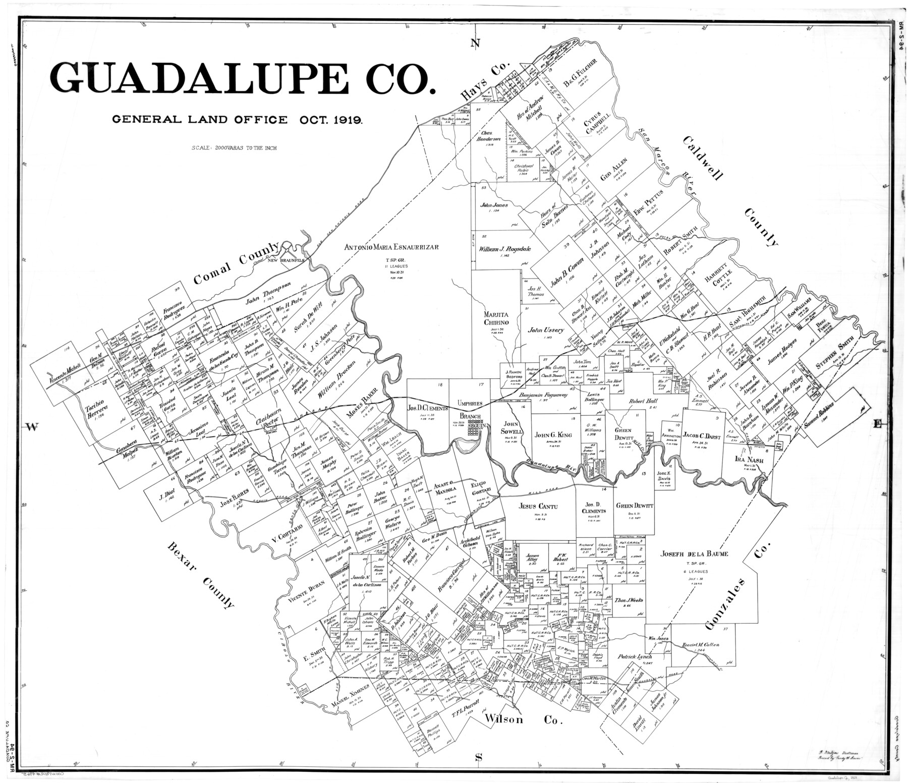
Guadalupe Co.
RM-2-94
-
Map/Doc
4965
-
Collection
General Map Collection
-
Object Dates
10/1919 (Creation Date)
-
People and Organizations
Texas General Land Office (Publisher)
Fr. Matzow (Draftsman)
Fr. Matzow (Compiler)
-
Counties
Guadalupe
-
Subjects
County
-
Height x Width
39.6 x 44.7 inches
100.6 x 113.5 cm
-
Comments
Traced by Grady W. Davis.
Part of: General Map Collection
Irion County Sketch File 3

Print $20.00
- Digital $50.00
Irion County Sketch File 3
1891
Size 22.4 x 22.1 inches
Map/Doc 11823
Lubbock County Sketch File 8

Print $8.00
- Digital $50.00
Lubbock County Sketch File 8
1907
Size 11.1 x 8.5 inches
Map/Doc 30426

Survey of 77 Blocks, State University Land

Survey of 77 Blocks, State University Land
1884
Size 13.5 x 8.5 inches
Map/Doc 81693
Hutchinson County Rolled Sketch 44-16

Print $20.00
- Digital $50.00
Hutchinson County Rolled Sketch 44-16
2002
Size 24.0 x 36.0 inches
Map/Doc 77552
Flight Mission No. BQY-15M, Frame 20, Harris County

Print $20.00
- Digital $50.00
Flight Mission No. BQY-15M, Frame 20, Harris County
1953
Size 18.6 x 22.3 inches
Map/Doc 85318
Angelina County Working Sketch 27

Print $40.00
- Digital $50.00
Angelina County Working Sketch 27
1954
Size 31.0 x 56.6 inches
Map/Doc 67109
Austin County Sketch File 6b

Print $50.00
- Digital $50.00
Austin County Sketch File 6b
1894
Size 11.3 x 8.6 inches
Map/Doc 13872
Presidio County Working Sketch 33

Print $40.00
- Digital $50.00
Presidio County Working Sketch 33
1947
Size 41.6 x 50.6 inches
Map/Doc 71710
Clay County Sketch File 31

Print $4.00
- Digital $50.00
Clay County Sketch File 31
Size 10.2 x 8.0 inches
Map/Doc 18456
Uvalde County Working Sketch 33

Print $20.00
- Digital $50.00
Uvalde County Working Sketch 33
1963
Size 24.5 x 39.2 inches
Map/Doc 72103
Jackson County Working Sketch 13

Print $20.00
- Digital $50.00
Jackson County Working Sketch 13
1994
Size 22.2 x 30.3 inches
Map/Doc 66461
You may also like
Flight Mission No. CRK-7P, Frame 132, Refugio County

Print $20.00
- Digital $50.00
Flight Mission No. CRK-7P, Frame 132, Refugio County
1956
Size 18.3 x 22.1 inches
Map/Doc 86955
Flight Mission No. DAG-16K, Frame 70, Matagorda County

Print $20.00
- Digital $50.00
Flight Mission No. DAG-16K, Frame 70, Matagorda County
1952
Size 17.3 x 17.1 inches
Map/Doc 86316
Presidio County Working Sketch 10

Print $40.00
- Digital $50.00
Presidio County Working Sketch 10
1940
Size 42.1 x 67.1 inches
Map/Doc 71685
Montague County Working Sketch 1

Print $20.00
- Digital $50.00
Montague County Working Sketch 1
Size 18.7 x 32.5 inches
Map/Doc 71067
Outer Continental Shelf Leasing Maps (Louisiana Offshore Operations)

Print $20.00
- Digital $50.00
Outer Continental Shelf Leasing Maps (Louisiana Offshore Operations)
1954
Size 25.5 x 15.3 inches
Map/Doc 76093
Hemphill County Sketch File 2

Print $8.00
- Digital $50.00
Hemphill County Sketch File 2
1900
Size 10.3 x 8.4 inches
Map/Doc 26281

Brooks County Boundary File 1b

Print $20.00
- Digital $50.00
Brooks County Boundary File 1b
Size 42.2 x 6.6 inches
Map/Doc 50837
General Highway Map, Limestone County, Texas

Print $20.00
General Highway Map, Limestone County, Texas
1940
Size 18.3 x 24.9 inches
Map/Doc 79174
Bee County Working Sketch 18

Print $20.00
- Digital $50.00
Bee County Working Sketch 18
1980
Size 19.5 x 18.5 inches
Map/Doc 67268
General Highway Map, Franklin County, Morris County, Titus County, Camp County

Print $20.00
General Highway Map, Franklin County, Morris County, Titus County, Camp County
1940
Size 18.4 x 25.1 inches
Map/Doc 79040
Atascosa County Sketch File 34

Print $4.00
- Digital $50.00
Atascosa County Sketch File 34
Size 10.4 x 8.3 inches
Map/Doc 13827