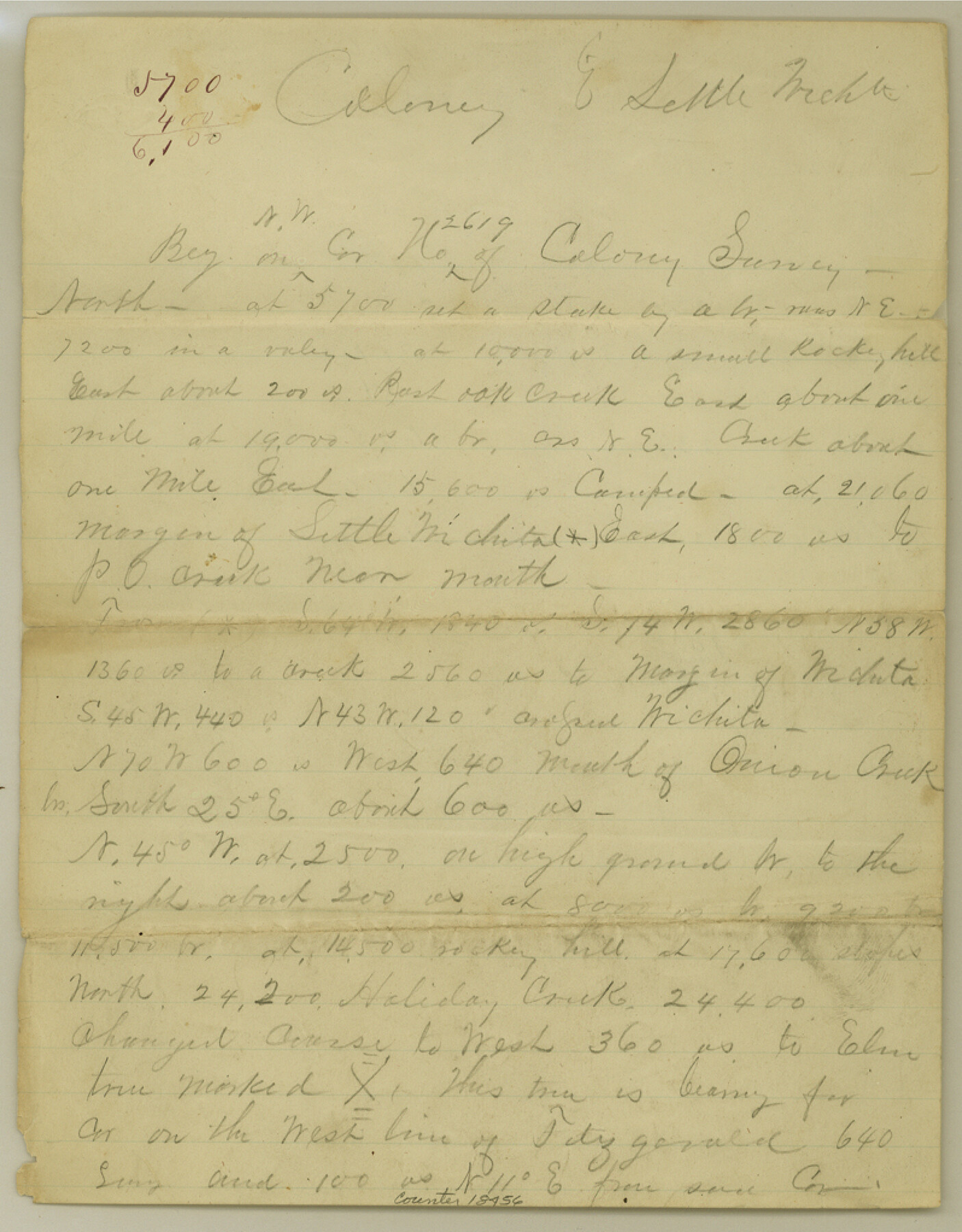
Clay County Sketch File 31
[Connections related to colony surveys in southwest part of the county]
-
Map/Doc
18456
-
Collection
General Map Collection
-
Counties
Archer Clay
-
Subjects
Surveying Sketch File
-
Height x Width
10.2 x 8.0 inches
25.9 x 20.3 cm
-
Medium
paper, manuscript
-
Features
Post Oak Creek
Little Wichita River
Onion Creek
Holiday Creek
Part of: General Map Collection
El Paso County Boundary File 24

Print $32.00
- Digital $50.00
El Paso County Boundary File 24
Size 14.8 x 9.6 inches
Map/Doc 53221
Travis County Working Sketch 36

Print $20.00
- Digital $50.00
Travis County Working Sketch 36
1967
Size 23.4 x 30.8 inches
Map/Doc 69420
Flight Mission No. BRA-7M, Frame 183, Jefferson County

Print $20.00
- Digital $50.00
Flight Mission No. BRA-7M, Frame 183, Jefferson County
1953
Size 18.6 x 22.3 inches
Map/Doc 85551
Milam County Working Sketch 5

Print $20.00
- Digital $50.00
Milam County Working Sketch 5
1963
Size 29.1 x 23.7 inches
Map/Doc 71020
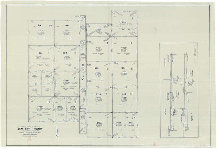
Deaf Smith County Working Sketch 5
Print $40.00
- Digital $50.00
Deaf Smith County Working Sketch 5
1983
Size 37.0 x 53.9 inches
Map/Doc 68645
Red River County Sketch File 14

Print $8.00
- Digital $50.00
Red River County Sketch File 14
Size 13.7 x 9.0 inches
Map/Doc 35133
Gregg County Working Sketch 18

Print $20.00
- Digital $50.00
Gregg County Working Sketch 18
1955
Size 23.3 x 24.0 inches
Map/Doc 63285
Refugio County Sketch File 1

Print $8.00
- Digital $50.00
Refugio County Sketch File 1
1846
Size 12.6 x 7.8 inches
Map/Doc 35235
Montague County Sketch File 9

Print $18.00
- Digital $50.00
Montague County Sketch File 9
1872
Size 12.6 x 11.7 inches
Map/Doc 31724
Map of Mexico and Central America engraved to illustrate Mitchell's new intermediate geography

Print $20.00
- Digital $50.00
Map of Mexico and Central America engraved to illustrate Mitchell's new intermediate geography
1885
Size 9.0 x 12.2 inches
Map/Doc 93523
Flight Mission No. DAH-9M, Frame 200, Orange County

Print $20.00
- Digital $50.00
Flight Mission No. DAH-9M, Frame 200, Orange County
1953
Size 18.6 x 22.4 inches
Map/Doc 86868
Castro County Sketch File 1

Print $6.00
- Digital $50.00
Castro County Sketch File 1
1890
Size 8.8 x 7.8 inches
Map/Doc 17451
You may also like
Val Verde County Sketch File A3

Print $20.00
- Digital $50.00
Val Verde County Sketch File A3
1917
Size 25.6 x 42.3 inches
Map/Doc 10418
Located Line of the Panhandle & Gulf Ry. through State Lands

Print $40.00
- Digital $50.00
Located Line of the Panhandle & Gulf Ry. through State Lands
1904
Size 12.4 x 78.0 inches
Map/Doc 64104
San Augustine County Working Sketch 17

Print $20.00
- Digital $50.00
San Augustine County Working Sketch 17
1963
Size 20.3 x 21.5 inches
Map/Doc 63705
Gaines County Sketch File 5

Print $22.00
- Digital $50.00
Gaines County Sketch File 5
1915
Size 10.8 x 7.2 inches
Map/Doc 23177
Wheeler County Working Sketch 15

Print $20.00
- Digital $50.00
Wheeler County Working Sketch 15
1981
Size 27.9 x 29.3 inches
Map/Doc 72504
General Highway Map, Nacogdoches County, Texas

Print $20.00
General Highway Map, Nacogdoches County, Texas
1961
Size 19.3 x 25.0 inches
Map/Doc 79607
Aransas County NRC Article 33.136 Sketch 12

Print $44.00
- Digital $50.00
Aransas County NRC Article 33.136 Sketch 12
2012
Size 36.0 x 48.0 inches
Map/Doc 94510

Flight Mission No. BRA-8M, Frame 149, Jefferson County

Print $20.00
- Digital $50.00
Flight Mission No. BRA-8M, Frame 149, Jefferson County
1953
Size 18.8 x 22.4 inches
Map/Doc 85641
Map of part of Matagorda Island

Print $20.00
- Digital $50.00
Map of part of Matagorda Island
1859
Size 30.2 x 32.0 inches
Map/Doc 69982
The Republic County of Washington. May 24, 1838

Print $20.00
The Republic County of Washington. May 24, 1838
2020
Size 20.3 x 21.7 inches
Map/Doc 96303
Hamilton County Working Sketch 20

Print $20.00
- Digital $50.00
Hamilton County Working Sketch 20
1953
Size 32.5 x 30.8 inches
Map/Doc 63358