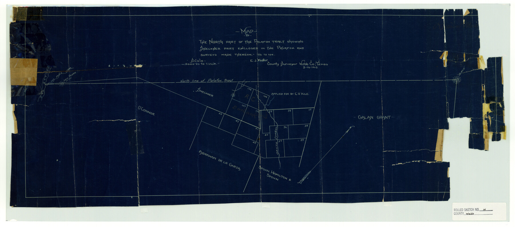
Webb County Rolled Sketch 14
Map of the north part of the Palafox tract showing Sneckner part enclosed in the Palafox and surveys made thereon - 106 to 109
-
Map/Doc
8178
-
Collection
General Map Collection
-
Object Dates
1915/3/22 (File Date)
1915/3/16 (Creation Date)
-
People and Organizations
E.J. Foster (Surveyor/Engineer)
-
Counties
Webb
-
Subjects
Surveying Rolled Sketch
-
Height x Width
12.6 x 28.5 inches
32.0 x 72.4 cm
-
Medium
blueprint/diazo
-
Scale
1" = 2000 varas
Part of: General Map Collection
Coke County Sketch File 31

Print $4.00
- Digital $50.00
Coke County Sketch File 31
Size 14.1 x 8.8 inches
Map/Doc 18643
Current Miscellaneous File 97

Print $16.00
- Digital $50.00
Current Miscellaneous File 97
1847
Size 11.3 x 8.8 inches
Map/Doc 74329
Menard County Working Sketch 20

Print $20.00
- Digital $50.00
Menard County Working Sketch 20
1947
Size 38.5 x 34.9 inches
Map/Doc 70967
Menard County

Print $20.00
- Digital $50.00
Menard County
1942
Size 40.1 x 43.7 inches
Map/Doc 66928
San Felipe Town Tract & Adjoining Survey for S. F. Austin and A. Lester

Print $2.00
- Digital $50.00
San Felipe Town Tract & Adjoining Survey for S. F. Austin and A. Lester
Size 9.9 x 8.1 inches
Map/Doc 78368
[Portion of Panola Judicial District]
![78365, [Portion of Panola Judicial District], General Map Collection](https://historictexasmaps.com/wmedia_w700/maps/78365.tif.jpg)
Print $3.00
- Digital $50.00
[Portion of Panola Judicial District]
1841
Size 17.1 x 10.0 inches
Map/Doc 78365
Sutton County Rolled Sketch 61

Print $20.00
- Digital $50.00
Sutton County Rolled Sketch 61
1890
Size 27.8 x 23.4 inches
Map/Doc 7898
San Patricio County Rolled Sketch 40

Print $20.00
- Digital $50.00
San Patricio County Rolled Sketch 40
1917
Size 26.0 x 36.0 inches
Map/Doc 7726
Houston County Sketch File 33

Print $20.00
- Digital $50.00
Houston County Sketch File 33
1894
Size 16.9 x 18.4 inches
Map/Doc 11790
Chambers County Sketch File 51

Print $35.00
- Digital $50.00
Chambers County Sketch File 51
1935
Size 14.3 x 9.0 inches
Map/Doc 18068
Webb County Rolled Sketch 11

Print $20.00
- Digital $50.00
Webb County Rolled Sketch 11
1911
Size 37.1 x 34.7 inches
Map/Doc 10118
General Chart of the Coast No. XVI - Gulf Coast from Galveston to the Rio Grande

Print $20.00
- Digital $50.00
General Chart of the Coast No. XVI - Gulf Coast from Galveston to the Rio Grande
1883
Size 26.8 x 18.2 inches
Map/Doc 72736
You may also like

Hardeman County Working Sketch 9

Print $20.00
- Digital $50.00
Hardeman County Working Sketch 9
1953
Size 44.4 x 27.2 inches
Map/Doc 63390
Hansford County Working Sketch 2

Print $40.00
- Digital $50.00
Hansford County Working Sketch 2
1934
Size 42.7 x 54.4 inches
Map/Doc 63374
Webb County Working Sketch 28

Print $20.00
- Digital $50.00
Webb County Working Sketch 28
1933
Size 32.8 x 22.4 inches
Map/Doc 72393
Brewster County Rolled Sketch 123

Print $25.00
- Digital $50.00
Brewster County Rolled Sketch 123
Size 10.1 x 15.3 inches
Map/Doc 43129
Comanche County Sketch File 16

Print $6.00
- Digital $50.00
Comanche County Sketch File 16
Size 11.8 x 11.5 inches
Map/Doc 19082
Newton County Working Sketch 3

Print $20.00
- Digital $50.00
Newton County Working Sketch 3
1924
Size 18.2 x 20.6 inches
Map/Doc 71249
The United States of America

Print $20.00
- Digital $50.00
The United States of America
1866
Size 22.4 x 18.2 inches
Map/Doc 72645
La Salle County Sketch File 24

Print $4.00
- Digital $50.00
La Salle County Sketch File 24
1877
Size 9.2 x 6.1 inches
Map/Doc 29547
Presidio County Sketch File 3

Print $6.00
- Digital $50.00
Presidio County Sketch File 3
1941
Size 8.5 x 7.7 inches
Map/Doc 34423
Jeff Davis County Working Sketch 21

Print $20.00
- Digital $50.00
Jeff Davis County Working Sketch 21
1957
Size 25.2 x 44.0 inches
Map/Doc 66516
Andrews County

Print $40.00
- Digital $50.00
Andrews County
1925
Size 56.5 x 42.8 inches
Map/Doc 89866